TopoQuest Logo
Do you find TopoQuest useful?
Help keep TopoQuest running and adding new maps/features by donating!
Bitcoin:  19c7KJd3qBynnjoSw5npx9KScwjBe4ifkT
Litecoin:  LXs6TkuXGGXo1vDsWCkWVdjQX94eUKd6ui
Home View Maps Find Maps Find Places Resources & Links


Weimar, Texas Topographic Map

USGS Map Title: Weimar, TX
USGS Map MRC: 29096F7
DRG (GeoTIFF) Download: o29096f7.tif


Neighboring USGS Topographic Map Quads:


  Swiss Alp, TX  
29096G8
 

  Ammannsville, TX  
29096G7
 

  Ellinger, TX  
29096G6
 

  Schulenburg, TX  
29096F8
 

  Weimar, TX  
29096F7
 

  Borden, TX  
29096F6
 

  Moravia, TX  
29096E8
 

  Oakland, TX  
29096E7
 

  Sawmill Branch, TX  
29096E6


Map MRC Location:

N30°
W97°
N30°
W96°
H8 H7 H6 H5 H4 H3 H2 H1
G8 G7 G6 G5 G4 G3 G2 G1
F8 F7 F6 F5 F4 F3 F2 F1
E8 E7 E6 E5 E4 E3 E2 E1
D8 D7 D6 D5 D4 D3 D2 D1
C8 C7 C6 C5 C4 C3 C2 C1
B8 B7 B6 B5 B4 B3 B2 B1
A8 A7 A6 A5 A4 A3 A2 A1
N29°
W97°
N29°
W96°

Weimar, TX USGS 1:24K Topographic Map Preview:
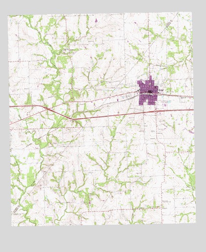
Weimar, TX USGS Topographic Map
Click on map above to begin viewing in our Map Viewer.

This topographic map contains these locations and features:
Feature Name Type Latitude Longitude GNIS ID View Map
Black BayouStreamN29.6477°W96.8644°1330731View Map
Boeer CemeteryCemeteryN29.6858°W96.7705°1330980View Map
City of WeimarCivilN29.7001°W96.7773°2412202View Map
Clear Creek CemeteryCemeteryN29.6397°W96.8247°1332936View Map
Colorado - Fayette Medical CenterHospitalN29.6944°W96.7882°2015602View Map
Colorado County Constable's Office Precinct 2BuildingN29.7023°W96.7802°2739509View Map
DubinaPopulated PlaceN29.7288°W96.8330°1378231View Map
Elm BranchStreamN29.6450°W96.8664°1335341View Map
Frisco Public LibraryBuildingN29.6563°W96.8072°2014955View Map
Hehr CemeteryCemeteryN29.6811°W96.7714°1337560View Map
Hill Memorial ParkParkN29.7033°W96.7644°2029225View Map
Hill Memorial ParkCemeteryN29.7044°W96.7675°1337784View Map
Maribelle M Davis LibraryBuildingN29.6666°W96.7503°2014859View Map
Middle CreekStreamN29.6713°W96.8544°1341480View Map
New BielauPopulated PlaceN29.6344°W96.7733°2034846View Map
New Bielau Community CenterBuildingN29.6383°W96.7725°1342437View Map
Pleasant Hill ChurchChurchN29.7000°W96.7589°1344212View Map
Renner Frankford Branch LibraryBuildingN29.6800°W96.7947°2014798View Map
Saint Cyril ChurchChurchN29.7297°W96.8339°1345884View Map
Saint Michaels SchoolSchoolN29.7077°W96.7794°1346052View Map
Schulenburg DivisionCivilN29.7402°W96.8665°1939177View Map
Simon Pytlovany HouseBuildingN29.7130°W96.8391°2032612View Map
The Heritage Society Museum of WeimarBuildingN29.7022°W96.7728°2014285View Map
Trinity ChurchChurchN29.6341°W96.7725°1348777View Map
Veterans Memorial Baseball ParkParkN29.7080°W96.7853°2028032View Map
WeimarPopulated PlaceN29.7030°W96.7805°1349609View Map
Weimar Elementary SchoolSchoolN29.7036°W96.7872°2004808View Map
Weimar High SchoolSchoolN29.7036°W96.7872°2004809View Map
Weimar Junior High SchoolSchoolN29.7050°W96.7761°2004810View Map
Weimar Police DepartmentBuildingN29.6912°W96.7575°2739214View Map
Weimar Post OfficePost OfficeN29.7023°W96.7802°2731673View Map
Weimar Public LibraryBuildingN29.7022°W96.7814°2014750View Map
Weimar Volunteer Fire DepartmentBuildingN29.7024°W96.7785°2552351View Map
Weimer City HallBuildingN29.7023°W96.7797°2753994View Map

Note: Coordinates in the location and feature list above are referenced to NAD83 datum.


Copyright (C) 2008-2025 Ryan Niemi / Sunset Dynamics ... All Rights Reserved