TopoQuest Logo
Do you find TopoQuest useful?
Help keep TopoQuest running and adding new maps/features by donating!
Bitcoin:  19c7KJd3qBynnjoSw5npx9KScwjBe4ifkT
Litecoin:  LXs6TkuXGGXo1vDsWCkWVdjQX94eUKd6ui
Home View Maps Find Maps Find Places Resources & Links


Wells, Vermont Topographic Map

USGS Map Title: Wells, VT
USGS Map MRC: 43073D2
DRG (GeoTIFF) Download: o43073d2.tif


Neighboring USGS Topographic Map Quads:


  Thorn Hill, NY  
43073E3
 

  Poultney, VT  
43073E2
 

  West Rutland, VT  
43073E1
 

  Granville, NY  
43073D3
 

  Wells, VT  
43073D2
 

  Middletown Springs, VT  
43073D1
 

  West Pawlet, VT  
43073C3
 

  Pawlet, VT  
43073C2
 

  Dorset, VT  
43073C1


Map MRC Location:

N44°
W74°
N44°
W73°
H8 H7 H6 H5 H4 H3 H2 H1
G8 G7 G6 G5 G4 G3 G2 G1
F8 F7 F6 F5 F4 F3 F2 F1
E8 E7 E6 E5 E4 E3 E2 E1
D8 D7 D6 D5 D4 D3 D2 D1
C8 C7 C6 C5 C4 C3 C2 C1
B8 B7 B6 B5 B4 B3 B2 B1
A8 A7 A6 A5 A4 A3 A2 A1
N43°
W74°
N43°
W73°

Wells, VT USGS 1:24K Topographic Map Preview:
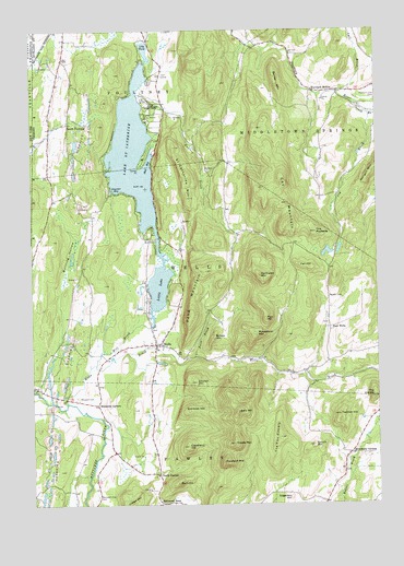
Wells, VT USGS Topographic Map
Click on map above to begin viewing in our Map Viewer.

This topographic map contains these locations and features:
Feature Name Type Latitude Longitude GNIS ID View Map
Atwater BayBayN43.4592°W73.2184°1456185View Map
Bald HillSummitN43.3995°W73.1751°1456217View Map
Barden CemeteryCemeteryN43.4298°W73.1420°1456250View Map
Barker MountainSummitN43.4853°W73.1596°1456255View Map
Blossom CemeteryCemeteryN43.4034°W73.2329°1456486View Map
Blossoms CornersLocaleN43.4012°W73.2257°1456487View Map
Boczek Marsh Wildlife Management AreaParkN43.4981°W73.2204°1921753View Map
Brimstone CornersLocaleN43.3887°W73.1346°1456572View Map
Bullfrog HollowValleyN43.4312°W73.2387°1456642View Map
Burnham HollowPopulated PlaceN43.4842°W73.1473°1456667View Map
Burt HillSummitN43.3809°W73.1971°1456684View Map
ButternutPopulated PlaceN43.3754°W73.2023°1456697View Map
Camp Kinni KinnicLocaleN43.4776°W73.2082°1456733View Map
Cleveland HillSummitN43.3906°W73.1932°1456919View Map
Cones PointCapeN43.4642°W73.2098°1456994View Map
Coy BrookStreamN43.4778°W73.1271°1457038View Map
Coy MountainSummitN43.4490°W73.1557°1457039View Map
East WellsPopulated PlaceN43.4217°W73.1412°1460414View Map
East Wells CemeteryCemeteryN43.4233°W73.1424°1921862View Map
Edgerton HillSummitN43.3767°W73.1565°1457340View Map
Endless BrookStreamN43.4831°W73.2101°1457370View Map
Fan HillSummitN43.4373°W73.1490°1457407View Map
Hall BayBayN43.4662°W73.2059°1457693View Map
Haystack MountainSummitN43.3862°W73.1807°1457777View Map
Indian HillSummitN43.3751°W73.2143°1457963View Map
Lake Saint CatherineLakeN43.4675°W73.2123°1459322View Map
Lake Saint Catherine Golf CourseLocaleN43.4890°W73.2009°1921958View Map
Lake Saint Catherine State ParkParkN43.4803°W73.2048°1458140View Map
Lily PondLakeN43.4954°W73.2079°1458214View Map
Lincoln HillSummitN43.4073°W73.1901°1458221View Map
Little LakeLakeN43.4329°W73.2033°1458243View Map
Little Pond DamDamN43.4267°W73.2079°1766461View Map
Melcher DamDamN43.4467°W73.1946°1766519View Map
Mettawee Community SchoolSchoolN43.3857°W73.2236°2427547View Map
Middle MountainSummitN43.3912°W73.1768°1458432View Map
Mill BrookStreamN43.4117°W73.2265°1458455View Map
Moosehorn MountainSummitN43.4198°W73.1679°1458529View Map
Mountain View CemeteryCemeteryN43.3773°W73.2265°1458590View Map
North PawletPopulated PlaceN43.3829°W73.2040°1458751View Map
Northeast Developers DamDamN43.4267°W73.2129°1766521View Map
Northeast MountainSummitN43.4353°W73.1665°1458776View Map
Orcutt HillSummitN43.3906°W73.1479°1458851View Map
Pine HillSummitN43.4240°W73.1646°1458971View Map
Pond MountainSummitN43.4248°W73.1912°1459038View Map
Saint Catherine MountainSummitN43.4609°W73.1926°1459321View Map
Schiff DamDamN43.4417°W73.1379°1766492View Map
Schmidt DamDamN43.4417°W73.1405°1766491View Map
Simonds HillSummitN43.3998°W73.1926°1459514View Map
Single HillSummitN43.4190°W73.1832°1459521View Map
Snow BrookStreamN43.4140°W73.1901°1459554View Map
South BrookStreamN43.4809°W73.1329°1459576View Map
South PoultneyPopulated PlaceN43.4756°W73.2359°1459608View Map
Stiles CemeteryCemeteryN43.4653°W73.1776°1922138View Map
Tadmer HillSummitN43.3987°W73.1384°1459812View Map
The CobbleSummitN43.4034°W73.1262°1459848View Map
The Fox CobbleSummitN43.3928°W73.1598°1459855View Map
The PinnaclePillarN43.4467°W73.1462°1459887View Map
Town CemeteryCemeteryN43.4181°W73.2095°1922162View Map
Town of Middletown SpringsCivilN43.4820°W73.1273°1462148View Map
Town of WellsCivilN43.4324°W73.1896°1462248View Map
Vail BrookStreamN43.4837°W73.1382°1460006View Map
WellsPopulated PlaceN43.4173°W73.2043°1460102View Map
Wells BrookStreamN43.4020°W73.2371°1460104View Map
Wells Census Designated PlaceCensusN43.4208°W73.2075°2586659View Map
Wells Post OfficePost OfficeN43.4176°W73.2045°1922190View Map
Wells Village SchoolSchoolN43.4182°W73.2073°1922191View Map
Wells Volunteer Fire DepartmentBuildingN43.4168°W73.2109°2121273View Map

Note: Coordinates in the location and feature list above are referenced to NAD83 datum.


Copyright (C) 2008-2024 Ryan Niemi / Sunset Dynamics ... All Rights Reserved