TopoQuest Logo
Do you find TopoQuest useful?
Help keep TopoQuest running and adding new maps/features by donating!
Bitcoin:  19c7KJd3qBynnjoSw5npx9KScwjBe4ifkT
Litecoin:  LXs6TkuXGGXo1vDsWCkWVdjQX94eUKd6ui
Home View Maps Find Maps Find Places Resources & Links


West Pawlet, Vermont Topographic Map

USGS Map Title: West Pawlet, VT
USGS Map MRC: 43073C3
DRG (GeoTIFF) Download: o43073c3.tif


Neighboring USGS Topographic Map Quads:


  Fort Ann, NY  
43073D4
 

  Granville, NY  
43073D3
 

  Wells, VT  
43073D2
 

  Hartford, NY  
43073C4
 

  West Pawlet, VT  
43073C3
 

  Pawlet, VT  
43073C2
 

  Cossayuna, NY  
43073B4
 

  Salem, NY  
43073B3
 

  West Rupert, VT  
43073B2


Map MRC Location:

N44°
W74°
N44°
W73°
H8 H7 H6 H5 H4 H3 H2 H1
G8 G7 G6 G5 G4 G3 G2 G1
F8 F7 F6 F5 F4 F3 F2 F1
E8 E7 E6 E5 E4 E3 E2 E1
D8 D7 D6 D5 D4 D3 D2 D1
C8 C7 C6 C5 C4 C3 C2 C1
B8 B7 B6 B5 B4 B3 B2 B1
A8 A7 A6 A5 A4 A3 A2 A1
N43°
W74°
N43°
W73°

West Pawlet, VT USGS 1:24K Topographic Map Preview:
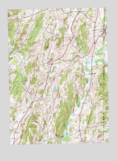
West Pawlet, VT USGS Topographic Map
Click on map above to begin viewing in our Map Viewer.

This topographic map contains these locations and features:
Feature Name Type Latitude Longitude GNIS ID View Map
Birch Hill FarmLocaleN43.3233°W73.2742°2559433View Map
Braymer CemeteryCemeteryN43.3185°W73.2701°944662View Map
Braymer School (historical)SchoolN43.3142°W73.2707°944663View Map
Burch CemeteryCemeteryN43.3338°W73.3334°945194View Map
Castle GreenWoodsN43.3004°W73.3646°945990View Map
Chamberlin MillsLocaleN43.2556°W73.3121°979668View Map
Dead CreekStreamN43.2834°W73.3534°948120View Map
Dick HillSummitN43.3567°W73.3737°948431View Map
East HebronPopulated PlaceN43.2617°W73.2865°949099View Map
East Hebron CemeteryCemeteryN43.2549°W73.2883°949100View Map
Glasier CemeteryCemeteryN43.3150°W73.2910°951157View Map
Green PondLakeN43.3393°W73.2832°951717View Map
Grimes HillSummitN43.3095°W73.2901°951827View Map
Hebron ChurchChurchN43.2609°W73.3676°952511View Map
Lily PondLakeN43.3358°W73.3665°955322View Map
Moorehouse CemeteryCemeteryN43.3168°W73.3220°957605View Map
Mount TomSummitN43.3395°W73.3268°967613View Map
North HebronPopulated PlaceN43.3231°W73.3204°958811View Map
Pine HillSummitN43.2795°W73.3059°960470View Map
PorterPopulated PlaceN43.2937°W73.2776°972963View Map
Pumpkin HillSummitN43.3692°W73.3740°961966View Map
Reynolds CemeteryCemeteryN43.3470°W73.3526°962427View Map
Round MountainSummitN43.3037°W73.2571°962981View Map
School Number 11 (historical)SchoolN43.2526°W73.3307°974999View Map
School Number 4 (historical)SchoolN43.3523°W73.3196°975382View Map
School Number 5 (historical)SchoolN43.2842°W73.3487°975445View Map
School Number 5 (historical)SchoolN43.3540°W73.2651°975447View Map
School Number 8 (historical)SchoolN43.2873°W73.2809°975608View Map
SlatevillePopulated PlaceN43.3306°W73.2893°973075View Map
Smith CemeteryCemeteryN43.2989°W73.2883°965467View Map
Smith PondLakeN43.3013°W73.3163°965508View Map
South GranvillePopulated PlaceN43.3715°W73.2851°965755View Map
South Granville Congregational ChurchChurchN43.3719°W73.2869°2500693View Map
South Granville Congregational Church CemeteryCemeteryN43.3735°W73.2861°2500697View Map
Tanner CemeteryCemeteryN43.3576°W73.3262°967039View Map
Taylor Hill CemeteryCemeteryN43.3474°W73.3285°967089View Map
TipladyPopulated PlaceN43.2520°W73.2837°973159View Map
Town of HebronCivilN43.2816°W73.3239°979059View Map
West PawletPopulated PlaceN43.3537°W73.2521°1460165View Map
West Pawlet Post OfficePost OfficeN43.3531°W73.2518°1922194View Map
West Pawlet SchoolSchoolN43.3556°W73.2518°1922195View Map
West Pawlet United ChurchChurchN43.3545°W73.2512°1922196View Map
West Pawlet Volunteer Fire DepartmentBuildingN43.3533°W73.2509°2121272View Map

Note: Coordinates in the location and feature list above are referenced to NAD83 datum.


Copyright (C) 2008-2024 Ryan Niemi / Sunset Dynamics ... All Rights Reserved