TopoQuest Logo
Do you find TopoQuest useful?
Help keep TopoQuest running and adding new maps/features by donating!
Bitcoin:  19c7KJd3qBynnjoSw5npx9KScwjBe4ifkT
Litecoin:  LXs6TkuXGGXo1vDsWCkWVdjQX94eUKd6ui
Home View Maps Find Maps Find Places Resources & Links


West Branch, Michigan Topographic Map

USGS Map Title: West Branch, MI
USGS Map MRC: 44084C2
DRG (GeoTIFF) Download: o44084c2.tif


Neighboring USGS Topographic Map Quads:


  Saint Helen NE, MI  
44084D3
 

  Damon, MI  
44084D2
 

  Rose City, MI  
44084D1
 

  Ogemaw Springs, MI  
44084C3
 

  West Branch, MI  
44084C2
 

  Selkirk, MI  
44084C1
 

  Edwards, MI  
44084B3
 

  Sterling NW, MI  
44084B2
 

  Skidway Lake, MI  
44084B1


Map MRC Location:

N45°
W85°
N45°
W84°
H8 H7 H6 H5 H4 H3 H2 H1
G8 G7 G6 G5 G4 G3 G2 G1
F8 F7 F6 F5 F4 F3 F2 F1
E8 E7 E6 E5 E4 E3 E2 E1
D8 D7 D6 D5 D4 D3 D2 D1
C8 C7 C6 C5 C4 C3 C2 C1
B8 B7 B6 B5 B4 B3 B2 B1
A8 A7 A6 A5 A4 A3 A2 A1
N44°
W85°
N44°
W84°

West Branch, MI USGS 1:24K Topographic Map Preview:
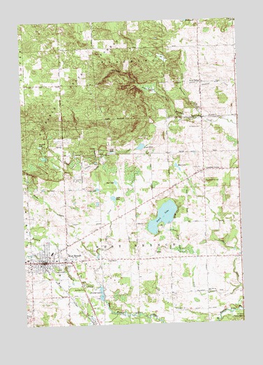
West Branch, MI USGS Topographic Map
Click on map above to begin viewing in our Map Viewer.

This topographic map contains these locations and features:
Feature Name Type Latitude Longitude GNIS ID View Map
Apple Valley Golf CourseLocaleN44.3069°W84.2089°2503048View Map
Baker CollegeSchoolN44.2769°W84.2317°2501998View Map
Beulah MissionChurchN44.2767°W84.1972°2501973View Map
Beulah MissionChurchN44.2770°W84.1975°621257View Map
Bortz Health Care - West BranchHospitalN44.2714°W84.2303°2501982View Map
Brewery CreekStreamN44.2725°W84.2267°621941View Map
Brookside CemeteryCemeteryN44.2750°W84.2261°622045View Map
Campbells CornersPopulated PlaceN44.3131°W84.1456°622670View Map
Campbells Corners CemeteryCemeteryN44.3086°W84.1464°622671View Map
Campbells Corners Post Office (historical)Post OfficeN44.3131°W84.1456°2503045View Map
Cedar Lane FarmsLocaleN44.2925°W84.1969°2725293View Map
Church of ChristChurchN44.2764°W84.2447°2501988View Map
Church of GodChurchN44.2708°W84.2422°2501964View Map
Church of Jesus Christ of Latter Day SaintsChurchN44.3417°W84.2264°2501991View Map
Church of the NazareneChurchN44.2753°W84.2386°2501986View Map
City of West BranchCivilN44.2737°W84.2360°1627248View Map
Community of Christ ChurchChurchN44.2764°W84.2283°2501985View Map
Country Village Estates Mobile Home ParkPopulated PlaceN44.2653°W84.2167°2501996View Map
Court Street ClinicHospitalN44.2681°W84.2458°2501979View Map
Crane CreekStreamN44.3156°W84.2056°624009View Map
Crapo CreekStreamN44.3031°W84.1992°624016View Map
Crapo LakeLakeN44.3059°W84.2070°624020View Map
Deer LakeLakeN44.3086°W84.1967°624476View Map
East Side SchoolSchoolN44.2634°W84.1450°625262View Map
Engle PondLakeN44.3230°W84.1815°625598View Map
Evergreen ClinicHospitalN44.2694°W84.2458°2501969View Map
First United Methodist ChurchChurchN44.2833°W84.2250°2501984View Map
Flowage LakeLakeN44.2644°W84.2083°626192View Map
Foose SwampSwampN44.3470°W84.1761°626214View Map
Geory SpringSpringN44.3495°W84.1467°626745View Map
Grow CreekStreamN44.2528°W84.1389°627480View Map
Haskell LakeLakeN44.3242°W84.2394°627917View Map
Irons ParkParkN44.2739°W84.2314°629084View Map
Kingdom Hall of Jehovah's WitnessesChurchN44.3175°W84.1458°2501992View Map
Lang PondLakeN44.3211°W84.1984°630134View Map
Little Klacking CreekStreamN44.3347°W84.1472°630655View Map
Main Street Family Practice ClinicHospitalN44.2761°W84.2325°2501980View Map
Michigan Department of Natural Resources West Branch Field OfficeBuildingN44.3463°W84.2257°2627024View Map
Michigan State Police District 3 West Branch Post 32BuildingN44.2760°W84.2271°2780861View Map
Miller SchoolSchoolN44.2917°W84.1850°632399View Map
Mud LakeLakeN44.3145°W84.1609°632991View Map
Ogemaw CountyCivilN44.3349°W84.1264°1623007View Map
Ogemaw County CourthouseBuildingN44.2753°W84.2458°2501961View Map
Ogemaw County Emergency Medical Services Authority Rose CityBuildingN44.3548°W84.1273°2662005View Map
Ogemaw County Historical MuseumBuildingN44.2753°W84.2408°2501959View Map
Ogemaw County Sheriff's OfficeBuildingN44.2752°W84.2458°2501968View Map
Ogemaw CreekStreamN44.2667°W84.2125°1625559View Map
Ogemaw Fire DepartmentBuildingN44.2774°W84.2390°2501965View Map
Ogemaw Heights High SchoolSchoolN44.3111°W84.1264°2502000View Map
Ogemaw State ForestForestN44.3511°W84.2194°1621093View Map
Peach LakeLakeN44.2942°W84.1699°634513View Map
Peach Lake CreekStreamN44.2647°W84.1264°634514View Map
Primary Care Practice ClinicHospitalN44.2764°W84.2306°2501967View Map
Rapid CreekStreamN44.3186°W84.2056°635649View Map
Rifle CreekStreamN44.2664°W84.2069°635918View Map
Rifle LakeLakeN44.3018°W84.1982°635919View Map
Saint John Lutheran ChurchChurchN44.3492°W84.2297°2501978View Map
Saint Joseph West Branch SchoolSchoolN44.2769°W84.2497°2501975View Map
Saint Joseph's CemeteryCemeteryN44.2717°W84.2314°2503054View Map
Saint Joseph's ChurchChurchN44.2764°W84.2469°2501987View Map
Saint Josephs CemeteryCemeteryN44.3308°W84.1467°636803View Map
Saint Josephs ChurchChurchN44.3353°W84.1419°636808View Map
Seventh Day Adventist ChurchChurchN44.2772°W84.2083°2501990View Map
Surline Elementary SchoolSchoolN44.2797°W84.2336°2501999View Map
Township of West BranchCivilN44.2920°W84.1842°1627249View Map
Trinity Episcopal ChurchChurchN44.2761°W84.2353°2501977View Map
Twin Pines Mobile Home ParkPopulated PlaceN44.2622°W84.2169°2501995View Map
West BranchPopulated PlaceN44.2764°W84.2386°1616022View Map
West Branch Assembly ChurchChurchN44.2656°W84.2428°2501976View Map
West Branch City HallBuildingN44.2775°W84.2397°2501963View Map
West Branch Country ClubLocaleN44.2806°W84.2231°2503047View Map
West Branch Medical ClinicHospitalN44.2714°W84.2422°2501966View Map
West Branch Oil FieldOilfieldN44.2636°W84.1853°1623697View Map
West Branch Police DepartmentBuildingN44.2768°W84.2360°2737375View Map
West Branch Post OfficePost OfficeN44.2753°W84.2383°2501983View Map
West Branch Public LibraryBuildingN44.2772°W84.2397°2501962View Map
West Branch Regional Medical CenterHospitalN44.2638°W84.2446°2501981View Map
West Branch StationLocaleN44.2764°W84.2414°2501960View Map
West Branch Travel Trailer ParkPopulated PlaceN44.2567°W84.2217°2501994View Map
Woods CreekStreamN44.2781°W84.2081°1616790View Map

Note: Coordinates in the location and feature list above are referenced to NAD83 datum.


Copyright (C) 2008-2024 Ryan Niemi / Sunset Dynamics ... All Rights Reserved