TopoQuest Logo
Do you find TopoQuest useful?
Help keep TopoQuest running and adding new maps/features by donating!
Bitcoin:  19c7KJd3qBynnjoSw5npx9KScwjBe4ifkT
Litecoin:  LXs6TkuXGGXo1vDsWCkWVdjQX94eUKd6ui
Home View Maps Find Maps Find Places Resources & Links


West Middletown, Pennsylvania Topographic Map

USGS Map Title: West Middletown, PA
USGS Map MRC: 40080B4
DRG (GeoTIFF) Download: o40080b4.tif


Neighboring USGS Topographic Map Quads:


  Steubenville East, OH  
40080C5
 

  Avella, PA  
40080C4
 

  Midway, PA  
40080C3
 

  Bethany, WV  
40080B5
 

  West Middletown, PA  
40080B4
 

  Washington West, PA  
40080B3
 

  Valley Grove, WV  
40080A5
 

  Claysville, PA  
40080A4
 

  Prosperity, PA  
40080A3


Map MRC Location:

N41°
W81°
N41°
W80°
H8 H7 H6 H5 H4 H3 H2 H1
G8 G7 G6 G5 G4 G3 G2 G1
F8 F7 F6 F5 F4 F3 F2 F1
E8 E7 E6 E5 E4 E3 E2 E1
D8 D7 D6 D5 D4 D3 D2 D1
C8 C7 C6 C5 C4 C3 C2 C1
B8 B7 B6 B5 B4 B3 B2 B1
A8 A7 A6 A5 A4 A3 A2 A1
N40°
W81°
N40°
W80°

West Middletown, PA USGS 1:24K Topographic Map Preview:
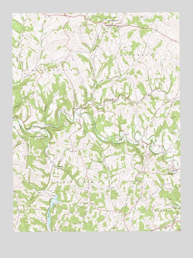
West Middletown, PA USGS Topographic Map
Click on map above to begin viewing in our Map Viewer.

This topographic map contains these locations and features:
Feature Name Type Latitude Longitude GNIS ID View Map
AchesonPopulated PlaceN40.1951°W80.4512°1168039View Map
Borough of West MiddletownCivilN40.2432°W80.4253°1215683View Map
Brush RunStreamN40.1931°W80.4523°1170457View Map
Buck RunStreamN40.1915°W80.4492°1170540View Map
BudavillePopulated PlaceN40.1620°W80.4662°1170591View Map
Camp BuffaloLocaleN40.1787°W80.4217°1170983View Map
Cross Creek County ParkParkN40.2487°W80.3998°1206040View Map
DonleyPopulated PlaceN40.1504°W80.4278°1173377View Map
DunklePopulated PlaceN40.2131°W80.4187°1203456View Map
Dunkle RunStreamN40.1990°W80.4409°1198058View Map
Dutch ForkStreamN40.1840°W80.4865°1173648View Map
Dutch Fork ChurchChurchN40.1615°W80.4665°1173649View Map
Dutch Fork DamDamN40.1451°W80.4681°1194578View Map
Dutch Fork LakeReservoirN40.1410°W80.4693°1173650View Map
Grove ChurchChurchN40.2423°W80.4184°1176272View Map
Hanen RunStreamN40.2087°W80.4378°1217351View Map
Hupp CemeteryCemeteryN40.1378°W80.4834°1177639View Map
Indian Camp RunStreamN40.2145°W80.4915°1177736View Map
Jolley HollowValleyN40.2087°W80.4369°1178138View Map
Kearns FarmsLocaleN40.2092°W80.4256°2708345View Map
Krajacic FarmsLocaleN40.2381°W80.3842°2708346View Map
Manchester Schoolhouse (historical)SchoolN40.2492°W80.4715°1206039View Map
McMillanPopulated PlaceN40.1329°W80.4465°1201590View Map
Mount Hope CemeteryCemeteryN40.2220°W80.4623°1181707View Map
Narigan RunStreamN40.1859°W80.4753°1182165View Map
Neely Schoolhouse (historical)SchoolN40.1917°W80.3840°1206038View Map
Noble BridgeBridgeN40.1778°W80.4181°1182490View Map
Opossum HollowValleyN40.2277°W80.4413°1183009View Map
Polecat HollowValleyN40.1745°W80.4096°1184193View Map
Ralston RunStreamN40.1495°W80.4753°1184617View Map
Rogers CemeteryCemeteryN40.1259°W80.4695°1185388View Map
Rush Run FarmLocaleN40.2158°W80.4214°2708348View Map
State Game Lands Number 232ParkN40.1787°W80.4798°1188497View Map
Stroughton LakeReservoirN40.1581°W80.4419°1194597View Map
Stroughton Lake DamDamN40.1584°W80.4415°1194596View Map
TaylorstownPopulated PlaceN40.1598°W80.3781°1189322View Map
Taylorstown Census Designated PlaceCensusN40.1565°W80.3869°2584517View Map
Taylorstown Post OfficePost OfficeN40.1598°W80.3778°2779927View Map
Taylorstown Volunteer Fire Department Station 36BuildingN40.1594°W80.3784°2645403View Map
Timber LakeReservoirN40.1384°W80.3778°1189571View Map
Timber Lake DamDamN40.1384°W80.3781°1194573View Map
Township of BlaineCivilN40.1792°W80.3952°1217182View Map
Township of DonegalCivilN40.1346°W80.4660°1217189View Map
Township of HopewellCivilN40.2287°W80.3908°1217194View Map
Township of IndependenceCivilN40.2354°W80.4819°1217195View Map
West MiddletownPopulated PlaceN40.2428°W80.4273°1191069View Map
West Middletown Post OfficePost OfficeN40.2421°W80.4206°2779759View Map
West Middletown Volunteer Fire DepartmentBuildingN40.2427°W80.4260°2645059View Map
Wolf RunStreamN40.1606°W80.3765°1198143View Map
Zion ChurchChurchN40.1712°W80.4551°1191977View Map

Note: Coordinates in the location and feature list above are referenced to NAD83 datum.


Copyright (C) 2008-2024 Ryan Niemi / Sunset Dynamics ... All Rights Reserved