TopoQuest Logo
Do you find TopoQuest useful?
Help keep TopoQuest running and adding new maps/features by donating!
Bitcoin:  19c7KJd3qBynnjoSw5npx9KScwjBe4ifkT
Litecoin:  LXs6TkuXGGXo1vDsWCkWVdjQX94eUKd6ui
Home View Maps Find Maps Find Places Resources & Links


Midway, Pennsylvania Topographic Map

USGS Map Title: Midway, PA
USGS Map MRC: 40080C3
DRG (GeoTIFF) Download: o40080c3.tif


Neighboring USGS Topographic Map Quads:


  Burgettstown, PA  
40080D4
 

  Clinton, PA  
40080D3
 

  Oakdale, PA  
40080D2
 

  Avella, PA  
40080C4
 

  Midway, PA  
40080C3
 

  Canonsburg, PA  
40080C2
 

  West Middletown, PA  
40080B4
 

  Washington West, PA  
40080B3
 

  Washington East, PA  
40080B2


Map MRC Location:

N41°
W81°
N41°
W80°
H8 H7 H6 H5 H4 H3 H2 H1
G8 G7 G6 G5 G4 G3 G2 G1
F8 F7 F6 F5 F4 F3 F2 F1
E8 E7 E6 E5 E4 E3 E2 E1
D8 D7 D6 D5 D4 D3 D2 D1
C8 C7 C6 C5 C4 C3 C2 C1
B8 B7 B6 B5 B4 B3 B2 B1
A8 A7 A6 A5 A4 A3 A2 A1
N40°
W81°
N40°
W80°

Midway, PA USGS 1:24K Topographic Map Preview:
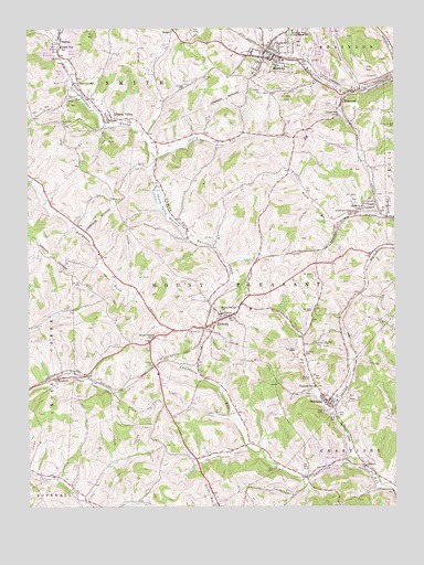
Midway, PA USGS Topographic Map
Click on map above to begin viewing in our Map Viewer.

This topographic map contains these locations and features:
Feature Name Type Latitude Longitude GNIS ID View Map
Acheson TunnelTunnelN40.3162°W80.2837°1168040View Map
BonnymeadePopulated PlaceN40.3623°W80.3581°1169983View Map
Borough of MidwayCivilN40.3687°W80.2912°1215672View Map
BrevardPopulated PlaceN40.2617°W80.2678°1212444View Map
Bulger Post OfficePost OfficeN40.3742°W80.3238°2431852View Map
Cataney AirportAirportN40.3734°W80.2998°1193960View Map
Center CemeteryCemeteryN40.3588°W80.2949°1171424View Map
Cherry Hills Inn Golf CourseLocaleN40.3462°W80.2726°1205570View Map
Cherry RunStreamN40.3412°W80.3312°1171657View Map
Cherry ValleyPopulated PlaceN40.3506°W80.3484°1171678View Map
Cherry ValleyValleyN40.3503°W80.3478°1171680View Map
Cherry Valley CemeteryCemeteryN40.3504°W80.3640°1171684View Map
Cherry Valley DamDamN40.3334°W80.3315°1194733View Map
Cherry Valley ReservoirReservoirN40.3281°W80.3281°1171686View Map
ExportPopulated PlaceN40.2606°W80.2603°1198227View Map
Fort Cherry Ambulance ServiceBuildingN40.3585°W80.2610°2719465View Map
George SchoolSchoolN40.3523°W80.2689°1175528View Map
HickoryPopulated PlaceN40.2990°W80.3087°1176948View Map
Hickory Census Designated PlaceCensusN40.2957°W80.3051°2584469View Map
Hickory Post OfficePost OfficeN40.2965°W80.3250°2431894View Map
Hickory SchoolSchoolN40.3003°W80.3092°1176977View Map
Hickory TunnelTunnelN40.2970°W80.3148°1176981View Map
HicktonPopulated PlaceN40.3712°W80.3634°1176988View Map
Krepps Covered BridgeBridgeN40.3408°W80.3311°2740716View Map
Lofferts Airport (historical)AirportN40.3609°W80.3045°1193953View Map
McGugin TunnelTunnelN40.2867°W80.3317°1180724View Map
MidwayPopulated PlaceN40.3692°W80.2928°1181083View Map
Midway Post OfficePost OfficeN40.3683°W80.2919°2431910View Map
Midway Volunteer Fire DepartmentBuildingN40.3683°W80.2899°2645012View Map
Millers RunStreamN40.3262°W80.2542°1201487View Map
Monticello FarmLocaleN40.2669°W80.3711°2708347View Map
Mount Pleasant ChurchChurchN40.3012°W80.3095°1181816View Map
Mount Pleasant Township Volunteer Fire Company Station 41BuildingN40.2986°W80.3111°2645244View Map
Mount Prospect ChurchChurchN40.2942°W80.3326°1181834View Map
PrimrosePopulated PlaceN40.3556°W80.2678°1184414View Map
Robinson Township Consolidated SchoolSchoolN40.3742°W80.2842°1185237View Map
Smith Township Police DepartmentBuildingN40.3507°W80.3424°2430770View Map
Smith Township SchoolSchoolN40.3701°W80.3634°1187893View Map
SouthviewPopulated PlaceN40.3278°W80.2589°1188132View Map
Southview Census Designated PlaceCensusN40.3320°W80.2560°2584513View Map
Southview SchoolSchoolN40.3270°W80.2645°1188133View Map
Township of Mount PleasantCivilN40.3040°W80.3055°1217198View Map
Township of SmithCivilN40.3740°W80.3713°1217205View Map
WestlandPopulated PlaceN40.2773°W80.2731°1191158View Map
Westland Census Designated PlaceCensusN40.2789°W80.2732°2584525View Map
Westland Post OfficePost OfficeN40.2786°W80.2737°2779786View Map
Westland RunStreamN40.2612°W80.2659°1201488View Map
Westland SchoolSchoolN40.2815°W80.2773°1191159View Map
WoodrowPopulated PlaceN40.2840°W80.3651°1211958View Map

Note: Coordinates in the location and feature list above are referenced to NAD83 datum.


Copyright (C) 2008-2024 Ryan Niemi / Sunset Dynamics ... All Rights Reserved