TopoQuest Logo
Do you find TopoQuest useful?
Help keep TopoQuest running and adding new maps/features by donating!
Bitcoin:  19c7KJd3qBynnjoSw5npx9KScwjBe4ifkT
Litecoin:  LXs6TkuXGGXo1vDsWCkWVdjQX94eUKd6ui
Home View Maps Find Maps Find Places Resources & Links


West Torrington, Connecticut Topographic Map

USGS Map Title: West Torrington, CT
USGS Map MRC: 41073G2
DRG (GeoTIFF) Download: o41073g2.tif


Neighboring USGS Topographic Map Quads:


  South Canaan, CT  
41073H3
 

  Norfolk, CT  
41073H2
 

  Winsted, CT  
41073H1
 

  Cornwall, CT  
41073G3
 

  West Torrington, CT  
41073G2
 

  Torrington, CT  
41073G1
 

  New Preston, CT  
41073F3
 

  Litchfield, CT  
41073F2
 

  Thomaston, CT  
41073F1


Map MRC Location:

N42°
W74°
N42°
W73°
H8 H7 H6 H5 H4 H3 H2 H1
G8 G7 G6 G5 G4 G3 G2 G1
F8 F7 F6 F5 F4 F3 F2 F1
E8 E7 E6 E5 E4 E3 E2 E1
D8 D7 D6 D5 D4 D3 D2 D1
C8 C7 C6 C5 C4 C3 C2 C1
B8 B7 B6 B5 B4 B3 B2 B1
A8 A7 A6 A5 A4 A3 A2 A1
N41°
W74°
N41°
W73°

West Torrington, CT USGS 1:24K Topographic Map Preview:
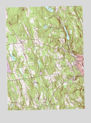
West Torrington, CT USGS Topographic Map
Click on map above to begin viewing in our Map Viewer.

This topographic map contains these locations and features:
Feature Name Type Latitude Longitude GNIS ID View Map
Allen DamDamN41.8251°W73.1599°205068View Map
Balsam Fir SwampSwampN41.8476°W73.2414°1931771View Map
Beech HillSummitN41.8668°W73.2084°205409View Map
Besse HillSummitN41.7895°W73.1487°205461View Map
Borzani ParkParkN41.7937°W73.1343°1931809View Map
Brandy HillSummitN41.8434°W73.1715°205692View Map
Brass MountainSummitN41.8607°W73.2365°205701View Map
Brush HillSummitN41.7982°W73.2187°205781View Map
Camp BirchwoodLocaleN41.8165°W73.2440°205937View Map
Camp CochipianeeLocaleN41.8098°W73.2407°205942View Map
Camp ToguamLocaleN41.8170°W73.2368°205982View Map
Charlotte Hungerford HospitalHospitalN41.7917°W73.1329°1931872View Map
Christian Apostolic ChurchChurchN41.7976°W73.1346°1931876View Map
Church Street ReservoirReservoirN41.8051°W73.1312°1770388View Map
City of TorringtonCivilN41.8349°W73.1281°2378293View Map
Collins CemeteryCemeteryN41.8238°W73.1936°206380View Map
Crystal LakeReservoirN41.8209°W73.1519°206552View Map
Crystal Lake DamDamN41.8203°W73.1509°1770379View Map
Dog PondLakeN41.8139°W73.2392°206710View Map
Drake Pond BrookStreamN41.8537°W73.1584°206734View Map
DrakevillePopulated PlaceN41.8551°W73.1573°212444View Map
Drakeville Volunteer Fire DepartmentBuildingN41.8541°W73.1573°2420453View Map
East CemeteryCemeteryN41.8434°W73.2022°206805View Map
East Litchfield Volunteer Fire CompanyBuildingN41.7608°W73.1328°2420277View Map
First Pentecostal ChurchChurchN41.8015°W73.1332°1931965View Map
Fox BrookStreamN41.8326°W73.2104°207178View Map
Friendship Baptist ChurchChurchN41.7714°W73.1742°2729780View Map
GoshenPopulated PlaceN41.8318°W73.2251°207374View Map
Goshen Academy (historical)SchoolN41.8312°W73.2243°1932002View Map
Goshen Center CemeteryCemeteryN41.8318°W73.2326°207377View Map
Goshen Center SchoolSchoolN41.8348°W73.2268°1932003View Map
Goshen Fire Marshal's OfficeBuildingN41.8345°W73.2275°2420296View Map
Goshen Historic DistrictParkN41.8320°W73.2248°1932004View Map
Goshen Historical Society BuildingBuildingN41.8315°W73.2243°1932005View Map
Goshen Historical Society LibraryBuildingN41.8315°W73.2243°1932006View Map
Goshen LibraryBuildingN41.8348°W73.2273°1932007View Map
Goshen Post OfficePost OfficeN41.8279°W73.2237°1932008View Map
Goshen Town OfficesBuildingN41.8345°W73.2273°1932009View Map
Goshen Volunteer Fire CompanyBuildingN41.8303°W73.2419°2420260View Map
Hall Meadow BrookStreamN41.8632°W73.1646°207613View Map
Hall Meadow Brook DamDamN41.8691°W73.1676°207614View Map
Hall Meadow Brook DikeDamN41.8690°W73.1609°1771600View Map
Hall Meadow Brook ReservoirReservoirN41.8736°W73.1667°207615View Map
Harry S Fisher Middle SchoolSchoolN41.8098°W73.1315°1932026View Map
Hart BrookStreamN41.8632°W73.1646°207690View Map
Hatchaloosie ReservoirReservoirN41.8404°W73.1908°1932041View Map
Hemlock Hill CampgroundLocaleN41.7870°W73.2448°1932044View Map
Hillside CemeteryCemeteryN41.7856°W73.1261°207849View Map
Ivy MountainSummitN41.8718°W73.2234°208117View Map
Ivy Mountain BrookStreamN41.8082°W73.1993°208118View Map
Ivy Mountain PondReservoirN41.8730°W73.2185°1771627View Map
Ivy Mountain Pond DamDamN41.8718°W73.2179°1771626View Map
Ivy Mountain State ParkParkN41.8720°W73.2234°208119View Map
Jakes BrookStreamN41.8643°W73.1657°208133View Map
John Browns BirthplaceLocaleN41.8393°W73.1696°208168View Map
Junior Republic of ConnecticutSchoolN41.7826°W73.2065°1932095View Map
Lake FlorenReservoirN41.7569°W73.2420°207116View Map
Lake Floren DamDamN41.7590°W73.2418°1771076View Map
Litchfield CountyCivilN41.7925°W73.2453°212796View Map
Litchfield County Center for Higher EducationBuildingN41.8407°W73.1598°1932135View Map
Litchfield County Christian ChurchChurchN41.8107°W73.1379°1932136View Map
Litchfield ReservoirReservoirN41.8127°W73.2060°208499View Map
Litchfield School for BoysSchoolN41.7640°W73.1984°208500View Map
Long SwampSwampN41.8194°W73.2241°208588View Map
Lovers Lane BrookStreamN41.8201°W73.1498°208614View Map
Lucas HillSummitN41.8495°W73.2173°208633View Map
Major Besse ParkParkN41.8170°W73.1457°1932168View Map
Maria Pratt Girl Scout CampLocaleN41.8665°W73.1815°1932172View Map
Marshall Lake BrookStreamN41.8537°W73.1554°205024View Map
Memorial HospitalHospitalN41.7918°W73.1329°208822View Map
Migeon PondReservoirN41.8483°W73.1756°208878View Map
Miscus PondLakeN41.8022°W73.1694°208968View Map
Newberry CornerPopulated PlaceN41.7893°W73.1401°209260View Map
NewfieldPopulated PlaceN41.8579°W73.1293°212519View Map
Newfield CemeteryCemeteryN41.8592°W73.1368°209266View Map
Nickel Mine BrookStreamN41.8201°W73.1457°209285View Map
Old Goshen Town HallBuildingN41.8320°W73.2248°1932269View Map
Old Middle Street CemeteryCemeteryN41.8181°W73.2208°209488View Map
Patterson PondLakeN41.8027°W73.1521°209646View Map
Peat SwampSwampN41.8358°W73.2394°209670View Map
Pie HillSummitN41.8059°W73.2068°209745View Map
Pierce Academy (historical)SchoolN41.7548°W73.1923°1932289View Map
Red MountainSummitN41.8223°W73.1332°210139View Map
Reuben Hart ReservoirReservoirN41.8726°W73.1794°210167View Map
Reuben Hart Reservoir DamDamN41.8701°W73.1707°1770377View Map
Riverside SchoolSchoolN41.8054°W73.1326°210218View Map
Saint Louis De Montfort SeminarySchoolN41.7559°W73.1768°210493View Map
Southwest SchoolSchoolN41.7951°W73.1268°211038View Map
Stillwater PondReservoirN41.8414°W73.1514°211197View Map
Stillwater Pond DamDamN41.8342°W73.1480°1770381View Map
The Forbes SchoolSchoolN41.8129°W73.1318°211415View Map
The Forman SchoolSchoolN41.7590°W73.1912°211416View Map
Torrington Country ClubLocaleN41.8309°W73.2037°212995View Map
Torrington Library University of ConnecticutBuildingN41.8407°W73.1598°1943294View Map
Town HillSummitN41.8073°W73.2329°211531View Map
Town of GoshenCivilN41.8501°W73.2336°213433View Map
Town of TorringtonCivilN41.8349°W73.1281°213517View Map
West Branch Bantam RiverStreamN41.7584°W73.1840°211921View Map
West Branch DamDamN41.8044°W73.1304°1770387View Map
West TorringtonPopulated PlaceN41.8184°W73.1437°212003View Map
West Torrington CemeteryCemeteryN41.8241°W73.1673°212004View Map
Whist PondReservoirN41.8506°W73.1863°212068View Map
Whist Pond DamDamN41.8520°W73.1834°1770389View Map
WrightvillePopulated PlaceN41.8287°W73.1490°212293View Map

Note: Coordinates in the location and feature list above are referenced to NAD83 datum.


Copyright (C) 2008-2024 Ryan Niemi / Sunset Dynamics ... All Rights Reserved