TopoQuest Logo
Do you find TopoQuest useful?
Help keep TopoQuest running and adding new maps/features by donating!
Bitcoin:  19c7KJd3qBynnjoSw5npx9KScwjBe4ifkT
Litecoin:  LXs6TkuXGGXo1vDsWCkWVdjQX94eUKd6ui
Home View Maps Find Maps Find Places Resources & Links


Westfir East, Oregon Topographic Map

USGS Map Title: Westfir East, OR
USGS Map MRC: 43122G4
DRG (GeoTIFF) Download: o43122g4.tif


Neighboring USGS Topographic Map Quads:


  Saddleblanket Mountain, OR  
43122H5
 

  Sinker Mountain, OR  
43122H4
 

  Sardine Butte, OR  
43122H3
 

  Westfir West, OR  
43122G5
 

  Westfir East, OR  
43122G4
 

  Huckleberry Mountain, OR  
43122G3
 

  Holland Point, OR  
43122F5
 

  Oakridge, OR  
43122F4
 

  McCredie Springs, OR  
43122F3


Map MRC Location:

N44°
W123°
N44°
W122°
H8 H7 H6 H5 H4 H3 H2 H1
G8 G7 G6 G5 G4 G3 G2 G1
F8 F7 F6 F5 F4 F3 F2 F1
E8 E7 E6 E5 E4 E3 E2 E1
D8 D7 D6 D5 D4 D3 D2 D1
C8 C7 C6 C5 C4 C3 C2 C1
B8 B7 B6 B5 B4 B3 B2 B1
A8 A7 A6 A5 A4 A3 A2 A1
N43°
W123°
N43°
W122°

Westfir East, OR USGS 1:24K Topographic Map Preview:
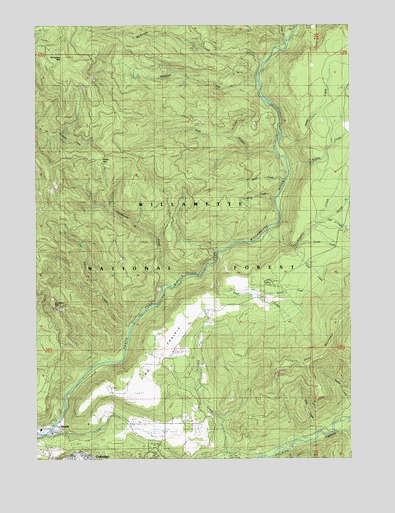
Westfir East, OR USGS Topographic Map
Click on map above to begin viewing in our Map Viewer.

This topographic map contains these locations and features:
Feature Name Type Latitude Longitude GNIS ID View Map
Alpine TrailTrailN43.8221°W122.4989°1137168View Map
Big Prairie Post Office (historical)Post OfficeN43.7682°W122.4889°1164217View Map
Buckhead MountainSummitN43.7950°W122.4949°1138851View Map
Cain Cabin TrailTrailN43.8315°W122.4428°1139138View Map
Camp SixLocaleN43.8012°W122.4095°1162604View Map
Catching ReservoirReservoirN43.7582°W122.4995°1155535View Map
Chalk CreekStreamN43.8704°W122.4025°1139552View Map
Circle Bar Golf ClubLocaleN43.7579°W122.4539°1163688View Map
Dam Number OneDamN43.7582°W122.4995°1155550View Map
Dartmouth CreekStreamN43.8001°W122.4456°1140643View Map
Davis Weber Lumber Company (historical)LocaleN43.7504°W122.3898°1699705View Map
Dead MountainSummitN43.7887°W122.3809°1140706View Map
Eighth CreekStreamN43.8332°W122.4017°1141703View Map
Fifth CreekStreamN43.8187°W122.3853°1142090View Map
First CreekStreamN43.8046°W122.4348°1142133View Map
Flat Creek Work StationLocaleN43.7512°W122.4264°1142235View Map
Forestvale CemeteryCemeteryN43.7590°W122.4359°1142302View Map
Fourth CreekStreamN43.8112°W122.3975°1142377View Map
Hamner CreekStreamN43.8582°W122.4142°1143254View Map
Hamner Creek WayTrailN43.8468°W122.4381°1143255View Map
High CreekStreamN43.8379°W122.4064°1143563View Map
High PrairieFlatN43.7835°W122.4506°1143576View Map
Huckleberry CreekStreamN43.8151°W122.4106°1143872View Map
Leapfrog CreekStreamN43.8246°W122.4070°1144905View Map
Maple CreekStreamN43.8304°W122.4028°1145792View Map
McKinley CreekStreamN43.8637°W122.4117°1146003View Map
McLane CreekStreamN43.7573°W122.4976°1135779View Map
Ninth CreekStreamN43.8426°W122.4048°1146845View Map
Oakridge State AirportAirportN43.7522°W122.4987°1154028View Map
Office BridgeBridgeN43.7585°W122.4953°1955639View Map
Salal CreekStreamN43.8387°W122.3764°1148954View Map
Scout LakeLakeN43.8749°W122.3906°1135776View Map
Second CreekStreamN43.7965°W122.4137°1149201View Map
Seventh CreekStreamN43.8176°W122.3906°1149264View Map
Short CreekStreamN43.7873°W122.4642°1149427View Map
Sixth CreekStreamN43.8235°W122.3781°1149574View Map
Slide CreekStreamN43.7573°W122.3873°1149699View Map
Sourgrass MountainSummitN43.8656°W122.4893°1149894View Map
Third CreekStreamN43.8110°W122.4020°1151059View Map
Tunnel (historical)LocaleN43.7571°W122.4889°1166259View Map
WestfirPopulated PlaceN43.7573°W122.4964°1152152View Map
Westfir City HallBuildingN43.7583°W122.4913°2661127View Map
Westfir Fire DepartmentBuildingN43.7583°W122.4913°2576974View Map
Westfir Post OfficePost OfficeN43.7576°W122.4932°1166158View Map
Westfir Water TreatmentLocaleN43.7643°W122.4923°2660830View Map
Windy PassGapN43.8360°W122.4748°1135777View Map

Note: Coordinates in the location and feature list above are referenced to NAD83 datum.


Copyright (C) 2008-2024 Ryan Niemi / Sunset Dynamics ... All Rights Reserved