TopoQuest Logo
Do you find TopoQuest useful?
Help keep TopoQuest running and adding new maps/features by donating!
Bitcoin:  19c7KJd3qBynnjoSw5npx9KScwjBe4ifkT
Litecoin:  LXs6TkuXGGXo1vDsWCkWVdjQX94eUKd6ui
Home View Maps Find Maps Find Places Resources & Links


Westfir West, Oregon Topographic Map

USGS Map Title: Westfir West, OR
USGS Map MRC: 43122G5
DRG (GeoTIFF) Download: o43122g5.tif


Neighboring USGS Topographic Map Quads:


  Fall Creek Lake, OR  
43122H6
 

  Saddleblanket Mountain, OR  
43122H5
 

  Sinker Mountain, OR  
43122H4
 

  Mount June, OR  
43122G6
 

  Westfir West, OR  
43122G5
 

  Westfir East, OR  
43122G4
 

  Rose Hill, OR  
43122F6
 

  Holland Point, OR  
43122F5
 

  Oakridge, OR  
43122F4


Map MRC Location:

N44°
W123°
N44°
W122°
H8 H7 H6 H5 H4 H3 H2 H1
G8 G7 G6 G5 G4 G3 G2 G1
F8 F7 F6 F5 F4 F3 F2 F1
E8 E7 E6 E5 E4 E3 E2 E1
D8 D7 D6 D5 D4 D3 D2 D1
C8 C7 C6 C5 C4 C3 C2 C1
B8 B7 B6 B5 B4 B3 B2 B1
A8 A7 A6 A5 A4 A3 A2 A1
N43°
W123°
N43°
W122°

Westfir West, OR USGS 1:24K Topographic Map Preview:
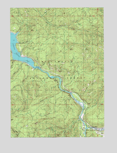
Westfir West, OR USGS Topographic Map
Click on map above to begin viewing in our Map Viewer.

This topographic map contains these locations and features:
Feature Name Type Latitude Longitude GNIS ID View Map
Armet (historical)Populated PlaceN43.8296°W122.6151°1166249View Map
Armet CreekStreamN43.8315°W122.6131°1137292View Map
Black CanyonValleyN43.7998°W122.5595°1135774View Map
Black Canyon Boat RampLocaleN43.8079°W122.5660°2668268View Map
Black Canyon Recreation SiteLocaleN43.8065°W122.5667°1138188View Map
Blackcanyon WayValleyN43.7998°W122.5614°1117788View Map
Bridge CreekStreamN43.7948°W122.5559°1138608View Map
Buckhead CreekStreamN43.7926°W122.5414°1138849View Map
Buckhead Trail Recreation SiteLocaleN43.7801°W122.5239°1156349View Map
Burnt Bridge CreekStreamN43.7898°W122.5362°1138980View Map
Cabin CreekStreamN43.8457°W122.6178°1153369View Map
Cabin CreekStreamN43.8573°W122.5526°1139107View Map
Cabin Creek TrailTrailN43.8660°W122.5531°1139110View Map
Cain CreekStreamN43.8412°W122.6153°1139139View Map
Carpet Hill CreekStreamN43.8182°W122.5912°1139389View Map
City of WestfirCivilN43.7579°W122.5093°2412234View Map
Cloverpatch ButteSummitN43.8359°W122.5463°1139859View Map
Cloverpatch CreekStreamN43.8082°W122.5609°1153400View Map
Cloverpatch TrailTrailN43.8232°W122.5576°1139860View Map
Deception CreekStreamN43.7673°W122.5337°1140775View Map
Dell CreekStreamN43.7923°W122.5456°1140876View Map
Duval CreekStreamN43.8196°W122.5995°1141449View Map
Green MountainSummitN43.8525°W122.6000°1143042View Map
HamptonLocaleN43.8201°W122.6012°1143256View Map
Hampton Boat RampLocaleN43.8162°W122.5885°2697260View Map
Hampton Park (historical)ParkN43.8179°W122.6012°1162175View Map
Hampton Recreation SiteLocaleN43.8151°W122.5956°1167099View Map
Harper CreekStreamN43.8348°W122.6245°1143317View Map
HemlockLocaleN43.7585°W122.5131°1166662View Map
Hospital CreekStreamN43.8173°W122.5867°1143829View Map
Joes PeakSummitN43.8696°W122.5521°1144297View Map
Kreuger RockPillarN43.7637°W122.5918°1144708View Map
Landax (historical)LocaleN43.7957°W122.5512°1154262View Map
Landax Post Office (historical)Post OfficeN43.7957°W122.5512°1165514View Map
Lawler (historical)LocaleN43.8221°W122.5970°1166255View Map
Lone Wolf ShelterLocaleN43.7693°W122.6167°1135775View Map
LookoutLocaleN43.7815°W122.5226°1145458View Map
Lookout PointCliffN43.7960°W122.5456°1158329View Map
Monterica CreekStreamN43.8668°W122.5845°1146397View Map
North CreekStreamN43.8251°W122.6223°1146895View Map
North Fork Middle Fork Willamette RiverStreamN43.7585°W122.5242°1146981View Map
Old Barnard BridgeBridgeN43.7549°W122.5268°1162174View Map
Prairie Camp ShelterLocaleN43.7529°W122.6109°1147973View Map
Rock CreekStreamN43.8123°W122.5773°1148570View Map
Rock KnobSummitN43.7885°W122.5952°1156737View Map
School CreekStreamN43.8510°W122.6156°1149128View Map
Schweitzer CreekStreamN43.8229°W122.6092°1149153View Map
Shady Dell Recreation SiteLocaleN43.7876°W122.5417°1149274View Map
Sourgrass TrailTrailN43.8460°W122.5548°1149896View Map
South CreekStreamN43.8260°W122.6203°1149916View Map
South Fork ShelterLocaleN43.8560°W122.5526°1150012View Map
Sweeney CreekStreamN43.8082°W122.5651°1130621View Map
Tire CreekStreamN43.7957°W122.5534°1151280View Map
Tire MountainSummitN43.8355°W122.5261°1151281View Map
Tire Mountain TrailTrailN43.8462°W122.5737°1151282View Map
Westfir Wastewater Treatment PlantLocaleN43.7593°W122.5215°2660709View Map
Westridge Middle SchoolSchoolN43.7589°W122.5289°1152153View Map
Whitehead CreekStreamN43.7954°W122.5581°1152257View Map
Willamette National Forest Middlefork Ranger DistrictBuildingN43.7586°W122.5334°1156369View Map

Note: Coordinates in the location and feature list above are referenced to NAD83 datum.


Copyright (C) 2008-2024 Ryan Niemi / Sunset Dynamics ... All Rights Reserved