TopoQuest Logo
Do you find TopoQuest useful?
Help keep TopoQuest running and adding new maps/features by donating!
Bitcoin:  19c7KJd3qBynnjoSw5npx9KScwjBe4ifkT
Litecoin:  LXs6TkuXGGXo1vDsWCkWVdjQX94eUKd6ui
Home View Maps Find Maps Find Places Resources & Links


Oakridge, Oregon Topographic Map

USGS Map Title: Oakridge, OR
USGS Map MRC: 43122F4
DRG (GeoTIFF) Download: o43122f4.tif


Neighboring USGS Topographic Map Quads:


  Westfir West, OR  
43122G5
 

  Westfir East, OR  
43122G4
 

  Huckleberry Mountain, OR  
43122G3
 

  Holland Point, OR  
43122F5
 

  Oakridge, OR  
43122F4
 

  McCredie Springs, OR  
43122F3
 

  Bearbones Mountain, OR  
43122E5
 

  Warner Mountain, OR  
43122E4
 

  Groundhog Mountain, OR  
43122E3


Map MRC Location:

N44°
W123°
N44°
W122°
H8 H7 H6 H5 H4 H3 H2 H1
G8 G7 G6 G5 G4 G3 G2 G1
F8 F7 F6 F5 F4 F3 F2 F1
E8 E7 E6 E5 E4 E3 E2 E1
D8 D7 D6 D5 D4 D3 D2 D1
C8 C7 C6 C5 C4 C3 C2 C1
B8 B7 B6 B5 B4 B3 B2 B1
A8 A7 A6 A5 A4 A3 A2 A1
N43°
W123°
N43°
W122°

Oakridge, OR USGS 1:24K Topographic Map Preview:
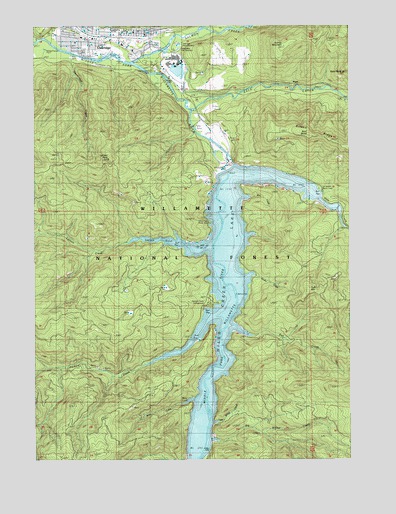
Oakridge, OR USGS Topographic Map
Click on map above to begin viewing in our Map Viewer.

This topographic map contains these locations and features:
Feature Name Type Latitude Longitude GNIS ID View Map
Aubrey MountainSummitN43.7433°W122.4022°1137338View Map
Aubrey Mountain AirstripAirportN43.7424°W122.4282°2645998View Map
Baby RockPillarN43.7364°W122.3790°1137373View Map
Bald ButteSummitN43.7181°W122.3904°1137436View Map
Big Willow CreekStreamN43.6307°W122.4325°1138097View Map
Bull CreekStreamN43.6640°W122.4245°1138895View Map
C T Beach Boat RampLocaleN43.7017°W122.3874°2668208View Map
City of OakridgeCivilN43.7451°W122.4640°2411297View Map
Cline Clark Recreation SiteLocaleN43.6929°W122.4289°1156733View Map
CT Beach Recreation SiteLocaleN43.7029°W122.3881°1135149View Map
Davis-Weber Lumber Company (historical)LocaleN43.7464°W122.4553°1166253View Map
Department of Motor Vehicles OakridgeBuildingN43.7453°W122.4819°2661349View Map
Flat CreekStreamN43.7482°W122.4292°1142231View Map
Greenwater Park Siuslaw Bank AmphitheatreLocaleN43.7382°W122.4580°2661616View Map
Greenwaters ParkParkN43.7371°W122.4553°1156445View Map
Hills CreekStreamN43.7076°W122.4234°1143605View Map
Hills Creek DamDamN43.7082°W122.4262°1158290View Map
Hills Creek LakeReservoirN43.6711°W122.4259°1158881View Map
Larison CoveBayN43.6882°W122.4539°1135148View Map
Larison Cove Canoe-In Recreation SiteLocaleN43.6890°W122.4625°1926271View Map
Larison CreekStreamN43.6862°W122.4306°1144829View Map
Larison RockPillarN43.7115°W122.4716°1144831View Map
Little Willow CreekStreamN43.6360°W122.4317°1145285View Map
Modoc CreekStreamN43.6798°W122.4250°1146381View Map
OakridgePopulated PlaceN43.7465°W122.4617°1166689View Map
Oakridge / Estfir Wastewater Treatment FacilityLocaleN43.7430°W122.4967°2660662View Map
Oakridge City HallBuildingN43.7473°W122.4571°2661392View Map
Oakridge Elementary SchoolSchoolN43.7485°W122.4651°2463023View Map
Oakridge Fire DepartmentBuildingN43.7463°W122.4852°2576636View Map
Oakridge Fish HatcheryLocaleN43.7443°W122.4437°1135147View Map
Oakridge High SchoolSchoolN43.7487°W122.4690°2463025View Map
Oakridge Justice CenterBuildingN43.7449°W122.4816°2661128View Map
Oakridge LibraryBuildingN43.7475°W122.4571°2661590View Map
Oakridge Pioneer MuseumBuildingN43.7471°W122.4600°2661183View Map
Oakridge Police DepartmentBuildingN43.7474°W122.4571°2737653View Map
Oakridge Post OfficePost OfficeN43.7475°W122.4590°1165728View Map
Oakridge Public Works ShopBuildingN43.7462°W122.4730°2661601View Map
Oregon State Police Department OakridgeBuildingN43.7448°W122.4438°2737881View Map
Ornoname 17 DamDamN43.7382°W122.4445°1163820View Map
Packard CreekStreamN43.6718°W122.4212°1147331View Map
Packard Creek Boat RampLocaleN43.6680°W122.4335°2668484View Map
Packard Creek Recreation SiteLocaleN43.6665°W122.4317°1158666View Map
PryorLocaleN43.7335°W122.3981°1148022View Map
Rigdon District Ranger Office (historical)LocaleN43.7485°W122.4387°1156442View Map
Salmon CreekStreamN43.7393°W122.4614°1148972View Map
Salmon Creek ParkParkN43.7429°W122.4539°1162171View Map
Salt CreekStreamN43.7254°W122.4378°1148998View Map
Shortridge CreekStreamN43.7418°W122.4864°1135145View Map
Stony CoveBayN43.6421°W122.4400°1135150View Map
Stony CreekStreamN43.6451°W122.4337°1150452View Map
T V ButteSummitN43.7445°W122.4243°1156735View Map
Tiptop Post Office (historical)Post OfficeN43.7068°W122.3989°1164732View Map
Tufti MountainSummitN43.6739°W122.3923°1151483View Map
Tumble CreekStreamN43.7282°W122.3753°1151502View Map
Way CreekStreamN43.7054°W122.4239°1151977View Map
West Oak Post Office (historical)Post OfficeN43.7471°W122.4817°1164776View Map
Willamette CityPopulated PlaceN43.7462°W122.4848°1152379View Map
Willamette Fish HatcheryLocaleN43.7429°W122.4442°1135146View Map
Willamette Fish Hatchery and MuseumBuildingN43.7424°W122.4451°2661633View Map

Note: Coordinates in the location and feature list above are referenced to NAD83 datum.


Copyright (C) 2008-2024 Ryan Niemi / Sunset Dynamics ... All Rights Reserved