TopoQuest Logo
Do you find TopoQuest useful?
Help keep TopoQuest running and adding new maps/features by donating!
Bitcoin:  19c7KJd3qBynnjoSw5npx9KScwjBe4ifkT
Litecoin:  LXs6TkuXGGXo1vDsWCkWVdjQX94eUKd6ui
Home View Maps Find Maps Find Places Resources & Links


Westover, Tennessee Topographic Map

USGS Map Title: Westover, TN
USGS Map MRC: 35088E8
DRG (GeoTIFF) Download: o35088e8.tif


Neighboring USGS Topographic Map Quads:


  Bells, TN  
35089F1
 

  Adair, TN  
35088F8
 

  Jackson North, TN  
35088F7
 

  Denmark, TN  
35089E1
 

  Westover, TN  
35088E8
 

  Jackson South, TN  
35088E7
 

  Mercer, TN  
35089D1
 

  Teague, TN  
35088D8
 

  Medon, TN  
35088D7


Map MRC Location:

N36°
W89°
N36°
W88°
H8 H7 H6 H5 H4 H3 H2 H1
G8 G7 G6 G5 G4 G3 G2 G1
F8 F7 F6 F5 F4 F3 F2 F1
E8 E7 E6 E5 E4 E3 E2 E1
D8 D7 D6 D5 D4 D3 D2 D1
C8 C7 C6 C5 C4 C3 C2 C1
B8 B7 B6 B5 B4 B3 B2 B1
A8 A7 A6 A5 A4 A3 A2 A1
N35°
W89°
N35°
W88°

Westover, TN USGS 1:24K Topographic Map Preview:
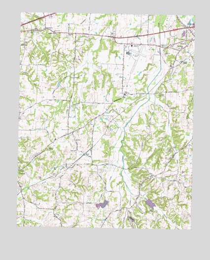
Westover, TN USGS Topographic Map
Click on map above to begin viewing in our Map Viewer.

This topographic map contains these locations and features:
Feature Name Type Latitude Longitude GNIS ID View Map
Andrews ChapelChurchN35.6129°W88.9740°1275746View Map
Ararat ChurchChurchN35.6129°W88.9656°1304864View Map
Blairs ChapelChurchN35.5104°W88.9051°1277651View Map
Blairs SchoolSchoolN35.5304°W88.9051°1277652View Map
Burkitt SidingLocaleN35.5981°W88.8834°1279056View Map
Camp BonsonLocaleN35.5451°W88.9778°1279370View Map
Cerro Gardo ChurchChurchN35.5795°W88.8995°1305835View Map
Commissioner District 7CivilN35.5504°W88.9656°2464630View Map
Denmark Elementary SchoolSchoolN35.5254°W88.9990°1321005View Map
Dry BranchStreamN35.5206°W88.9184°1282881View Map
Golden SchoolSchoolN35.5792°W88.9170°1285593View Map
Hart CreekStreamN35.5459°W88.9270°1287045View Map
HuntersvillePopulated PlaceN35.6154°W88.9823°1288754View Map
Huntersville Division (historical)CensusN35.5756°W88.9953°1648853View Map
Huntersville School (historical)SchoolN35.6142°W88.9756°1321023View Map
Johnson Creek Dam FourDamN35.5184°W88.9351°1301894View Map
Johnson Creek Dam SevenDamN35.5551°W88.8917°1301920View Map
Johnson Creek Dam TenDamN35.5051°W88.9184°1301878View Map
Johnson Creek Lake FourReservoirN35.5184°W88.9351°1301895View Map
Johnson Creek Lake SevenReservoirN35.5551°W88.8917°1301919View Map
Johnson Creek Lake TenReservoirN35.5055°W88.9175°1301879View Map
Lackey CreekStreamN35.5759°W88.9070°1290440View Map
Lane ChapelChurchN35.6151°W88.9901°1290605View Map
Lane Chapel CemeteryCemeteryN35.6142°W88.9926°1290606View Map
Little Johnson CreekStreamN35.5117°W88.9209°1291548View Map
Madison County Fire Department Station 16BuildingN35.5568°W88.9649°2654018View Map
Madison County Fire Department Station 5BuildingN35.6088°W88.8886°2654027View Map
Madison County Home (historical)BuildingN35.6109°W88.8823°1321039View Map
Mc Kellar-Sipes Regional AirportAirportN35.6024°W88.9214°1301353View Map
Mount Olive ChurchChurchN35.5512°W88.9592°1294704View Map
NeelyPopulated PlaceN35.5429°W88.9528°1295321View Map
Neely SchoolSchoolN35.5454°W88.9587°1295328View Map
Oak GrovePopulated PlaceN35.6056°W88.8959°1312113View Map
Oak Grove CemeteryCemeteryN35.6026°W88.8959°1296070View Map
Oak Grove ChurchChurchN35.6059°W88.8842°1296092View Map
Oak Grove SchoolSchoolN35.6067°W88.8964°1296126View Map
Pope ParkParkN35.6126°W88.8801°1321061View Map
Upper Ingram SchoolSchoolN35.6073°W88.9976°1273301View Map
West High SchoolSchoolN35.5781°W88.9245°1304474View Map
WestoverPopulated PlaceN35.6109°W88.8767°1274254View Map
Westover Baptist ChurchChurchN35.6098°W88.8773°1321079View Map
Westover School (historical)SchoolN35.6070°W88.8801°1321080View Map

Note: Coordinates in the location and feature list above are referenced to NAD83 datum.


Copyright (C) 2008-2025 Ryan Niemi / Sunset Dynamics ... All Rights Reserved