TopoQuest Logo
Do you find TopoQuest useful?
Help keep TopoQuest running and adding new maps/features by donating!
Bitcoin:  19c7KJd3qBynnjoSw5npx9KScwjBe4ifkT
Litecoin:  LXs6TkuXGGXo1vDsWCkWVdjQX94eUKd6ui
Home View Maps Find Maps Find Places Resources & Links


Teague, Tennessee Topographic Map

USGS Map Title: Teague, TN
USGS Map MRC: 35088D8
DRG (GeoTIFF) Download: o35088d8.tif


Neighboring USGS Topographic Map Quads:


  Denmark, TN  
35089E1
 

  Westover, TN  
35088E8
 

  Jackson South, TN  
35088E7
 

  Mercer, TN  
35089D1
 

  Teague, TN  
35088D8
 

  Medon, TN  
35088D7
 

  Bolivar West, TN  
35089C1
 

  Bolivar East, TN  
35088C8
 

  Silerton, TN  
35088C7


Map MRC Location:

N36°
W89°
N36°
W88°
H8 H7 H6 H5 H4 H3 H2 H1
G8 G7 G6 G5 G4 G3 G2 G1
F8 F7 F6 F5 F4 F3 F2 F1
E8 E7 E6 E5 E4 E3 E2 E1
D8 D7 D6 D5 D4 D3 D2 D1
C8 C7 C6 C5 C4 C3 C2 C1
B8 B7 B6 B5 B4 B3 B2 B1
A8 A7 A6 A5 A4 A3 A2 A1
N35°
W89°
N35°
W88°

Teague, TN USGS 1:24K Topographic Map Preview:
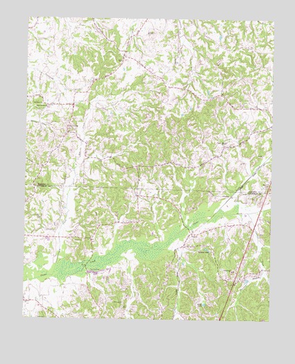
Teague, TN USGS Topographic Map
Click on map above to begin viewing in our Map Viewer.

This topographic map contains these locations and features:
Feature Name Type Latitude Longitude GNIS ID View Map
Antioch ChurchChurchN35.3820°W88.9995°1275799View Map
Bean CreekStreamN35.4101°W88.9823°1276538View Map
Bethlehem ChurchChurchN35.4642°W88.9920°1277167View Map
Butler LakeLakeN35.3815°W88.9083°1279189View Map
Clover Creek CemeteryCemeteryN35.4256°W88.8831°1280771View Map
Cobb CreekStreamN35.4881°W88.9162°1280825View Map
Commissioner District 8CivilN35.3858°W88.9781°2464676View Map
Cypress CreekStreamN35.4195°W88.8870°1281927View Map
Dry CreekStreamN35.3929°W88.9856°1282910View Map
Eberneezer ChurchChurchN35.4076°W88.9665°1283486View Map
Holland LakeReservoirN35.4043°W88.9073°1288064View Map
Johnson Creek Dam TwoDamN35.4934°W88.9217°1301872View Map
Johnson Creek Lake TwoReservoirN35.4934°W88.9217°1301873View Map
Maple Springs ChurchChurchN35.4634°W88.9898°1292637View Map
Marshall ChapelChurchN35.4487°W88.9006°1292758View Map
Marshall School (historical)SchoolN35.4473°W88.8995°1321046View Map
Medon ChurchChurchN35.4323°W88.8764°1293535View Map
Medon Division (historical)CensusN35.4904°W88.9159°1648855View Map
New Union ChurchChurchN35.3954°W88.8945°1295660View Map
Pugh CreekStreamN35.4059°W88.9301°1298657View Map
Sandy CreekStreamN35.4187°W88.9026°1300746View Map
Sweeton BranchStreamN35.3954°W88.8784°1271979View Map
Tate CemeteryCemeteryN35.3801°W88.9495°1272149View Map
TeaguePopulated PlaceN35.4109°W88.9153°1304031View Map
Toone CemeteryCemeteryN35.3754°W88.9889°1272774View Map
UptonvillePopulated PlaceN35.4548°W88.9790°1273314View Map
Vernon CemeteryCemeteryN35.4076°W88.9701°1273426View Map
Yarbrough CemeteryCemeteryN35.3820°W88.9495°1275236View Map

Note: Coordinates in the location and feature list above are referenced to NAD83 datum.


Copyright (C) 2008-2025 Ryan Niemi / Sunset Dynamics ... All Rights Reserved