TopoQuest Logo
Do you find TopoQuest useful?
Help keep TopoQuest running and adding new maps/features by donating!
Bitcoin:  19c7KJd3qBynnjoSw5npx9KScwjBe4ifkT
Litecoin:  LXs6TkuXGGXo1vDsWCkWVdjQX94eUKd6ui
Home View Maps Find Maps Find Places Resources & Links


Westover, Virginia Topographic Map

USGS Map Title: Westover, VA
USGS Map MRC: 37077C2
DRG (GeoTIFF) Download: o37077c2.tif


Neighboring USGS Topographic Map Quads:


  Dutch Gap, VA  
37077D3
 

  Roxbury, VA  
37077D2
 

  Providence Forge, VA  
37077D1
 

  Hopewell, VA  
37077C3
 

  Westover, VA  
37077C2
 

  Charles City, VA  
37077C1
 

  Prince George, VA  
37077B3
 

  Disputanta North, VA  
37077B2
 

  Savedge, VA  
37077B1


Map MRC Location:

N38°
W78°
N38°
W77°
H8 H7 H6 H5 H4 H3 H2 H1
G8 G7 G6 G5 G4 G3 G2 G1
F8 F7 F6 F5 F4 F3 F2 F1
E8 E7 E6 E5 E4 E3 E2 E1
D8 D7 D6 D5 D4 D3 D2 D1
C8 C7 C6 C5 C4 C3 C2 C1
B8 B7 B6 B5 B4 B3 B2 B1
A8 A7 A6 A5 A4 A3 A2 A1
N37°
W78°
N37°
W77°

Westover, VA USGS 1:24K Topographic Map Preview:
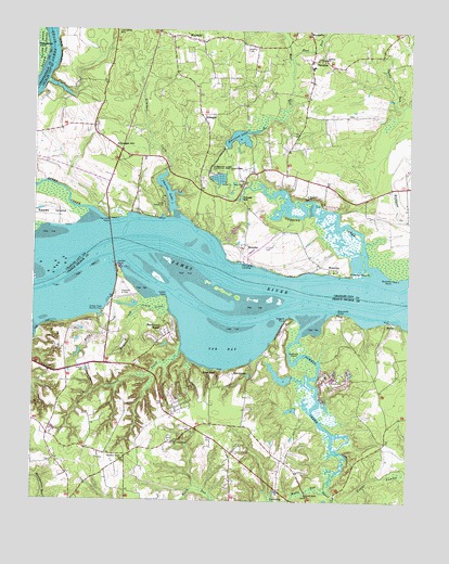
Westover, VA USGS Topographic Map
Click on map above to begin viewing in our Map Viewer.

This topographic map contains these locations and features:
Feature Name Type Latitude Longitude GNIS ID View Map
BarnettsPopulated PlaceN37.3671°W77.1578°1478146View Map
Beaver Castle Mobile Home ParkPopulated PlaceN37.2899°W77.2094°1739861View Map
BeechwoodPopulated PlaceN37.2838°W77.1828°1499106View Map
Beechwood ManorPopulated PlaceN37.2935°W77.2061°1499109View Map
Benjamin Harrison Memorial BridgeBridgeN37.3190°W77.2241°1739752View Map
BerkeleyPopulated PlaceN37.3182°W77.1794°1499121View Map
Berkeley PlantationParkN37.3175°W77.1805°2520212View Map
Bermuda Run Education CenterSchoolN37.2618°W77.2414°2465136View Map
Bickers CreekStreamN37.3013°W77.2150°1463295View Map
Billy CreekStreamN37.3013°W77.2147°1463440View Map
BlairsPopulated PlaceN37.2974°W77.1308°1499145View Map
Bucklers PointCapeN37.3093°W77.1300°1478287View Map
Camp WeyanokeLocaleN37.3288°W77.2061°1478313View Map
Chappell CreekStreamN37.2896°W77.2005°1464748View Map
Charles LakeReservoirN37.3323°W77.2055°1489441View Map
Charles Lake DamDamN37.3271°W77.2033°1489440View Map
Coggins PointCapeN37.2988°W77.1641°1465057View Map
Ducking Stool PointCapeN37.3101°W77.1455°1478510View Map
East RunStreamN37.3676°W77.1647°1478526View Map
Edgewood PlantationLocaleN37.3390°W77.1822°1739759View Map
Eelbank PointCapeN37.2882°W77.1628°1466193View Map
Enochs DamDamN37.2818°W77.1630°1490729View Map
Eppes CreekStreamN37.3271°W77.2308°1478564View Map
Evelynton HeightsSummitN37.3299°W77.1511°1739761View Map
Evelynton PlantationLocaleN37.3293°W77.1533°1739762View Map
Evergreen PlantationLocaleN37.2951°W77.2358°1739883View Map
Freetown (historical)Populated PlaceN37.3701°W77.1319°1739764View Map
Gillfield ChurchChurchN37.3676°W77.1533°1478651View Map
Hardens BluffCliffN37.3690°W77.2416°1478725View Map
Harrison DamDamN37.3446°W77.1864°1489438View Map
Harrison Grove CemeteryCemeteryN37.2607°W77.2197°1739893View Map
Harrison Grove ChurchChurchN37.2607°W77.2194°1467791View Map
Harrison LakeReservoirN37.3466°W77.1818°1479574View Map
Harrison Lake National Fish HatcheryParkN37.3390°W77.1874°1491164View Map
Harrison PointCapeN37.3246°W77.2247°1478730View Map
Harrisons LandingLocaleN37.3135°W77.1797°1499530View Map
Harrisons PointCapeN37.3146°W77.1858°1739766View Map
HaxallPopulated PlaceN37.3726°W77.2439°1480069View Map
Henshaw AirportAirportN37.2639°W77.1657°2675631View Map
Herring CreekStreamN37.3115°W77.1355°1478745View Map
Indian PointCapeN37.3040°W77.2053°1468477View Map
James River National Wildlife RefugeParkN37.2762°W77.1322°2765346View Map
Jenny CreekStreamN37.3004°W77.2053°1468686View Map
Jordan PointCapeN37.3129°W77.2225°1477917View Map
Jordan Point Country ClubLocaleN37.2952°W77.2267°1491177View Map
Jordan Point ManorPopulated PlaceN37.2896°W77.2214°1739902View Map
Jordan Point MarinaLocaleN37.3121°W77.2214°1739903View Map
Jordans Point (historical)Populated PlaceN37.3071°W77.2205°1739904View Map
KimagesPopulated PlaceN37.3526°W77.1944°1478888View Map
Kimages CreekStreamN37.3376°W77.2058°1478889View Map
Kimages HillSummitN37.3440°W77.2241°1499626View Map
Kimmages WharfLocaleN37.3238°W77.1975°1739768View Map
Lamptie HillSummitN37.3743°W77.2233°1499642View Map
Maycock Plantation (historical)LocaleN37.2988°W77.1475°1739912View Map
Maycocks PointCapeN37.3001°W77.1486°1470210View Map
Merchant Hope ChurchChurchN37.2657°W77.2022°1470361View Map
Merchants Hope (historical)Populated PlaceN37.2657°W77.2028°1739913View Map
Merchants Hope CemeteryCemeteryN37.2665°W77.2039°1739914View Map
New Vine ChurchChurchN37.3340°W77.1803°1479195View Map
Nobles SwampStreamN37.2515°W77.1489°1471553View Map
Pilots Grove AirportAirportN37.3372°W77.1979°2770222View Map
Powell CreekStreamN37.2965°W77.1589°1472734View Map
Powell Creek ChurchChurchN37.2515°W77.1580°1472735View Map
River ViewLocaleN37.2835°W77.1897°1473266View Map
Rivers EdgePopulated PlaceN37.2765°W77.2011°1739936View Map
Rivers Edge Bible ChurchChurchN37.2721°W77.2036°1739937View Map
Rolands MillPopulated PlaceN37.3299°W77.1814°1499984View Map
Ruffin Ridge FarmsLocaleN37.2557°W77.2408°1739939View Map
Tar BayBayN37.2924°W77.1864°1475475View Map
Walls RunStreamN37.2538°W77.1516°1476269View Map
WaysidePopulated PlaceN37.3724°W77.1947°1479840View Map
West RunStreamN37.3499°W77.1741°1479853View Map
WestoverPopulated PlaceN37.3118°W77.1500°1500302View Map
Westover ChurchChurchN37.3313°W77.1586°1739780View Map
Westover Post Office (historical)Post OfficeN37.3118°W77.1500°1926773View Map

Note: Coordinates in the location and feature list above are referenced to NAD83 datum.


Copyright (C) 2008-2024 Ryan Niemi / Sunset Dynamics ... All Rights Reserved