TopoQuest Logo
Do you find TopoQuest useful?
Help keep TopoQuest running and adding new maps/features by donating!
Bitcoin:  19c7KJd3qBynnjoSw5npx9KScwjBe4ifkT
Litecoin:  LXs6TkuXGGXo1vDsWCkWVdjQX94eUKd6ui
Home View Maps Find Maps Find Places Resources & Links


Westport, California Topographic Map

USGS Map Title: Westport, CA
USGS Map MRC: 39123F7
DRG (GeoTIFF) Download: o39123f7.tif


Neighboring USGS Topographic Map Quads:


  Mistake Point, CA  
39123G8
 

  Hales Grove, CA  
39123G7
 

  Leggett, CA  
39123G6


  Westport, CA  
39123F7
 

  Lincoln Ridge, CA  
39123F6


  Inglenook, CA  
39123E7
 

  Dutchmans Knoll, CA  
39123E6


Map MRC Location:

N40°
W124°
N40°
W123°
H8 H7 H6 H5 H4 H3 H2 H1
G8 G7 G6 G5 G4 G3 G2 G1
F8 F7 F6 F5 F4 F3 F2 F1
E8 E7 E6 E5 E4 E3 E2 E1
D8 D7 D6 D5 D4 D3 D2 D1
C8 C7 C6 C5 C4 C3 C2 C1
B8 B7 B6 B5 B4 B3 B2 B1
A8 A7 A6 A5 A4 A3 A2 A1
N39°
W124°
N39°
W123°

Westport, CA USGS 1:24K Topographic Map Preview:
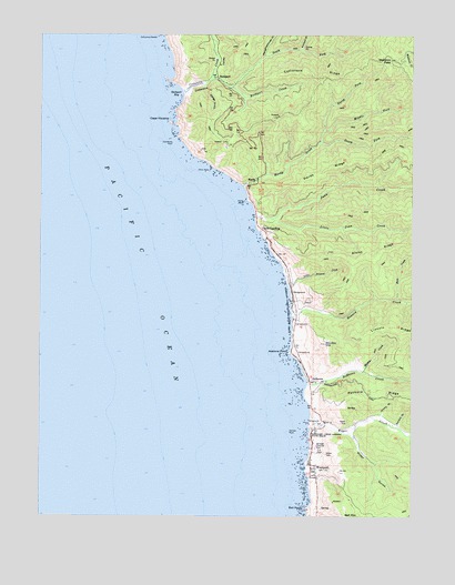
Westport, CA USGS Topographic Map
Click on map above to begin viewing in our Map Viewer.

This topographic map contains these locations and features:
Feature Name Type Latitude Longitude GNIS ID View Map
Abalone PointCapeN39.6677°W123.7920°217935View Map
Alviso RidgeRidgeN39.6935°W123.7636°218207View Map
Bell PointCapeN39.6268°W123.7864°254597View Map
Cape VizcainoCapeN39.7271°W123.8320°254710View Map
Cape Vizcaino ArchArchN39.7269°W123.8322°2710003View Map
Chris Rock IslandIslandN39.7146°W123.8186°221087View Map
Cottaneva CreekStreamN39.7360°W123.8292°254782View Map
Cottaneva NeedleIslandN39.7493°W123.8370°221621View Map
Cottaneva RidgeRidgeN39.7427°W123.7672°221622View Map
Cottaneva RockIslandN39.7218°W123.8317°254783View Map
Cottaneva ValleyValleyN39.7360°W123.8289°221623View Map
DeHavenPopulated PlaceN39.6602°W123.7850°1658380View Map
DeHaven CreekStreamN39.6590°W123.7856°222086View Map
Dodge GulchValleyN39.7368°W123.8206°222449View Map
Gordon GulchValleyN39.6482°W123.7556°260716View Map
Gordon HillSummitN39.6696°W123.7797°224340View Map
HardyPopulated PlaceN39.7124°W123.8031°1658713View Map
Hardy CreekStreamN39.7107°W123.8075°224927View Map
Hardy RidgeRidgeN39.7146°W123.7814°224928View Map
Hardy RockArchN39.7069°W123.8078°224929View Map
Howard CreekStreamN39.6779°W123.7909°225696View Map
Jimmy GulchValleyN39.6515°W123.7611°226243View Map
Juan CreekStreamN39.7029°W123.8036°226363View Map
Kimball GulchValleyN39.7463°W123.7878°234110View Map
Little Howard CreekStreamN39.6840°W123.7920°227279View Map
Little Juan CreekStreamN39.7021°W123.7978°227286View Map
Martin CreekStreamN39.6624°W123.7675°228168View Map
Middle Fork Hardy CreekStreamN39.7224°W123.7820°234288View Map
North Fork Hardy CreekStreamN39.7224°W123.7820°234371View Map
Rider CreekStreamN39.6465°W123.7725°1666814View Map
Rider GulchValleyN39.6463°W123.7722°231565View Map
Rock CreekStreamN39.6815°W123.7559°231714View Map
RockportPopulated PlaceN39.7388°W123.8161°1659534View Map
Rockport BayBayN39.7340°W123.8286°231753View Map
Rockport CreekStreamN39.7365°W123.8122°255043View Map
Rockport Fire StationLocaleN39.7221°W123.8136°231754View Map
Sea Lion RockPillarN39.7407°W123.8339°1666815View Map
Slaughterhouse GulchValleyN39.7443°W123.8009°233260View Map
South Fork Cottaneva CreekStreamN39.7388°W123.8184°1654960View Map
South Fork Hardy CreekStreamN39.7224°W123.7820°235013View Map
Switzer RockIslandN39.6465°W123.7917°235912View Map
Union LandingPopulated PlaceN39.6993°W123.8017°1660079View Map
Wages CreekStreamN39.6513°W123.7845°237147View Map
Wages Creek BeachBeachN39.6513°W123.7850°1723264View Map
Waldron PassGapN39.7435°W123.7584°237166View Map
WestportPopulated PlaceN39.6357°W123.7831°1660154View Map
Westport CemeteryCemeteryN39.6478°W123.7841°2755392View Map
Westport Post OfficePost OfficeN39.6384°W123.7847°2760069View Map
Westport Village SchoolSchoolN39.6385°W123.7836°2516059View Map
Westport Volunteer Fire DepartmentBuildingN39.6418°W123.7828°2622333View Map
Westport-Union Landing State BeachParkN39.6804°W123.7911°237565View Map

Note: Coordinates in the location and feature list above are referenced to NAD83 datum.


Copyright (C) 2008-2025 Ryan Niemi / Sunset Dynamics ... All Rights Reserved