TopoQuest Logo
Do you find TopoQuest useful?
Help keep TopoQuest running and adding new maps/features by donating!
Bitcoin:  19c7KJd3qBynnjoSw5npx9KScwjBe4ifkT
Litecoin:  LXs6TkuXGGXo1vDsWCkWVdjQX94eUKd6ui
Home View Maps Find Maps Find Places Resources & Links


Whitlash, Montana Topographic Map

USGS Map Title: Whitlash, MT
USGS Map MRC: 48111H3
DRG (GeoTIFF) Download: o48111h3.tif


Neighboring USGS Topographic Map Quads:


  Fey Lakes, MT  
48111H4
 

  Whitlash, MT  
48111H3
 

  Hawley Hill, MT  
48111H2
 

  Cameron Lake, MT  
48111G4
 

  Grassy Butte, MT  
48111G3
 

  Haystack Butte, MT  
48111G2


Map MRC Location:

N49°
W112°
N49°
W111°
H8 H7 H6 H5 H4 H3 H2 H1
G8 G7 G6 G5 G4 G3 G2 G1
F8 F7 F6 F5 F4 F3 F2 F1
E8 E7 E6 E5 E4 E3 E2 E1
D8 D7 D6 D5 D4 D3 D2 D1
C8 C7 C6 C5 C4 C3 C2 C1
B8 B7 B6 B5 B4 B3 B2 B1
A8 A7 A6 A5 A4 A3 A2 A1
N48°
W112°
N48°
W111°

Whitlash, MT USGS 1:24K Topographic Map Preview:
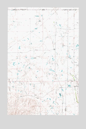
Whitlash, MT USGS Topographic Map
Click on map above to begin viewing in our Map Viewer.

This topographic map contains these locations and features:
Feature Name Type Latitude Longitude GNIS ID View Map
36N03E03CACB01 SpringSpringN48.9050°W111.3328°1636991View Map
36N03E05DACA01 SpringSpringN48.9047°W111.3647°1636990View Map
36N03E09ACCD01 SpringSpringN48.8942°W111.3478°1636947View Map
36N03E10DCAA01 WellWellN48.8886°W111.3230°1636938View Map
36N03E12DDAA01 WellWellN48.8883°W111.2736°1636937View Map
36N03E14ACDC01 WellWellN48.8783°W111.3028°1636897View Map
36N04E05BCBC01 WellWellN48.9094°W111.2508°1637010View Map
36N04E06ADDA01 WellWellN48.9089°W111.2525°1637008View Map
36N04E06ADDB01 WellWellN48.9086°W111.2530°1637005View Map
36N04E06ADDB02 WellWellN48.9086°W111.2536°1637006View Map
36N04E06DACD01 WellWellN48.9042°W111.2555°1636988View Map
36N04E06DACD02 WellWellN48.9042°W111.2555°1636989View Map
36N04E07ADDD01 WellWellN48.8928°W111.2539°1636945View Map
36N04E07DBAD01 WellWellN48.8914°W111.2586°1636942View Map
37N03E01CBCB01 WellWellN48.9917°W111.2908°1637337View Map
37N03E05CABC01 WellWellN48.9925°W111.3736°1637345View Map
37N03E11ADAA01 WellWellN48.9828°W111.2930°1637288View Map
37N03E12BCDC01 WellWellN48.9797°W111.2908°1637279View Map
37N03E12CBDD01 WellWellN48.9761°W111.2866°1637259View Map
37N03E15DADD01 WellWellN48.9620°W111.3144°1637207View Map
37N03E24ABBB01 WellWellN48.9575°W111.2794°1637192View Map
37N03E24ABBD01 WellWellN48.9561°W111.2794°1637186View Map
37N03E24ABBD02 WellWellN48.9561°W111.2786°1637185View Map
37N03E25AACA01 WellWellN48.9406°W111.2744°1637121View Map
37N03E26DABD01 WellWellN48.9342°W111.2961°1637098View Map
37N03E26DCCA01 WellWellN48.9303°W111.3003°1637086View Map
37N03E28DCCC01 WellWellN48.9317°W111.3461°1637090View Map
37N04E06BDAA01 WellWellN48.9970°W111.2591°1637357View Map
37N04E07CDDD01 WellWellN48.9725°W111.2597°1637248View Map
37N04E31CAAB01 WellWellN48.9208°W111.2611°1637054View Map
37N04E31CDAD01 WellWellN48.9161°W111.2589°1637042View Map
37N04E31CDCA01 WellWellN48.9158°W111.2628°1637040View Map
Arch Apex Gas FieldOilfieldN48.9075°W111.3589°768323View Map
Belle CreekStreamN48.9158°W111.2519°768685View Map
Brown DamDamN48.9467°W111.2675°795292View Map
Brown Diversion DamDamN48.9367°W111.2675°796696View Map
Brown RanchLocaleN48.9556°W111.2794°769282View Map
Brown ReservoirReservoirN48.9467°W111.2675°795293View Map
Camp Morris (historical)MilitaryN48.9083°W111.2522°1748633View Map
Christian DamDamN48.9417°W111.3325°795417View Map
Christian ReservoirReservoirN48.9408°W111.3320°769870View Map
Cook ReservoirReservoirN48.9845°W111.3202°770069View Map
Demarest RanchLocaleN48.9153°W111.2569°770600View Map
Demerest DamDamN48.9183°W111.2508°796699View Map
Duce CreekStreamN48.9808°W111.2922°770857View Map
Fitzpatrick LakeLakeN48.8985°W111.2830°771409View Map
Four CornersLocaleN48.9070°W111.2811°771551View Map
Hay CouleeValleyN48.9403°W111.3147°1749989View Map
Italion Stallion DamDamN48.9083°W111.2658°798531View Map
Keller CreekStreamN48.9197°W111.2589°772956View Map
Kent CouleeValleyN48.9786°W111.2933°1749990View Map
Morris Number 1 DamDamN48.8833°W111.2941°795421View Map
Morris ReservoirReservoirN48.8835°W111.2971°795422View Map
Multiplier DamDamN48.9667°W111.2841°798684View Map
North School (historical)SchoolN48.9508°W111.2928°774852View Map
Parsell RanchLocaleN48.8958°W111.3508°775095View Map
Port of WhitlashLocaleN48.9967°W111.2591°1748638View Map
Sears CouleeValleyN48.9403°W111.2650°776318View Map
Simmons CouleeValleyN48.9431°W111.2741°776564View Map
Spring CouleeValleyN48.9445°W111.2994°1749988View Map
Trail CreekStreamN48.9808°W111.2922°777737View Map
Two Turtle DamDamN48.9350°W111.3058°798685View Map
United States Customs and Border Protection Whitlash Port of EntryBuildingN48.9962°W111.2595°2738257View Map
WhitlashPopulated PlaceN48.9083°W111.2530°778432View Map
Whitlash CemeteryCemeteryN48.9086°W111.2708°778433View Map
Whitlash Post OfficePost OfficeN48.9084°W111.2519°1748617View Map
Whitlash Presbyterian Church (historical)ChurchN48.9083°W111.2530°1748567View Map
Whitlash SchoolSchoolN48.9094°W111.2514°1748685View Map

Note: Coordinates in the location and feature list above are referenced to NAD83 datum.


Copyright (C) 2008-2025 Ryan Niemi / Sunset Dynamics ... All Rights Reserved