TopoQuest Logo
Do you find TopoQuest useful?
Help keep TopoQuest running and adding new maps/features by donating!
Bitcoin:  19c7KJd3qBynnjoSw5npx9KScwjBe4ifkT
Litecoin:  LXs6TkuXGGXo1vDsWCkWVdjQX94eUKd6ui
Home View Maps Find Maps Find Places Resources & Links


Westpoint, Tennessee Topographic Map

USGS Map Title: Westpoint, TN
USGS Map MRC: 35087B5
DRG (GeoTIFF) Download: o35087b5.tif


Neighboring USGS Topographic Map Quads:


  Waynesboro East, TN  
35087C6
 

  Ovilla, TN  
35087C5
 

  Deerfield, TN  
35087C4
 

  Collinwood, TN  
35087B6
 

  Westpoint, TN  
35087B5
 

  Long Branch, TN  
35087B4
 

  Whitten, TN  
35087A6
 

  Saint Joseph, TN  
35087A5
 

  Loretto, TN  
35087A4


Map MRC Location:

N36°
W88°
N36°
W87°
H8 H7 H6 H5 H4 H3 H2 H1
G8 G7 G6 G5 G4 G3 G2 G1
F8 F7 F6 F5 F4 F3 F2 F1
E8 E7 E6 E5 E4 E3 E2 E1
D8 D7 D6 D5 D4 D3 D2 D1
C8 C7 C6 C5 C4 C3 C2 C1
B8 B7 B6 B5 B4 B3 B2 B1
A8 A7 A6 A5 A4 A3 A2 A1
N35°
W88°
N35°
W87°

Westpoint, TN USGS 1:24K Topographic Map Preview:
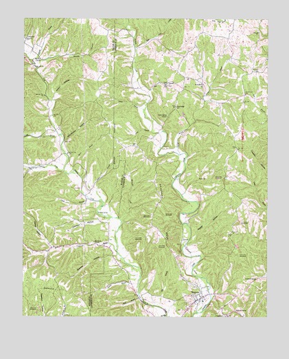
Westpoint, TN USGS Topographic Map
Click on map above to begin viewing in our Map Viewer.

This topographic map contains these locations and features:
Feature Name Type Latitude Longitude GNIS ID View Map
Aaron BranchStreamN35.1931°W87.5456°1275413View Map
Adams BranchStreamN35.2326°W87.6211°1269294View Map
Ball BranchStreamN35.2192°W87.5617°1276229View Map
BethlehemPopulated PlaceN35.1556°W87.5875°1646833View Map
Bethlehem CemeteryCemeteryN35.1562°W87.5892°1641753View Map
Bethlehem ChurchChurchN35.1565°W87.5889°1305162View Map
Boarding House HillSummitN35.1592°W87.5431°1641938View Map
Boshear CemeteryCemeteryN35.1573°W87.5811°1641757View Map
Bryson BranchStreamN35.1345°W87.5656°1278762View Map
Burkett MineMineN35.1690°W87.5100°1641940View Map
California BranchStreamN35.1520°W87.5770°1269412View Map
Cedar Spring ChurchChurchN35.2092°W87.5514°1280097View Map
Couch BranchStreamN35.1751°W87.5922°1269498View Map
Darnell School (historical)SchoolN35.1545°W87.6097°1302732View Map
Davis BranchStreamN35.1865°W87.5997°1282117View Map
Dial CemeteryCemeteryN35.2192°W87.6145°1641785View Map
Dishongh SpringSpringN35.1274°W87.5163°1282489View Map
Dodd MineMineN35.1584°W87.5678°1641943View Map
Double BranchStreamN35.2015°W87.6064°1269533View Map
Double Branch School (historical)SchoolN35.1995°W87.6167°1302739View Map
Drake MineMineN35.1612°W87.5295°1641944View Map
Gallaher CemeteryCemeteryN35.2420°W87.6242°1285094View Map
Gambrel ProspectMineN35.1287°W87.6175°1302747View Map
Grancer HollowValleyN35.1509°W87.5772°1285816View Map
Greenhall SpringSpringN35.1409°W87.5056°1286171View Map
Gresham MineMineN35.1284°W87.6167°1641807View Map
Happy HollowValleyN35.1551°W87.5413°1286759View Map
Hardwick SubdivisionPopulated PlaceN35.1312°W87.5356°1308176View Map
Hessemer Number One MineMineN35.1529°W87.5570°1641945View Map
Hessemer Number Two MineMineN35.1526°W87.5497°1641946View Map
Hopkins ProspectMineN35.1629°W87.5572°1303010View Map
Ironsides MineMineN35.1467°W87.5145°1641948View Map
John McGee HollowValleyN35.1981°W87.6043°1289486View Map
Johnson HollowValleyN35.1658°W87.5798°1289608View Map
Keaton HollowValleyN35.1537°W87.6105°1269698View Map
Kelly CemeteryCemeteryN35.2392°W87.6192°1641833View Map
Kimble BranchStreamN35.1256°W87.5517°1290166View Map
Little Hill MineMineN35.1687°W87.5481°1641950View Map
LodiPopulated PlaceN35.2226°W87.5525°1315426View Map
Lopps Chapel (historical)ChurchN35.2209°W87.5431°1303023View Map
Luker BranchStreamN35.1737°W87.5850°1292268View Map
MacDonald-Robinson ProspectMineN35.1967°W87.5678°1303025View Map
McCrory CreekStreamN35.1654°W87.5750°1293214View Map
McCrory School (historical)SchoolN35.1795°W87.5900°1302775View Map
Melton HollowValleyN35.2165°W87.6106°1293572View Map
Mount Zion ChurchChurchN35.2337°W87.6175°1294977View Map
Old West Point CemeteryCemeteryN35.1342°W87.5370°1642015View Map
PinkneyPopulated PlaceN35.1570°W87.5436°1315725View Map
Pinkney CemeteryCemeteryN35.1554°W87.5439°1642019View Map
Pinkney MineMineN35.1579°W87.5472°1641952View Map
Pouring SpringSpringN35.1687°W87.5873°1298378View Map
Prince BranchStreamN35.2115°W87.5634°1298538View Map
Red BranchStreamN35.1292°W87.5553°1299040View Map
Reed Patch CreekStreamN35.2379°W87.5678°1299151View Map
Robinson BranchStreamN35.2290°W87.6186°1299683View Map
Robinson CemeteryCemeteryN35.2284°W87.5047°1299685View Map
Rochelle CemeteryCemeteryN35.2217°W87.5325°1642022View Map
Rochelle ChurchChurchN35.2226°W87.5331°1299721View Map
Russ BranchStreamN35.1329°W87.5647°1300296View Map
Shakerag RidgeRidgeN35.1726°W87.5545°1301207View Map
Sharp MineMineN35.1645°W87.5153°1641959View Map
Shawnette CreekStreamN35.1856°W87.6045°1303550View Map
Shiloh CemeteryCemeteryN35.2004°W87.6156°1641903View Map
Silver Springs School (historical)SchoolN35.2301°W87.5703°1646871View Map
Sims RidgePopulated PlaceN35.2134°W87.5472°1314296View Map
Sims Ridge CemeteryCemeteryN35.2126°W87.5467°1642030View Map
Sims Ridge Church of ChristChurchN35.2120°W87.5467°1642031View Map
Sims Ridge School (historical)SchoolN35.2134°W87.5470°1303057View Map
Songo BranchStreamN35.2029°W87.5597°1270820View Map
Springer School (historical)SchoolN35.1342°W87.5661°1303061View Map
West Point CemeteryCemeteryN35.1284°W87.5436°1642038View Map
West Point School (historical)SchoolN35.1317°W87.5328°1317748View Map
WestpointPopulated PlaceN35.1331°W87.5336°1304494View Map
Westpoint Methodist ChurchChurchN35.1348°W87.5353°1308220View Map
Westpoint Missionary Baptist ChurchChurchN35.1342°W87.5364°1308221View Map
Westpoint Post OfficePost OfficeN35.1330°W87.5344°1649132View Map
Westpoint Volunteer Fire DepartmentBuildingN35.1340°W87.5338°2653941View Map
Wisdom CemeteryCemeteryN35.1829°W87.5311°1274897View Map
Wisdom MineMineN35.1820°W87.5222°1641960View Map
Wright MineMineN35.1542°W87.5147°1641961View Map

Note: Coordinates in the location and feature list above are referenced to NAD83 datum.


Copyright (C) 2008-2024 Ryan Niemi / Sunset Dynamics ... All Rights Reserved