TopoQuest Logo
Do you find TopoQuest useful?
Help keep TopoQuest running and adding new maps/features by donating!
Bitcoin:  19c7KJd3qBynnjoSw5npx9KScwjBe4ifkT
Litecoin:  LXs6TkuXGGXo1vDsWCkWVdjQX94eUKd6ui
Home View Maps Find Maps Find Places Resources & Links


Wiggins, South Carolina Topographic Map

USGS Map Title: Wiggins, SC
USGS Map MRC: 32080E5
DRG (GeoTIFF) Download: o32080e5.tif


Neighboring USGS Topographic Map Quads:


  White Hall, SC  
32080F6
 

  Green Pond, SC  
32080F5
 

  Fenwick, SC  
32080F4
 

  Dale, SC  
32080E6
 

  Wiggins, SC  
32080E5
 

  Bennetts Point, SC  
32080E4
 

  Beaufort, SC  
32080D6
 

  Frogmore, SC  
32080D5
 

  Saint Helena Sound, SC  
32080D4


Map MRC Location:

N33°
W81°
N33°
W80°
H8 H7 H6 H5 H4 H3 H2 H1
G8 G7 G6 G5 G4 G3 G2 G1
F8 F7 F6 F5 F4 F3 F2 F1
E8 E7 E6 E5 E4 E3 E2 E1
D8 D7 D6 D5 D4 D3 D2 D1
C8 C7 C6 C5 C4 C3 C2 C1
B8 B7 B6 B5 B4 B3 B2 B1
A8 A7 A6 A5 A4 A3 A2 A1
N32°
W81°
N32°
W80°

Wiggins, SC USGS 1:24K Topographic Map Preview:
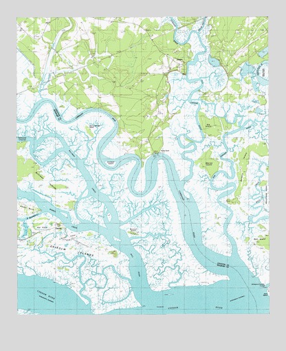
Wiggins, SC USGS Topographic Map
Click on map above to begin viewing in our Map Viewer.

This topographic map contains these locations and features:
Feature Name Type Latitude Longitude GNIS ID View Map
Ashepoo Plantation Pond Dam D-2387DamN32.6102°W80.5015°1239399View Map
Big IslandIslandN32.5791°W80.5257°1220707View Map
Bowles IslandIslandN32.5655°W80.5137°1246937View Map
Bull RiverStreamN32.5066°W80.5515°1221107View Map
Buzzard IslandIslandN32.5346°W80.5654°1221175View Map
Chehaw RiverStreamN32.5913°W80.5390°1247264View Map
ChisolmPopulated PlaceN32.5377°W80.6026°1231170View Map
Chisolm IslandsIslandN32.5294°W80.6248°1253469View Map
Chisolm PlantationLocaleN32.5363°W80.6012°1237165View Map
Combahee RiverStreamN32.5085°W80.5095°1247353View Map
Fields PointCapeN32.5688°W80.5570°1222386View Map
Fields Point School (historical)SchoolN32.5719°W80.5590°1240617View Map
Gunboat IslandIslandN32.5641°W80.5768°1245865View Map
Horse IslandIslandN32.5324°W80.6001°1223317View Map
New Chehaw RiverStreamN32.5235°W80.5165°1224964View Map
Oak IslandIslandN32.5369°W80.6120°1225124View Map
Old Chehaw RiverStreamN32.5552°W80.5418°1225171View Map
Old Combahee IslandIslandN32.5788°W80.5895°1225172View Map
Social Hall CreekStreamN32.6188°W80.5340°1226743View Map
South Wimbee CreekStreamN32.5441°W80.6109°1226772View Map
Summerhouse PointCapeN32.5244°W80.5754°1251070View Map
Tar BluffCliffN32.5849°W80.5779°1227036View Map
Warren IslandIslandN32.5632°W80.5304°1251327View Map
Whitsell LandingLocaleN32.5382°W80.6015°1237422View Map
WigginsPopulated PlaceN32.6046°W80.5437°1231924View Map
Wiggins School (historical)SchoolN32.6016°W80.5504°1240786View Map
Williman CreekStreamN32.5338°W80.5782°1251453View Map
Wimbee CreekStreamN32.5338°W80.5782°1251468View Map

Note: Coordinates in the location and feature list above are referenced to NAD83 datum.


Copyright (C) 2008-2025 Ryan Niemi / Sunset Dynamics ... All Rights Reserved