TopoQuest Logo
Do you find TopoQuest useful?
Help keep TopoQuest running and adding new maps/features by donating!
Bitcoin:  19c7KJd3qBynnjoSw5npx9KScwjBe4ifkT
Litecoin:  LXs6TkuXGGXo1vDsWCkWVdjQX94eUKd6ui
Home View Maps Find Maps Find Places Resources & Links


Green Pond, South Carolina Topographic Map

USGS Map Title: Green Pond, SC
USGS Map MRC: 32080F5
DRG (GeoTIFF) Download: o32080f5.tif


Neighboring USGS Topographic Map Quads:


  Hendersonville, SC  
32080G6
 

  Neyles, SC  
32080G5
 

  Jacksonboro, SC  
32080G4
 

  White Hall, SC  
32080F6
 

  Green Pond, SC  
32080F5
 

  Fenwick, SC  
32080F4
 

  Dale, SC  
32080E6
 

  Wiggins, SC  
32080E5
 

  Bennetts Point, SC  
32080E4


Map MRC Location:

N33°
W81°
N33°
W80°
H8 H7 H6 H5 H4 H3 H2 H1
G8 G7 G6 G5 G4 G3 G2 G1
F8 F7 F6 F5 F4 F3 F2 F1
E8 E7 E6 E5 E4 E3 E2 E1
D8 D7 D6 D5 D4 D3 D2 D1
C8 C7 C6 C5 C4 C3 C2 C1
B8 B7 B6 B5 B4 B3 B2 B1
A8 A7 A6 A5 A4 A3 A2 A1
N32°
W81°
N32°
W80°

Green Pond, SC USGS 1:24K Topographic Map Preview:
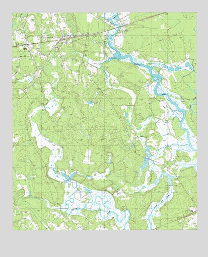
Green Pond, SC USGS Topographic Map
Click on map above to begin viewing in our Map Viewer.

This topographic map contains these locations and features:
Feature Name Type Latitude Longitude GNIS ID View Map
Airy Hall Airport (historical)AirportN32.6286°W80.5051°1251901View Map
Airy Hall Church (historical)ChurchN32.6596°W80.5176°1240542View Map
AshepooPopulated PlaceN32.7402°W80.5504°1231013View Map
Ashepoo Ferry (historical)CrossingN32.7438°W80.5565°1240544View Map
Ashepoo SidingPopulated PlaceN32.6368°W80.5007°1231015View Map
Bethel ChurchChurchN32.6432°W80.5951°1240555View Map
Bethel SchoolSchoolN32.6443°W80.5968°1220581View Map
Colleton County Fire / Rescue Green Pond RuralBuildingN32.7367°W80.5872°2368430View Map
Colleton Fire Department Station 6BuildingN32.7354°W80.5906°2368227View Map
Ebenezer ChurchChurchN32.6546°W80.5848°1222211View Map
Ebenezer ChurchChurchN32.6318°W80.5909°1240610View Map
Ebenezer ChurchChurchN32.6799°W80.5470°1240611View Map
Green PondPopulated PlaceN32.7318°W80.6143°1245829View Map
Green Pond ChurchChurchN32.7263°W80.6062°1240630View Map
Green Pond Post OfficePost OfficeN32.7315°W80.6142°2489833View Map
Horseshoe CreekStreamN32.7471°W80.5582°1223346View Map
Ivenia Brown Elementary School (historical)SchoolN32.7270°W80.6059°1240654View Map
Lavington PlantationLocaleN32.6952°W80.5215°1240666View Map
Maybank PlantationLocaleN32.7091°W80.5557°1240674View Map
Minkey IslandIslandN32.6560°W80.5318°1224596View Map
Mount Olive ChurchChurchN32.7316°W80.5923°1224743View Map
Poco Sabo PlantationLocaleN32.7241°W80.5607°1240711View Map
Tilly IslandIslandN32.6343°W80.5718°1227139View Map
Walters StoreLocaleN32.6349°W80.5915°1227390View Map
Zion ChurchChurchN32.6299°W80.5901°1227748View Map
Zion ChurchChurchN32.7116°W80.5707°1227749View Map
Zion School (historical)SchoolN32.6780°W80.5262°1240790View Map

Note: Coordinates in the location and feature list above are referenced to NAD83 datum.


Copyright (C) 2008-2024 Ryan Niemi / Sunset Dynamics ... All Rights Reserved