TopoQuest Logo
Do you find TopoQuest useful?
Help keep TopoQuest running and adding new maps/features by donating!
Bitcoin:  19c7KJd3qBynnjoSw5npx9KScwjBe4ifkT
Litecoin:  LXs6TkuXGGXo1vDsWCkWVdjQX94eUKd6ui
Home View Maps Find Maps Find Places Resources & Links


Thornwood, West Virginia Topographic Map

USGS Map Title: Thornwood, WV
USGS Map MRC: 38079E6
DRG (GeoTIFF) Download: o38079e6.tif


Neighboring USGS Topographic Map Quads:


  Wildell, WV  
38079F7
 

  Sinks of Gandy, WV  
38079F6
 

  Spruce Knob, WV  
38079F5
 

  Durbin, WV  
38079E7
 

  Thornwood, WV  
38079E6
 

  Snowy Mountain, WV  
38079E5
 

  Green Bank, WV  
38079D7
 

  Hightown, VA  
38079D6
 

  Monterey, VA  
38079D5


Map MRC Location:

N39°
W80°
N39°
W79°
H8 H7 H6 H5 H4 H3 H2 H1
G8 G7 G6 G5 G4 G3 G2 G1
F8 F7 F6 F5 F4 F3 F2 F1
E8 E7 E6 E5 E4 E3 E2 E1
D8 D7 D6 D5 D4 D3 D2 D1
C8 C7 C6 C5 C4 C3 C2 C1
B8 B7 B6 B5 B4 B3 B2 B1
A8 A7 A6 A5 A4 A3 A2 A1
N38°
W80°
N38°
W79°

Thornwood, WV USGS 1:24K Topographic Map Preview:
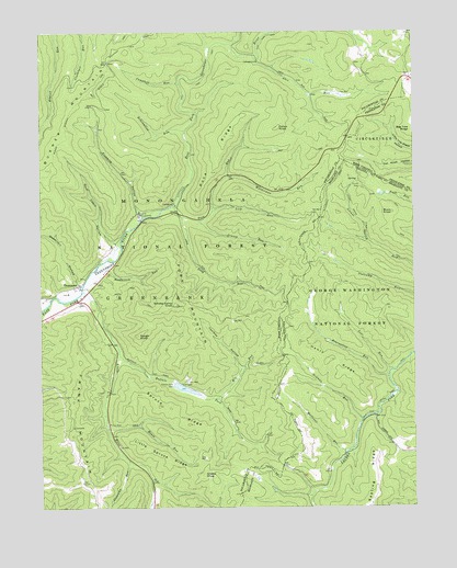
Thornwood, WV USGS Topographic Map
Click on map above to begin viewing in our Map Viewer.

This topographic map contains these locations and features:
Feature Name Type Latitude Longitude GNIS ID View Map
Abes RunStreamN38.6182°W79.6770°1550072View Map
Bearwallow RunStreamN38.5996°W79.7012°1550212View Map
Bearwallow RunStreamN38.5348°W79.6334°1481557View Map
Big RunStreamN38.5290°W79.6912°1550323View Map
Buck KnobSummitN38.5773°W79.6320°1499174View Map
Buffalo ForkStreamN38.5412°W79.7239°1550550View Map
Buffalo Fork DamDamN38.5329°W79.7053°1550543View Map
Buffalo LakeReservoirN38.5314°W79.7018°1553606View Map
Burner Mountain TrailTrailN38.5965°W79.7431°1550561View Map
Camp PocahontasLocaleN38.5773°W79.7170°1550610View Map
Campbell RunStreamN38.6115°W79.7026°1550622View Map
Colaw KnobSummitN38.5998°W79.6703°1554172View Map
Dunlevie Methodist Church (historical)ChurchN38.5565°W79.7403°1727948View Map
East Fork TrailTrailN38.6190°W79.6923°1551014View Map
Fivemile HollowValleyN38.5787°W79.7167°1551125View Map
Fork MountainSummitN38.5534°W79.7042°1554489View Map
Frank MountainSummitN38.5318°W79.7381°1551174View Map
Grassy KnobSummitN38.5090°W79.6959°1554596View Map
Grassy RunStreamN38.5757°W79.6964°1551277View Map
Gum Cabin HollowValleyN38.5704°W79.7251°1551311View Map
Henry RidgeRidgeN38.5376°W79.6512°1484043View Map
Island CampgroundLocaleN38.5804°W79.7045°1553608View Map
Lick RunStreamN38.5779°W79.6923°1551792View Map
Little RiverStreamN38.5568°W79.7362°1551885View Map
Little Spruce RidgeRidgeN38.5148°W79.7103°1551894View Map
Locust Spring Run TrailTrailN38.5673°W79.6334°1485026View Map
Locust Springs Picnic AreaLocaleN38.5848°W79.6417°1488589View Map
Locust Springs Recreation SiteLocaleN38.5873°W79.6442°1488592View Map
Long RunStreamN38.5768°W79.7026°1551925View Map
Lost RunStreamN38.5360°W79.6323°1485092View Map
Max Roth Kugel Tree PlantationLocaleN38.5568°W79.7309°1553609View Map
Mullenax RunStreamN38.6218°W79.6853°1552264View Map
Mullenax RunStreamN38.5143°W79.6481°1485752View Map
Newman RunStreamN38.5226°W79.6426°1485866View Map
Old House RunStreamN38.5212°W79.7273°1552380View Map
Old House Run Picnic AreaLocaleN38.5301°W79.7276°1553607View Map
Old House Run Recreation AreaParkN38.5215°W79.7392°1727972View Map
Poca RidgeRidgeN38.5929°W79.6895°1552515View Map
Poca RunStreamN38.5790°W79.7048°1552516View Map
Rambottom RunStreamN38.5640°W79.7306°1552582View Map
Reservoir HollowValleyN38.5596°W79.7376°1552633View Map
Rough KnobSummitN38.5457°W79.7170°1552738View Map
Sapling RidgeRidgeN38.5079°W79.6381°1486941View Map
Slabcamp RunStreamN38.5126°W79.7206°1552915View Map
Smoke Camp KnobSummitN38.5534°W79.7042°1552942View Map
Spruce RidgeRidgeN38.5265°W79.7067°1553022View Map
ThornwoodPopulated PlaceN38.5584°W79.7370°1555805View Map
Thornwood Community ChurchChurchN38.5565°W79.7403°1727981View Map
Toolbox HollowValleyN38.5368°W79.6834°1553249View Map
Walderman RunStreamN38.5873°W79.6867°1553356View Map

Note: Coordinates in the location and feature list above are referenced to NAD83 datum.


Copyright (C) 2008-2025 Ryan Niemi / Sunset Dynamics ... All Rights Reserved