TopoQuest Logo
Do you find TopoQuest useful?
Help keep TopoQuest running and adding new maps/features by donating!
Bitcoin:  19c7KJd3qBynnjoSw5npx9KScwjBe4ifkT
Litecoin:  LXs6TkuXGGXo1vDsWCkWVdjQX94eUKd6ui
Home View Maps Find Maps Find Places Resources & Links


Durbin, West Virginia Topographic Map

USGS Map Title: Durbin, WV
USGS Map MRC: 38079E7
DRG (GeoTIFF) Download: o38079e7.tif


Neighboring USGS Topographic Map Quads:


  Mill Creek, WV  
38079F8
 

  Wildell, WV  
38079F7
 

  Sinks of Gandy, WV  
38079F6
 

  Snyder Knob, WV  
38079E8
 

  Durbin, WV  
38079E7
 

  Thornwood, WV  
38079E6
 

  Cass, WV  
38079D8
 

  Green Bank, WV  
38079D7
 

  Hightown, VA  
38079D6


Map MRC Location:

N39°
W80°
N39°
W79°
H8 H7 H6 H5 H4 H3 H2 H1
G8 G7 G6 G5 G4 G3 G2 G1
F8 F7 F6 F5 F4 F3 F2 F1
E8 E7 E6 E5 E4 E3 E2 E1
D8 D7 D6 D5 D4 D3 D2 D1
C8 C7 C6 C5 C4 C3 C2 C1
B8 B7 B6 B5 B4 B3 B2 B1
A8 A7 A6 A5 A4 A3 A2 A1
N38°
W80°
N38°
W79°

Durbin, WV USGS 1:24K Topographic Map Preview:
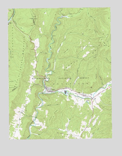
Durbin, WV USGS Topographic Map
Click on map above to begin viewing in our Map Viewer.

This topographic map contains these locations and features:
Feature Name Type Latitude Longitude GNIS ID View Map
BartowPopulated PlaceN38.5412°W79.7842°1550176View Map
Bartow - Frank - Durbin Fire and Rescue 1BuildingN38.5477°W79.8283°2577985View Map
Bartow Census Designated PlaceCensusN38.5422°W79.7858°2586758View Map
Bartow Post OfficePost OfficeN38.5429°W79.7889°1727939View Map
Bethel CemeteryCemeteryN38.5137°W79.8626°1727940View Map
Bethel United Methodist ChurchChurchN38.5140°W79.8626°1550275View Map
Blister RunStreamN38.6159°W79.8712°1550386View Map
BraucherPopulated PlaceN38.5987°W79.8206°1553967View Map
Brush RunStreamN38.5071°W79.8492°1550500View Map
Brush Run School (historical)SchoolN38.5007°W79.7895°1727944View Map
BurnerPopulated PlaceN38.6171°W79.8070°1554032View Map
Burner MountainSummitN38.5882°W79.7564°1550560View Map
Burns Lower Farm Lake DamDamN38.5334°W79.7798°1559226View Map
Camp Bartow (historical)LocaleN38.5376°W79.7678°1727946View Map
Cheat BridgeLocaleN38.6118°W79.8742°1550676View Map
Cherry Grove School (historical)SchoolN38.5098°W79.8662°1727947View Map
Cool SpringSpringN38.5807°W79.8414°1558082View Map
Coopers Rock Water Supply DamDamN38.5001°W79.7981°1559157View Map
DurbinPopulated PlaceN38.5457°W79.8251°1550996View Map
Durbin Grade School (historical)SchoolN38.5459°W79.8217°1727950View Map
Durbin Post OfficePost OfficeN38.5475°W79.8287°1727951View Map
Durbin Public LibraryBuildingN38.5455°W79.8236°2727361View Map
Durbin Water SpringSpringN38.5515°W79.8498°1558090View Map
Early SpringSpringN38.5543°W79.8456°1558091View Map
East Fork Greenbrier RiverStreamN38.5437°W79.8320°1551013View Map
Elk CreekStreamN38.5207°W79.8428°1551028View Map
Fill RunStreamN38.5804°W79.8231°1551106View Map
Fill Run School (historical)SchoolN38.5787°W79.8414°1727952View Map
FrankPopulated PlaceN38.5484°W79.8056°1554501View Map
Frank African Methodist Episcopal ChurchChurchN38.5482°W79.8098°1727953View Map
Frank Census Designated PlaceCensusN38.5462°W79.8079°2586806View Map
Gaudineer KnobSummitN38.6154°W79.8442°1554541View Map
Gaudineer Knob Lookout TowerTowerN38.6151°W79.8437°1727955View Map
Gaudineer Knob Recreation SiteParkN38.6162°W79.8448°1558767View Map
Goodsell CemeteryCemeteryN38.5437°W79.7876°1551253View Map
Grassy RidgeRidgeN38.5834°W79.8039°1551276View Map
Grassy Ridge School (historical)SchoolN38.5865°W79.7853°1727959View Map
Greenbank DistrictCivilN38.5062°W79.8026°1928281View Map
Greenbrier District Ranger StationLocaleN38.5415°W79.7781°1553672View Map
Hauchen CemeteryCemeteryN38.5573°W79.8017°1551390View Map
Hawchen HollowValleyN38.5504°W79.7587°1551391View Map
Hoover School (historical)SchoolN38.5448°W79.8506°1727961View Map
Johns RunStreamN38.5434°W79.8003°1551591View Map
Keller CemeteryCemeteryN38.5409°W79.7998°1551629View Map
Lake BuffaloReservoirN38.5334°W79.7931°1559221View Map
Lake Buffalo DamDamN38.5334°W79.7931°1559220View Map
Laurel RunStreamN38.5082°W79.8062°1551736View Map
Little RiverStreamN38.6159°W79.8101°1551886View Map
Little River Wildlife Management AreaParkN38.5243°W79.7926°2043535View Map
Mabel Burner Memorial BridgeBridgeN38.5563°W79.8305°2647546View Map
Mountain Lick CreekStreamN38.5634°W79.8226°1552231View Map
NottinghamPopulated PlaceN38.5182°W79.8431°1555245View Map
OlivePopulated PlaceN38.5637°W79.8201°1555266View Map
Saint Mark CemeteryCemeteryN38.5429°W79.7845°1727974View Map
Saint Mark the Evangelist Catholic ChurchChurchN38.5429°W79.7842°1727975View Map
Sandy RidgeRidgeN38.5226°W79.8212°1552802View Map
Span Oak TrailTrailN38.6098°W79.7789°1552987View Map
Spillman RunStreamN38.5329°W79.8337°1547147View Map
Tannery Truss BridgeBridgeN38.5444°W79.8200°2647547View Map
Town of DurbinCivilN38.5471°W79.8278°2390154View Map
Travellers ReposeBuildingN38.5382°W79.7734°1727983View Map
Travellers Repose Methodist Church (historical)ChurchN38.5429°W79.7842°1727984View Map
West Fork Greenbrier RiverStreamN38.5437°W79.8320°1553407View Map
Yeager CemeteryCemeteryN38.5382°W79.7712°1553529View Map

Note: Coordinates in the location and feature list above are referenced to NAD83 datum.


Copyright (C) 2008-2024 Ryan Niemi / Sunset Dynamics ... All Rights Reserved