TopoQuest Logo
Do you find TopoQuest useful?
Help keep TopoQuest running and adding new maps/features by donating!
Bitcoin:  19c7KJd3qBynnjoSw5npx9KScwjBe4ifkT
Litecoin:  LXs6TkuXGGXo1vDsWCkWVdjQX94eUKd6ui
Home View Maps Find Maps Find Places Resources & Links


Wilder, Idaho Topographic Map

USGS Map Title: Wilder, ID
USGS Map MRC: 43116F8
DRG (GeoTIFF) Download: o43116f8.tif


Neighboring USGS Topographic Map Quads:


  Owyhee, OR  
43117G1
 

  Parma, ID  
43116G8
 

  Parma SE, ID  
43116G7
 

  Adrian, OR  
43117F1
 

  Wilder, ID  
43116F8
 

  Notus, ID  
43116F7
 

  Graveyard Point, ID  
43117E1
 

  Homedale, ID  
43116E8
 

  Marsing, ID  
43116E7


Map MRC Location:

N44°
W117°
N44°
W116°
H8 H7 H6 H5 H4 H3 H2 H1
G8 G7 G6 G5 G4 G3 G2 G1
F8 F7 F6 F5 F4 F3 F2 F1
E8 E7 E6 E5 E4 E3 E2 E1
D8 D7 D6 D5 D4 D3 D2 D1
C8 C7 C6 C5 C4 C3 C2 C1
B8 B7 B6 B5 B4 B3 B2 B1
A8 A7 A6 A5 A4 A3 A2 A1
N43°
W117°
N43°
W116°

Wilder, ID USGS 1:24K Topographic Map Preview:
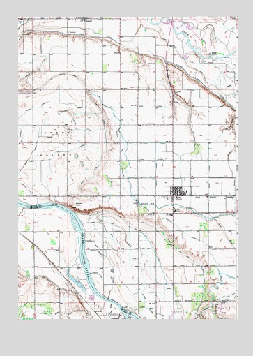
Wilder, ID USGS Topographic Map
Click on map above to begin viewing in our Map Viewer.

This topographic map contains these locations and features:
Feature Name Type Latitude Longitude GNIS ID View Map
Andrews DitchCanalN43.7429°W116.8896°371238View Map
Arena CanalCanalN43.6946°W116.9499°371283View Map
Arena Lake DrainCanalN43.7124°W116.9915°371285View Map
Attell LateralCanalN43.6835°W116.9307°371307View Map
Benson DrainCanalN43.6885°W116.8801°371459View Map
City of WilderCivilN43.6781°W116.9070°2412263View Map
Dixie Access AreaLocaleN43.7352°W116.8913°401566View Map
Dixie SloughStreamN43.7324°W116.8893°372428View Map
Drew DrainCanalN43.6557°W116.8782°372454View Map
Drew LateralCanalN43.6893°W116.8913°372455View Map
East Alkali DrainCanalN43.7477°W116.9954°372538View Map
Fargo CemeteryCemeteryN43.6499°W116.9324°372660View Map
Fargo High Line CanalCanalN43.6518°W116.9060°372661View Map
Fargo Low Line CanalCanalN43.6540°W116.9226°372662View Map
Four-H Adventure ClubSchoolN43.7488°W116.9615°401473View Map
Gem District D CanalCanalN43.6389°W116.9785°396539View Map
Goat IslandIslandN43.6496°W116.9624°372860View Map
Golden Gate CanalCanalN43.6754°W116.9335°397749View Map
Gravelly PointCliffN43.6710°W116.9671°399899View Map
Heltons IslandIslandN43.6252°W116.9349°373042View Map
Holmes Elementary SchoolSchoolN43.6791°W116.9027°401485View Map
Idaho LateralCanalN43.6979°W116.9232°373202View Map
Johnson LateralCanalN43.6268°W116.9224°373329View Map
Kilbaine LateralCanalN43.6793°W116.9315°373408View Map
Mammen GulchValleyN43.7296°W116.9154°373814View Map
Paine LateralCanalN43.6910°W116.9246°374305View Map
Parkins DrainStreamN43.6265°W116.9818°374328View Map
Patch CanalCanalN43.6424°W116.9754°374341View Map
Plowhead LateralCanalN43.6949°W116.9690°374455View Map
Ross LateralCanalN43.7129°W116.9232°374791View Map
RoswellPopulated PlaceN43.7490°W116.9618°400062View Map
Roswell CemeteryCemeteryN43.7433°W116.9711°374795View Map
Sheckard LateralCanalN43.7093°W116.9693°374978View Map
Succor CreekStreamN43.6318°W116.9463°375318View Map
Vantress LateralCanalN43.6774°W116.9377°375697View Map
Watts LateralCanalN43.7032°W116.9624°375768View Map
WilderPopulated PlaceN43.6765°W116.9118°398357View Map
Wilder CemeteryCemeteryN43.6679°W116.9232°375897View Map
Wilder DivisionCivilN43.6661°W116.8968°1936833View Map
Wilder Head StartSchoolN43.6771°W116.9085°401701View Map
Wilder Middle - High SchoolSchoolN43.6775°W116.9041°399680View Map
Wilder Police DepartmentBuildingN43.6778°W116.9097°2722470View Map
Wilder Post OfficePost OfficeN43.6755°W116.9123°2766853View Map
Wilder Rural Fire Protection DistrictBuildingN43.6765°W116.9085°2618991View Map
Wordica LateralCanalN43.7038°W116.9985°375997View Map

Note: Coordinates in the location and feature list above are referenced to NAD83 datum.


Copyright (C) 2008-2024 Ryan Niemi / Sunset Dynamics ... All Rights Reserved