TopoQuest Logo
Do you find TopoQuest useful?
Help keep TopoQuest running and adding new maps/features by donating!
Bitcoin:  19c7KJd3qBynnjoSw5npx9KScwjBe4ifkT
Litecoin:  LXs6TkuXGGXo1vDsWCkWVdjQX94eUKd6ui
Home View Maps Find Maps Find Places Resources & Links


Williams Ranch, New Mexico Topographic Map

USGS Map Title: Williams Ranch, NM
USGS Map MRC: 32107C8
DRG (GeoTIFF) Download: o32107c8.tif


Neighboring USGS Topographic Map Quads:


  Antelope Hill, NM  
32108D1
 

  Spalding, NM  
32107D8
 

  Goat Ridge, NM  
32107D7
 

  Grandmother Mountain East, NM  
32108C1
 

  Williams Ranch, NM  
32107C8
 

  Deming West, NM  
32107C7
 

  Gage, NM  
32108B1
 

  Red Mountain, NM  
32107B8
 

  Bowlin Ranch, NM  
32107B7


Map MRC Location:

N33°
W108°
N33°
W107°
H8 H7 H6 H5 H4 H3 H2 H1
G8 G7 G6 G5 G4 G3 G2 G1
F8 F7 F6 F5 F4 F3 F2 F1
E8 E7 E6 E5 E4 E3 E2 E1
D8 D7 D6 D5 D4 D3 D2 D1
C8 C7 C6 C5 C4 C3 C2 C1
B8 B7 B6 B5 B4 B3 B2 B1
A8 A7 A6 A5 A4 A3 A2 A1
N32°
W108°
N32°
W107°

Williams Ranch, NM USGS 1:24K Topographic Map Preview:
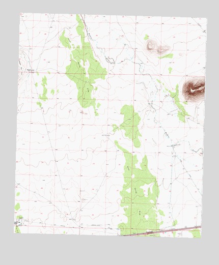
Williams Ranch, NM USGS Topographic Map
Click on map above to begin viewing in our Map Viewer.

This topographic map contains these locations and features:
Feature Name Type Latitude Longitude GNIS ID View Map
00161 Water WellWellN32.2954°W107.8939°930180View Map
00576 Water WellWellN32.2537°W107.9309°922274View Map
01240 Water WellWellN32.3468°W107.8753°922515View Map
01241 Water WellWellN32.3462°W107.8759°930169View Map
01252 Water WellWellN32.3718°W107.9587°922271View Map
01254 Water WellWellN32.3523°W107.9231°923243View Map
01356 Water WellWellN32.2556°W107.9970°922269View Map
01357 Water WellWellN32.2989°W107.9921°930182View Map
01362 Water WellWellN32.2581°W107.9620°929755View Map
01363 Water WellWellN32.2543°W107.9609°922275View Map
01364 Water WellWellN32.2548°W107.9575°922276View Map
01384 Water WellWellN32.2531°W107.9406°925403View Map
06089 Water WellWellN32.3226°W107.9228°925452View Map
06090 Water WellWellN32.3048°W107.9864°930172View Map
06091 Water WellWellN32.2970°W107.9903°930181View Map
06139 Water WellWellN32.3715°W107.9003°922272View Map
1360 Water WellWellN32.2556°W107.9970°922268View Map
1382 Water WellWellN32.2529°W107.9309°922273View Map
Black MountainSummitN32.3331°W107.8836°886436View Map
LauerMineN32.2918°W107.8964°914609View Map
M-366 Water WellWellN32.2662°W107.8753°922177View Map
Middle WellLocaleN32.3070°W107.9409°891991View Map
North WindmillLocaleN32.2962°W107.8934°892715View Map
Number 1256 Water WellWellN32.3425°W107.9912°923242View Map
South WindmillLocaleN32.2587°W107.9617°895183View Map
TunisPopulated PlaceN32.2515°W107.9178°920721View Map
Williams RanchLocaleN32.3423°W107.9917°896630View Map
WillisMineN32.3668°W107.8806°915693View Map

Note: Coordinates in the location and feature list above are referenced to NAD83 datum.


Copyright (C) 2008-2025 Ryan Niemi / Sunset Dynamics ... All Rights Reserved