TopoQuest Logo
Do you find TopoQuest useful?
Help keep TopoQuest running and adding new maps/features by donating!
Bitcoin:  19c7KJd3qBynnjoSw5npx9KScwjBe4ifkT
Litecoin:  LXs6TkuXGGXo1vDsWCkWVdjQX94eUKd6ui
Home View Maps Find Maps Find Places Resources & Links


Frankfort, Ohio Topographic Map

USGS Map Title: Frankfort, OH
USGS Map MRC: 39083D2
DRG (GeoTIFF) Download: o39083d2.tif


Neighboring USGS Topographic Map Quads:


  New Holland, OH  
39083E3
 

  Clarksburg, OH  
39083E2
 

  Williamsport, OH  
39083E1
 

  Good Hope, OH  
39083D3
 

  Frankfort, OH  
39083D2
 

  Andersonville, OH  
39083D1
 

  South Salem, OH  
39083C3
 

  Bourneville, OH  
39083C2
 

  Chillicothe West, OH  
39083C1


Map MRC Location:

N40°
W84°
N40°
W83°
H8 H7 H6 H5 H4 H3 H2 H1
G8 G7 G6 G5 G4 G3 G2 G1
F8 F7 F6 F5 F4 F3 F2 F1
E8 E7 E6 E5 E4 E3 E2 E1
D8 D7 D6 D5 D4 D3 D2 D1
C8 C7 C6 C5 C4 C3 C2 C1
B8 B7 B6 B5 B4 B3 B2 B1
A8 A7 A6 A5 A4 A3 A2 A1
N39°
W84°
N39°
W83°

Frankfort, OH USGS 1:24K Topographic Map Preview:
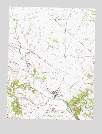
Frankfort, OH USGS Topographic Map
Click on map above to begin viewing in our Map Viewer.

This topographic map contains these locations and features:
Feature Name Type Latitude Longitude GNIS ID View Map
Adena High SchoolSchoolN39.4062°W83.1835°1049995View Map
AustinPopulated PlaceN39.4367°W83.2224°1064360View Map
Austin ChapelChurchN39.4423°W83.2307°1060838View Map
Austin Post Office (historical)Post OfficeN39.4362°W83.2221°2056631View Map
Baptist CemeteryCemeteryN39.3998°W83.1671°1963451View Map
Bethel School (historical)SchoolN39.4031°W83.2327°1050047View Map
Bowdle FarmsLocaleN39.4553°W83.1403°2726047View Map
Clark CemeteryCemeteryN39.4453°W83.1427°1963459View Map
Cline School (historical)SchoolN39.4212°W83.1413°1050054View Map
Concord Township Emergency SquadBuildingN39.4021°W83.1811°2550832View Map
Concord Township Fire DepartmentBuildingN39.4020°W83.1808°2550591View Map
Corey RunStreamN39.3915°W83.1630°1039371View Map
Dewey CreekStreamN39.3756°W83.2482°1039692View Map
Dry RunStreamN39.3792°W83.1530°1039827View Map
Egypt Church (historical)ChurchN39.4992°W83.2024°1050053View Map
Estel ChapelChurchN39.4448°W83.1674°1040235View Map
Estell School (historical)SchoolN39.4478°W83.1688°1050051View Map
Fisher School (historical)SchoolN39.3826°W83.2149°1050046View Map
Fountain School (historical)SchoolN39.4501°W83.2371°1050048View Map
FrankfortPopulated PlaceN39.4015°W83.1807°1064673View Map
Frankfort Elementary SchoolSchoolN39.4053°W83.1819°1049996View Map
Frankfort Post OfficePost OfficeN39.4015°W83.1805°2043401View Map
Grassland DairyLocaleN39.4664°W83.2269°2726049View Map
Greenland School (historical)SchoolN39.4553°W83.1360°1050055View Map
Greenlawn CemeteryCemeteryN39.4076°W83.1927°1041133View Map
Herrod CreekStreamN39.4531°W83.2330°1066747View Map
Lake HillReservoirN39.3858°W83.1535°1077738View Map
Lake Hill CampgroundLocaleN39.3845°W83.1524°1049997View Map
Lake Hill DamDamN39.3851°W83.1516°1077737View Map
Leffingwell School (historical)SchoolN39.4859°W83.1435°1050056View Map
Little CreekStreamN39.3823°W83.1574°1042658View Map
Mallow CemeteryCemeteryN39.4287°W83.2238°1042906View Map
Mallow School (historical)SchoolN39.4809°W83.2282°1050049View Map
McCortney RunStreamN39.4298°W83.2227°1043157View Map
New Bethel ChurchChurchN39.3970°W83.2352°1043824View Map
Noble School (historical)SchoolN39.4862°W83.1774°1050052View Map
Old Methodist CemeteryCemeteryN39.3992°W83.1796°1963466View Map
Oldtown RunStreamN39.3959°W83.1685°1066872View Map
Putnam Dairy FarmLocaleN39.4611°W83.2297°2516505View Map
Rowe CemeteryCemeteryN39.4642°W83.2380°1045232View Map
RoxabellPopulated PlaceN39.3848°W83.1877°1045237View Map
Roxabell Post Office (historical)Post OfficeN39.3848°W83.1874°2056666View Map
Sanford School (historical)SchoolN39.4159°W83.1974°1050050View Map
Stader CemeteryCemeteryN39.4353°W83.2185°1046616View Map
Township of ConcordCivilN39.4165°W83.2154°1086893View Map
Township of DeerfieldCivilN39.4885°W83.1602°1086894View Map
Village of FrankfortCivilN39.4047°W83.1782°2398914View Map
Ware CemeteryCemeteryN39.4909°W83.1902°1047566View Map
Wind Dreamer FarmsLocaleN39.4897°W83.2153°2726048View Map

Note: Coordinates in the location and feature list above are referenced to NAD83 datum.


Copyright (C) 2008-2024 Ryan Niemi / Sunset Dynamics ... All Rights Reserved