TopoQuest Logo
Do you find TopoQuest useful?
Help keep TopoQuest running and adding new maps/features by donating!
Bitcoin:  19c7KJd3qBynnjoSw5npx9KScwjBe4ifkT
Litecoin:  LXs6TkuXGGXo1vDsWCkWVdjQX94eUKd6ui
Home View Maps Find Maps Find Places Resources & Links


Winfield SE, Alabama Topographic Map

USGS Map Title: Winfield SE, AL
USGS Map MRC: 33087G7
DRG (GeoTIFF) Download: o33087g7.tif


Neighboring USGS Topographic Map Quads:


  Guin, AL  
33087H8
 

  Winfield, AL  
33087H7
 

  Glen Allen, AL  
33087H6
 

  Bluff, AL  
33087G8
 

  Winfield SE, AL  
33087G7
 

  Hubbertville, AL  
33087G6
 

  Belk, AL  
33087F8
 

  Fayette, AL  
33087F7
 

  Bankston, AL  
33087F6


Map MRC Location:

N34°
W88°
N34°
W87°
H8 H7 H6 H5 H4 H3 H2 H1
G8 G7 G6 G5 G4 G3 G2 G1
F8 F7 F6 F5 F4 F3 F2 F1
E8 E7 E6 E5 E4 E3 E2 E1
D8 D7 D6 D5 D4 D3 D2 D1
C8 C7 C6 C5 C4 C3 C2 C1
B8 B7 B6 B5 B4 B3 B2 B1
A8 A7 A6 A5 A4 A3 A2 A1
N33°
W88°
N33°
W87°

Winfield SE, AL USGS 1:24K Topographic Map Preview:
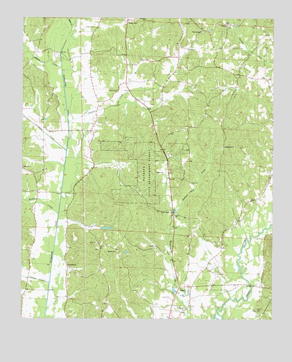
Winfield SE, AL USGS Topographic Map
Click on map above to begin viewing in our Map Viewer.

This topographic map contains these locations and features:
Feature Name Type Latitude Longitude GNIS ID View Map
Ballard CemeteryCemeteryN33.8623°W87.7928°113422View Map
Ballard School (historical)SchoolN33.8626°W87.7917°137686View Map
Bethel CemeteryCemeteryN33.8129°W87.8747°114021View Map
Bethel Church Gas FieldOilfieldN33.8026°W87.8625°154897View Map
Bethlehem Church (historical)ChurchN33.7537°W87.8072°137699View Map
Bird Nest AirportAirportN33.8656°W87.8453°2676300View Map
Bluff Springs Church (historical)ChurchN33.8201°W87.8200°137701View Map
Dodsen CreekStreamN33.8543°W87.8559°155053View Map
Dykes CemeteryCemeteryN33.8729°W87.7747°158818View Map
Elbethel CemeteryCemeteryN33.7782°W87.8278°158526View Map
Elbethel ChurchChurchN33.7779°W87.8284°117911View Map
Fayette State Experiment ForestForestN33.8107°W87.8125°118226View Map
Flat Top School (historical)SchoolN33.7721°W87.8242°137726View Map
Fowler CemeteryCemeteryN33.7537°W87.7561°118567View Map
Fowlers School (historical)SchoolN33.7657°W87.7553°137727View Map
Gibson ChurchChurchN33.7626°W87.7956°158834View Map
Gilpin CemeteryCemeteryN33.8109°W87.8045°118974View Map
Hickory Rock School (historical)SchoolN33.8273°W87.7734°137733View Map
Hodge Chapel CemeteryCemeteryN33.8729°W87.8225°158530View Map
Hodges CemeteryCemeteryN33.8712°W87.8400°120173View Map
Hodges ChapelChurchN33.8732°W87.8228°120174View Map
Hopewell CemeteryCemeteryN33.7551°W87.7964°158527View Map
Hopewell Primitive Baptist ChurchChurchN33.7551°W87.7967°120379View Map
Hopewell School (historical)SchoolN33.7546°W87.7970°137739View Map
Housh Chapel CemeteryCemeteryN33.7943°W87.8014°158528View Map
Houshs Chapel Church of ChristChurchN33.7948°W87.8014°158849View Map
Hubbert Mill CreekStreamN33.7943°W87.8000°120495View Map
Indian CreekStreamN33.7648°W87.8609°120649View Map
Jones Mill (historical)LocaleN33.7557°W87.7886°137742View Map
Killingsworth LakeReservoirN33.7551°W87.8234°131724View Map
Killingsworth Lake DamDamN33.7551°W87.8234°131723View Map
Langston CreekStreamN33.8198°W87.8531°121390View Map
Lawrence Mill Volunteer Fire DepartmentBuildingN33.7528°W87.7943°2683431View Map
Luxapallila ChurchChurchN33.7723°W87.8522°122111View Map
Mount Olive ChurchChurchN33.8745°W87.8142°123320View Map
Muskgrove Mill (historical)LocaleN33.7773°W87.8017°1958349View Map
Pine Grove Church (historical)ChurchN33.8598°W87.8411°137763View Map
Porter CemeteryCemeteryN33.7562°W87.8322°158525View Map
Sand Springs Baptist ChurchChurchN33.8218°W87.7745°153318View Map
Sand Springs CemeteryCemeteryN33.8212°W87.7753°158529View Map
Sand Springs Oil Field (historical)OilfieldN33.8209°W87.7695°154886View Map
Shirley CemeteryCemeteryN33.7687°W87.7778°126779View Map
StewartPopulated PlaceN33.8479°W87.8236°137775View Map
Stewart CemeteryCemeteryN33.8448°W87.8281°127382View Map
Stewart CreekStreamN33.8321°W87.8517°127387View Map
Studhorse Creek Gas FieldOilfieldN33.8579°W87.7584°154898View Map
Sugar CreekStreamN33.8707°W87.8509°127503View Map
Turkey CreekStreamN33.7932°W87.8567°128160View Map
Unity Baptist ChurchChurchN33.7932°W87.7989°153810View Map
Watkins LakeReservoirN33.7876°W87.8323°131747View Map
Watkins Lake DamDamN33.7884°W87.8350°131746View Map
White Springs CemeteryCemeteryN33.8695°W87.7856°158325View Map
White Springs ChurchChurchN33.8695°W87.7859°128892View Map
Winfield-Glen Allen DivisionCivilN33.8426°W87.8354°165778View Map
Zion Church (historical)ChurchN33.8729°W87.8336°137786View Map

Note: Coordinates in the location and feature list above are referenced to NAD83 datum.


Copyright (C) 2008-2024 Ryan Niemi / Sunset Dynamics ... All Rights Reserved