TopoQuest Logo
Do you find TopoQuest useful?
Help keep TopoQuest running and adding new maps/features by donating!
Bitcoin:  19c7KJd3qBynnjoSw5npx9KScwjBe4ifkT
Litecoin:  LXs6TkuXGGXo1vDsWCkWVdjQX94eUKd6ui
Home View Maps Find Maps Find Places Resources & Links


Hubbertville, Alabama Topographic Map

USGS Map Title: Hubbertville, AL
USGS Map MRC: 33087G6
DRG (GeoTIFF) Download: o33087g6.tif


Neighboring USGS Topographic Map Quads:


  Winfield, AL  
33087H7
 

  Glen Allen, AL  
33087H6
 

  Carbon Hill, AL  
33087H5
 

  Winfield SE, AL  
33087G7
 

  Hubbertville, AL  
33087G6
 

  Howard, AL  
33087G5
 

  Fayette, AL  
33087F7
 

  Bankston, AL  
33087F6
 

  Berry, AL  
33087F5


Map MRC Location:

N34°
W88°
N34°
W87°
H8 H7 H6 H5 H4 H3 H2 H1
G8 G7 G6 G5 G4 G3 G2 G1
F8 F7 F6 F5 F4 F3 F2 F1
E8 E7 E6 E5 E4 E3 E2 E1
D8 D7 D6 D5 D4 D3 D2 D1
C8 C7 C6 C5 C4 C3 C2 C1
B8 B7 B6 B5 B4 B3 B2 B1
A8 A7 A6 A5 A4 A3 A2 A1
N33°
W88°
N33°
W87°

Hubbertville, AL USGS 1:24K Topographic Map Preview:
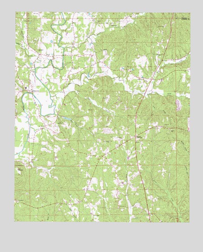
Hubbertville, AL USGS Topographic Map
Click on map above to begin viewing in our Map Viewer.

This topographic map contains these locations and features:
Feature Name Type Latitude Longitude GNIS ID View Map
Barron CreekStreamN33.8540°W87.7153°113513View Map
Berea CemeteryCemeteryN33.8493°W87.7278°158534View Map
Berea Church of ChristChurchN33.8493°W87.7275°113943View Map
Boxes CreekStreamN33.8246°W87.7245°114787View Map
Boxes Creek Gas FieldOilfieldN33.8446°W87.7070°154900View Map
Boxes Creek School (historical)SchoolN33.8404°W87.7036°137704View Map
Cedar Grove CemeteryCemeteryN33.7587°W87.6756°158536View Map
Cedar Grove ChurchChurchN33.7593°W87.6750°115790View Map
Davis ChapelChurchN33.7543°W87.6933°158811View Map
Davis Chapel CemeteryCemeteryN33.7543°W87.6933°158535View Map
Davis Chapel Gas FieldOilfieldN33.7668°W87.6833°154902View Map
Dobbs CemeteryCemeteryN33.7557°W87.6431°158309View Map
Dry CreekStreamN33.8271°W87.6567°117578View Map
Ford MountainSummitN33.7798°W87.7472°118480View Map
Fowler Crossroads Volunteer Fire DepartmentBuildingN33.7891°W87.6845°2683466View Map
Fowlers CrossroadsPopulated PlaceN33.8012°W87.6633°118575View Map
Hollingsworth CemeteryCemeteryN33.7834°W87.7433°158848View Map
Hollingsworth Mill CreekStreamN33.7907°W87.7472°137735View Map
Hubbertsville Gas FieldOilfieldN33.8246°W87.7403°154899View Map
HubbertvillePopulated PlaceN33.8279°W87.7400°120496View Map
Hubbertville CemeteryCemeteryN33.8279°W87.7408°158533View Map
Hubbertville Church of ChristChurchN33.8287°W87.7414°137741View Map
Hubbertville High SchoolSchoolN33.8298°W87.7422°165612View Map
Hubbertville Volunteer Fire DepartmentBuildingN33.8505°W87.7343°2683439View Map
Isom CreekStreamN33.8257°W87.6564°120720View Map
Little CreekStreamN33.8284°W87.7111°121759View Map
Mac-Jer DairyLocaleN33.8000°W87.7369°2611193View Map
Mayfield CemeteryCemeteryN33.8090°W87.7167°158531View Map
Mayfield ChurchChurchN33.8090°W87.7159°122422View Map
McCollum BridgeBridgeN33.8257°W87.7375°1958348View Map
McCollum CemeteryCemeteryN33.8415°W87.7092°122486View Map
Mill CreekStreamN33.8140°W87.7220°155150View Map
Morris CemeteryCemeteryN33.8740°W87.7333°123075View Map
Mount Home Baptist ChurchChurchN33.7982°W87.6628°158877View Map
New Liberty CemeteryCemeteryN33.7993°W87.6733°158537View Map
New Liberty ChurchChurchN33.7996°W87.6733°123859View Map
New Prospect CemeteryCemeteryN33.7982°W87.6820°158538View Map
New Prospect Primitive Baptist ChurchChurchN33.7979°W87.6825°152667View Map
New River Baptist ChurchChurchN33.8357°W87.6578°158852View Map
New River CemeteryCemeteryN33.8073°W87.7286°158532View Map
New River CemeteryCemeteryN33.8345°W87.6570°158539View Map
New River CemeteryCemeteryN33.8362°W87.6575°158540View Map
New River CemeteryCemeteryN33.8526°W87.6875°158541View Map
New River Church (historical)ChurchN33.8359°W87.6528°137754View Map
New River Church of ChristChurchN33.8071°W87.7284°152672View Map
New River Hunting ClubLocaleN33.8404°W87.6675°158315View Map
New River Primitive Baptist ChurchChurchN33.8526°W87.6872°158792View Map
Northeast Davis Chapel Gas FieldOilfieldN33.7932°W87.6625°154901View Map
Northeast Fayette DivisionCivilN33.8085°W87.6368°165777View Map
Phillips CemeteryCemeteryN33.8495°W87.6475°124681View Map
Rehobeth CemeteryCemeteryN33.7618°W87.7478°158321View Map
Rehobeth ChurchChurchN33.7623°W87.7470°125548View Map
Sprinkle CemeteryCemeteryN33.8695°W87.6914°158932View Map
Studhorse CreekStreamN33.8412°W87.7353°155260View Map
Thornton CemeteryCemeteryN33.8401°W87.7367°127931View Map
Tidwell CemeteryCemeteryN33.8670°W87.6436°127963View Map
Tidwell ChapelChurchN33.8671°W87.6814°158938View Map
Tidwell Chapel CemeteryCemeteryN33.8679°W87.6814°158542View Map
Turkey CreekStreamN33.8540°W87.7436°128161View Map
Wade CemeteryCemeteryN33.8170°W87.6981°128484View Map
Whitehead CemeteryCemeteryN33.8520°W87.7333°128896View Map
Wiley Hollingsworth StadiumParkN33.8294°W87.7411°2352832View Map

Note: Coordinates in the location and feature list above are referenced to NAD83 datum.


Copyright (C) 2008-2025 Ryan Niemi / Sunset Dynamics ... All Rights Reserved