TopoQuest Logo
Do you find TopoQuest useful?
Help keep TopoQuest running and adding new maps/features by donating!
Bitcoin:  19c7KJd3qBynnjoSw5npx9KScwjBe4ifkT
Litecoin:  LXs6TkuXGGXo1vDsWCkWVdjQX94eUKd6ui
Home View Maps Find Maps Find Places Resources & Links


Bulls Gap, Alabama Topographic Map

USGS Map Title: Bulls Gap, AL
USGS Map MRC: 33086B1
DRG (GeoTIFF) Download: o33086b1.tif


Neighboring USGS Topographic Map Quads:


  Winterboro, AL  
33086C2
 

  Porter Gap, AL  
33086C1
 

  Clairmont Springs, AL  
33085C8
 

  Sylacauga East, AL  
33086B2
 

  Bulls Gap, AL  
33086B1
 

  Millerville, AL  
33085B8
 

  Hollins, AL  
33086A2
 

  Goodwater, AL  
33086A1
 

  Hackneyville, AL  
33085A8


Map MRC Location:

N34°
W87°
N34°
W86°
H8 H7 H6 H5 H4 H3 H2 H1
G8 G7 G6 G5 G4 G3 G2 G1
F8 F7 F6 F5 F4 F3 F2 F1
E8 E7 E6 E5 E4 E3 E2 E1
D8 D7 D6 D5 D4 D3 D2 D1
C8 C7 C6 C5 C4 C3 C2 C1
B8 B7 B6 B5 B4 B3 B2 B1
A8 A7 A6 A5 A4 A3 A2 A1
N33°
W87°
N33°
W86°

Bulls Gap, AL USGS 1:24K Topographic Map Preview:
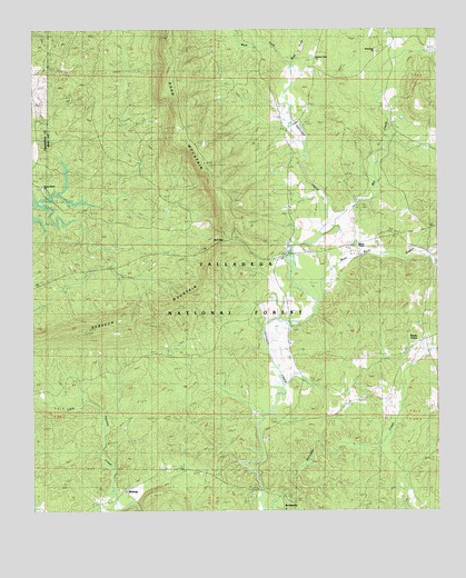
Bulls Gap, AL USGS Topographic Map
Click on map above to begin viewing in our Map Viewer.

This topographic map contains these locations and features:
Feature Name Type Latitude Longitude GNIS ID View Map
Bethlehem CemeteryCemeteryN33.2437°W86.0189°1805372View Map
Bethlehem Methodist ChurchChurchN33.2434°W86.0183°159163View Map
BrownsvillePopulated PlaceN33.1260°W86.0472°159254View Map
Bulls GapGapN33.1948°W86.0644°159270View Map
Campbell CemeteryCemeteryN33.2287°W86.0414°151034View Map
East Fork Hatchet CreekStreamN33.2409°W86.0447°159548View Map
East MillPopulated PlaceN33.1304°W86.0527°159549View Map
Faith Baptist Church of the DeafChurchN33.1854°W86.1025°162428View Map
First Baptist ChurchChurchN33.1868°W86.0991°162429View Map
First Presbyterian ChurchChurchN33.1859°W86.1011°162430View Map
GagePopulated PlaceN33.2454°W86.0008°162008View Map
Garrett ProspectMineN33.2057°W86.0322°151031View Map
Harral MineMineN33.2434°W86.0044°151029View Map
Hatcher Post Office (historical)Post OfficeN33.2357°W86.0380°166095View Map
Hatchet CreekPopulated PlaceN33.2426°W86.0416°162013View Map
Hatchett Creek Baptist ChurchChurchN33.2421°W86.0389°159734View Map
Hatchett Creek CemeteryCemeteryN33.1257°W86.0464°151116View Map
Hatchett Creek CemeteryCemeteryN33.2426°W86.0386°1805383View Map
Hatchett Creek Presbyterian ChurchChurchN33.1254°W86.0472°151036View Map
Hollins Fire TowerTowerN33.1734°W86.0886°164346View Map
Hollins Hunter CampLocaleN33.1579°W86.1241°163096View Map
Hollins Wildlife Camping AreaLocaleN33.1565°W86.1202°151033View Map
Hollins Wildlife Management AreaParkN33.2498°W86.1247°162016View Map
Hopewell Church (historical)ChurchN33.2201°W86.1180°162017View Map
Littles Mill (historical)LocaleN33.2051°W86.0255°162028View Map
Marvin ChapelChurchN33.1937°W86.0252°160045View Map
Marvin Chapel CemeteryCemeteryN33.1937°W86.0247°1805390View Map
McGehee MountainSummitN33.2296°W86.0061°160075View Map
McGhee MineMineN33.2284°W86.0169°151030View Map
MidwayPopulated PlaceN33.1304°W86.0964°160090View Map
Midway School (historical)SchoolN33.1310°W86.0966°1729895View Map
Mill CreekStreamN33.1968°W86.0352°159969View Map
Millerville-Hollins DivisionCivilN33.1899°W86.0209°165704View Map
Moss Rock BranchStreamN33.1787°W86.0361°160139View Map
Pierces MillLocaleN33.1279°W86.0511°169115View Map
Rocky Mountain ChurchChurchN33.2087°W86.1214°160526View Map
RosellePopulated PlaceN33.1857°W86.0497°160533View Map
Rozelle and Chandler CemeteryCemeteryN33.1812°W86.0508°151032View Map
Russell CemeteryCemeteryN33.2409°W86.0539°151035View Map
Shady GrovePopulated PlaceN33.1690°W86.0061°160581View Map
Shady Grove ChurchChurchN33.1693°W86.0058°163644View Map
Shoal CreekStreamN33.2062°W86.0208°169116View Map
Sommers School (historical)SchoolN33.1996°W86.0033°162044View Map
West Fork Hatchet CreekStreamN33.2407°W86.0444°160825View Map

Note: Coordinates in the location and feature list above are referenced to NAD83 datum.


Copyright (C) 2008-2024 Ryan Niemi / Sunset Dynamics ... All Rights Reserved