TopoQuest Logo
Do you find TopoQuest useful?
Help keep TopoQuest running and adding new maps/features by donating!
Bitcoin:  19c7KJd3qBynnjoSw5npx9KScwjBe4ifkT
Litecoin:  LXs6TkuXGGXo1vDsWCkWVdjQX94eUKd6ui
Home View Maps Find Maps Find Places Resources & Links


Woodford, Virginia Topographic Map

USGS Map Title: Woodford, VA
USGS Map MRC: 38077A4
DRG (GeoTIFF) Download: o38077a4.tif


Neighboring USGS Topographic Map Quads:


  Spotsylvania, VA  
38077B5
 

  Guinea, VA  
38077B4
 

  Rappahannock Academy, VA  
38077B3
 

  Ladysmith, VA  
38077A5
 

  Woodford, VA  
38077A4
 

  Bowling Green, VA  
38077A3
 

  Hewlett, VA  
37077H5
 

  Ruther Glen, VA  
37077H4
 

  Penola, VA  
37077H3


Map MRC Location:

N39°
W78°
N39°
W77°
H8 H7 H6 H5 H4 H3 H2 H1
G8 G7 G6 G5 G4 G3 G2 G1
F8 F7 F6 F5 F4 F3 F2 F1
E8 E7 E6 E5 E4 E3 E2 E1
D8 D7 D6 D5 D4 D3 D2 D1
C8 C7 C6 C5 C4 C3 C2 C1
B8 B7 B6 B5 B4 B3 B2 B1
A8 A7 A6 A5 A4 A3 A2 A1
N38°
W78°
N38°
W77°

Woodford, VA USGS 1:24K Topographic Map Preview:
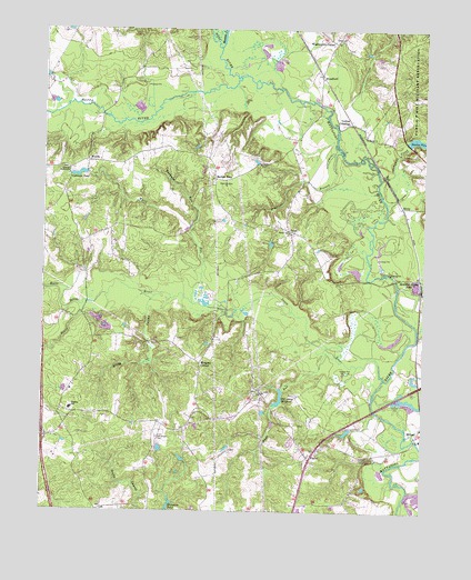
Woodford, VA USGS Topographic Map
Click on map above to begin viewing in our Map Viewer.

This topographic map contains these locations and features:
Feature Name Type Latitude Longitude GNIS ID View Map
Bethel CemeteryCemeteryN38.0722°W77.4197°1739324View Map
Bethel ChurchChurchN38.0724°W77.4191°1463196View Map
Bowies DamDamN38.0951°W77.3814°1489339View Map
Bowies PondReservoirN38.0966°W77.3771°1489340View Map
Bowling Green ParkLocaleN38.0607°W77.3761°1463716View Map
Burkes ShopLocaleN38.0860°W77.4425°1464114View Map
Campbell CreekStreamN38.0865°W77.3891°1464371View Map
Caroline High SchoolSchoolN38.0005°W77.4146°1464452View Map
Caroline Middle SchoolSchoolN38.0033°W77.4106°2465099View Map
Coleman PondReservoirN38.0874°W77.4885°1501985View Map
Coleman Pond DamDamN38.0879°W77.4858°1489369View Map
Colemans Garage DamDamN38.0885°W77.4864°1489397View Map
Collins CrossingPopulated PlaceN38.1010°W77.3989°1499285View Map
Downers BranchStreamN38.0932°W77.4022°1465925View Map
Hobby SwampStreamN38.0557°W77.4630°1468085View Map
Interchange 110CrossingN38.0190°W77.4991°1739355View Map
Ladysmith Primary SchoolSchoolN38.0265°W77.4906°2464941View Map
Lebanon TabernacleChurchN38.0887°W77.4916°1469255View Map
Madison Elementary SchoolSchoolN38.0266°W77.4903°1470006View Map
Martin PondLakeN38.0199°W77.3798°1739364View Map
Matta RiverStreamN38.1129°W77.4353°1470189View Map
Mays RunStreamN38.0412°W77.4064°1470225View Map
Meadow CreekStreamN38.1204°W77.4416°1470312View Map
Motto RiverStreamN38.0537°W77.4853°1470793View Map
Old Grays DamDamN38.0312°W77.4203°1489366View Map
Old Grays MillpondReservoirN38.0282°W77.4225°1489367View Map
PaigePopulated PlaceN38.0726°W77.4189°1499833View Map
Poni RiverStreamN38.1126°W77.4355°1472602View Map
PoplarPopulated PlaceN38.0143°W77.4119°1499893View Map
RixeyPopulated PlaceN38.0790°W77.3822°1499970View Map
Saint John School (historical)SchoolN38.0282°W77.4480°1739388View Map
Saint Johns ChurchChurchN38.0307°W77.4280°1473777View Map
Saint Marys ChurchChurchN38.0976°W77.3947°1473834View Map
South RiverStreamN38.0349°W77.3872°1474887View Map
Sunshine School (historical)SchoolN38.0729°W77.4783°1739398View Map
Tanyard RunStreamN38.0718°W77.4508°1475471View Map
Third Mount Zion ChurchChurchN38.0857°W77.4394°1475632View Map
Washington CornerPopulated PlaceN38.1218°W77.4047°1477861View Map
WelchsPopulated PlaceN38.0907°W77.4855°1500291View Map
White RunStreamN38.0543°W77.4505°1476641View Map
WoodfordPopulated PlaceN38.1132°W77.4089°1500344View Map
Woodford AirparkAirportN38.0842°W77.4830°1498595View Map
Woodford Post OfficePost OfficeN38.1122°W77.4089°2767272View Map
Woodford School (historical)SchoolN38.0618°W77.4083°1739404View Map
Wright Church (historical)ChurchN38.0226°W77.4600°1739405View Map
Wright's Burying Ground - CemeteryCemeteryN38.0191°W77.4621°1471888View Map
Wrights CornerPopulated PlaceN38.0385°W77.4475°1500075View Map

Note: Coordinates in the location and feature list above are referenced to NAD83 datum.


Copyright (C) 2008-2024 Ryan Niemi / Sunset Dynamics ... All Rights Reserved