TopoQuest Logo
Do you find TopoQuest useful?
Help keep TopoQuest running and adding new maps/features by donating!
Bitcoin:  19c7KJd3qBynnjoSw5npx9KScwjBe4ifkT
Litecoin:  LXs6TkuXGGXo1vDsWCkWVdjQX94eUKd6ui
Home View Maps Find Maps Find Places Resources & Links


Bowling Green, Virginia Topographic Map

USGS Map Title: Bowling Green, VA
USGS Map MRC: 38077A3
DRG (GeoTIFF) Download: o38077a3.tif


Neighboring USGS Topographic Map Quads:


  Guinea, VA  
38077B4
 

  Rappahannock Academy, VA  
38077B3
 

  Port Royal, VA  
38077B2
 

  Woodford, VA  
38077A4
 

  Bowling Green, VA  
38077A3
 

  Supply, VA  
38077A2
 

  Ruther Glen, VA  
37077H4
 

  Penola, VA  
37077H3
 

  Sparta, VA  
37077H2


Map MRC Location:

N39°
W78°
N39°
W77°
H8 H7 H6 H5 H4 H3 H2 H1
G8 G7 G6 G5 G4 G3 G2 G1
F8 F7 F6 F5 F4 F3 F2 F1
E8 E7 E6 E5 E4 E3 E2 E1
D8 D7 D6 D5 D4 D3 D2 D1
C8 C7 C6 C5 C4 C3 C2 C1
B8 B7 B6 B5 B4 B3 B2 B1
A8 A7 A6 A5 A4 A3 A2 A1
N38°
W78°
N38°
W77°

Bowling Green, VA USGS 1:24K Topographic Map Preview:
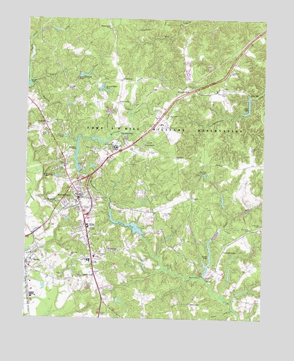
Bowling Green, VA USGS Topographic Map
Click on map above to begin viewing in our Map Viewer.

This topographic map contains these locations and features:
Feature Name Type Latitude Longitude GNIS ID View Map
A P Hill Army Airfield (Fort A P Hill)AirportN38.0697°W77.3181°2675626View Map
Acors CornerPopulated PlaceN38.0901°W77.3261°1477061View Map
Anderson Family CemeteryCemeteryN38.0282°W77.3530°1739317View Map
Ann Webster CornerLocaleN38.0943°W77.3261°1739319View Map
Antioch ForkPopulated PlaceN38.0176°W77.3378°1492477View Map
BaylortownPopulated PlaceN38.0999°W77.3241°1477100View Map
Beasley CemeteryCemeteryN38.0173°W77.2797°1739322View Map
Beaverdam PondReservoirN38.0868°W77.3315°1489372View Map
Beaverdam Pond DamDamN38.0851°W77.3314°1489371View Map
Bowling GreenPopulated PlaceN38.0496°W77.3466°1498454View Map
Bowling Green Elementary SchoolSchoolN38.0380°W77.3420°2465044View Map
Bowling Green Police DepartmentBuildingN38.0515°W77.3451°2332034View Map
Bowling Green Post OfficePost OfficeN38.0494°W77.3485°2767201View Map
Bowling Green Primary SchoolSchoolN38.0239°W77.3417°2465048View Map
BroaddusPopulated PlaceN38.0674°W77.2953°1477144View Map
Broaddus DamDamN38.0618°W77.3455°1489360View Map
Broaddus Mill (historical)LocaleN38.0610°W77.3472°1739328View Map
Broaddus PondReservoirN38.0605°W77.3443°1501963View Map
Buzzard Roost PondReservoirN38.0959°W77.3343°1501970View Map
Buzzard Roost Pond DamDamN38.0949°W77.3369°1489370View Map
Caroline CountyCivilN38.0267°W77.3470°1480107View Map
Caroline County Department of Fire / RescueBuildingN38.0518°W77.3449°2331794View Map
Caroline County Department of Fire Rescue and Emergency Management - AdministrationBuildingN38.0243°W77.3408°2331771View Map
Caroline County Fire and Rescue / Bowling Green Volunteer Fire Department Company 1BuildingN38.0515°W77.3446°2075529View Map
Caroline County Fire and Rescue / Bowling Green Volunteer Rescue Squad Rescue 1BuildingN38.0515°W77.3446°2331627View Map
Caroline County Sheriff's OfficeBuildingN38.0512°W77.3458°2331957View Map
Carters CornerPopulated PlaceN38.0499°W77.2878°1477181View Map
Cattlet CreekStreamN38.0979°W77.3733°1464570View Map
Chesapeake Bay Governors SchoolSchoolN38.0390°W77.3423°2465287View Map
Chinns RunStreamN38.0779°W77.3208°1464866View Map
D Pitts DamDamN38.0168°W77.2680°1489373View Map
DelosPopulated PlaceN38.0965°W77.2719°1492859View Map
Delos DamDamN38.0929°W77.2569°1489337View Map
Delos LakeReservoirN38.0927°W77.2578°1465725View Map
Delos PondReservoirN38.0861°W77.2594°1489338View Map
Elliots Mill (historical)LocaleN38.0349°W77.3141°1739344View Map
Elliots PondReservoirN38.0393°W77.3214°1502788View Map
Elliotts DamDamN38.0351°W77.3125°1489361View Map
Evergreen CemeteryCemeteryN38.0262°W77.3358°1466361View Map
FarmersLocaleN38.0818°W77.3653°1466490View Map
Farmers PondReservoirN38.0757°W77.3544°1466495View Map
Fort A P HillMilitaryN38.1035°W77.2659°2512521View Map
Fort A P Hill Fire DepartmentBuildingN38.0683°W77.3271°2660599View Map
Green Lawn CemeteryCemeteryN38.0705°W77.3386°1467477View Map
Hamilton PondReservoirN38.0604°W77.2815°1467684View Map
Hard CornerPopulated PlaceN38.0065°W77.2878°1477394View Map
Hicks MillPopulated PlaceN38.0940°W77.2580°1493079View Map
Honeysuckle GateLocaleN38.1210°W77.3303°1468213View Map
Howards CornerPopulated PlaceN38.0943°W77.2908°1493110View Map
Jones RunStreamN38.0043°W77.2644°1468860View Map
Lakewood CemeteryCemeteryN38.0630°W77.3465°1469105View Map
Lee Maury School (historical)SchoolN38.0468°W77.3539°1739358View Map
Lonesome Gulch DamDamN38.1001°W77.3497°1489334View Map
Lonesome Gulch PondReservoirN38.1014°W77.3457°1469749View Map
Loving ForkPopulated PlaceN38.0965°W77.3530°1477502View Map
MilfordPopulated PlaceN38.0232°W77.3733°1493287View Map
Milford Post OfficePost OfficeN38.0228°W77.3731°2767238View Map
Mount Calvary ChurchChurchN38.0260°W77.3500°1470831View Map
Peumansend Creek Regional JailBuildingN38.1117°W77.2673°2767125View Map
Poorhouse CornerPopulated PlaceN38.0285°W77.2705°1493445View Map
Range CornerPopulated PlaceN38.0721°W77.3125°1493469View Map
Raymonds ForkPopulated PlaceN38.0768°W77.3250°1493473View Map
Reynolds RunStreamN38.0990°W77.3722°1473170View Map
SmootsPopulated PlaceN38.0168°W77.2783°1493617View Map
Smoots DamDamN38.0185°W77.2805°1489336View Map
Smoots PondReservoirN38.0211°W77.2792°1502132View Map
Smoots RunStreamN38.0174°W77.2822°1474789View Map
Town of Bowling GreenCivilN38.0534°W77.3472°2390742View Map
Turkey Track CreekStreamN38.0985°W77.3733°1475964View Map
Union High SchoolSchoolN38.0246°W77.3408°1476074View Map
Virginia State Police Division 1 Area 44 OfficeBuildingN38.0493°W77.3477°2332014View Map
Wrights RunStreamN38.0760°W77.3303°1474305View Map
WrightsvillePopulated PlaceN38.0285°W77.3314°1493562View Map

Note: Coordinates in the location and feature list above are referenced to NAD83 datum.


Copyright (C) 2008-2024 Ryan Niemi / Sunset Dynamics ... All Rights Reserved