TopoQuest Logo
Do you find TopoQuest useful?
Help keep TopoQuest running and adding new maps/features by donating!
Bitcoin:  19c7KJd3qBynnjoSw5npx9KScwjBe4ifkT
Litecoin:  LXs6TkuXGGXo1vDsWCkWVdjQX94eUKd6ui
Home View Maps Find Maps Find Places Resources & Links


Scott, Arkansas Topographic Map

USGS Map Title: Scott, AR
USGS Map MRC: 34092F1
DRG (GeoTIFF) Download: o34092f1.tif


Neighboring USGS Topographic Map Quads:


  McAlmont, AR  
34092G2
 

  Jacksonville, AR  
34092G1
 

  Lonoke, AR  
34091G8
 

  Sweet Home, AR  
34092F2
 

  Scott, AR  
34092F1
 

  Pettus, AR  
34091F8
 

  Woodson, AR  
34092E2
 

  Keo, AR  
34092E1
 

  England, AR  
34091E8


Map MRC Location:

N35°
W93°
N35°
W92°
H8 H7 H6 H5 H4 H3 H2 H1
G8 G7 G6 G5 G4 G3 G2 G1
F8 F7 F6 F5 F4 F3 F2 F1
E8 E7 E6 E5 E4 E3 E2 E1
D8 D7 D6 D5 D4 D3 D2 D1
C8 C7 C6 C5 C4 C3 C2 C1
B8 B7 B6 B5 B4 B3 B2 B1
A8 A7 A6 A5 A4 A3 A2 A1
N34°
W93°
N34°
W92°

Scott, AR USGS 1:24K Topographic Map Preview:
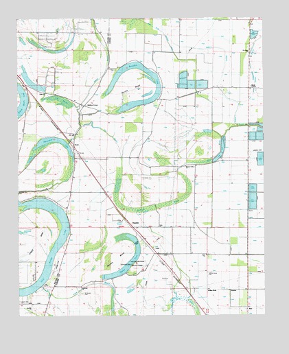
Scott, AR USGS Topographic Map
Click on map above to begin viewing in our Map Viewer.

This topographic map contains these locations and features:
Feature Name Type Latitude Longitude GNIS ID View Map
All Souls Rest CemeteryCemeteryN34.6773°W92.1249°45825View Map
Ashley BayouGutN34.7270°W92.0813°45956View Map
Bailey ChurchChurchN34.7187°W92.1104°46013View Map
Banes ChapelChurchN34.6354°W92.0176°46074View Map
Bearskin LakeLakeN34.7140°W92.0661°75635View Map
Bevis CornerPopulated PlaceN34.7206°W92.0071°76330View Map
Britt SchoolSchoolN34.7356°W92.0557°46965View Map
Bullneck BrakeSwampN34.6725°W92.0461°76464View Map
Campbells Store (historical)LocaleN34.6301°W92.1110°68131View Map
CobbsPopulated PlaceN34.6284°W92.0090°47876View Map
Country ClubPopulated PlaceN34.7295°W92.0735°61361View Map
Dooley BendBendN34.6490°W92.0754°48566View Map
Dortch BendBendN34.7220°W92.0665°48572View Map
Dortchs Store (historical)LocaleN34.7159°W92.0518°75263View Map
Dry BayouLakeN34.7057°W92.0891°76822View Map
Eanes Minnow Farm Lake Number OneReservoirN34.7218°W92.1085°79507View Map
Eanes Minnow Farm Lake Number One DamDamN34.7218°W92.1085°79506View Map
Eanes Minnow Farm Lake Number TwoReservoirN34.7238°W92.1178°79505View Map
Eanes Minnow Farm Lake Number Two DamDamN34.7201°W92.1118°79504View Map
Gates Store (historical)LocaleN34.6912°W92.0246°61369View Map
HamiterPopulated PlaceN34.6623°W92.0674°57045View Map
Hickory Grove CemeteryCemeteryN34.6431°W92.0282°50059View Map
Hickory Grove ChurchChurchN34.6506°W92.0093°50065View Map
Horseshoe LakeLakeN34.6992°W92.1073°75740View Map
Hubbs Store (historical)LocaleN34.6654°W92.0085°61367View Map
Hudgens CemeteryCemeteryN34.6315°W92.1249°50385View Map
Le Grande CemeteryCemeteryN34.6826°W92.0629°51018View Map
Luebke Fish FarmLocaleN34.6919°W92.0017°2674753View Map
Mound LakeReservoirN34.6414°W92.0823°79513View Map
Mound Lake DamDamN34.6418°W92.0818°79512View Map
Mound PondLakeN34.6466°W92.0705°77701View Map
Mount Hope ChurchChurchN34.7165°W92.0435°52302View Map
Mount Mirrah School (historical)SchoolN34.6370°W92.0929°77720View Map
Mount Moriah CemeteryCemeteryN34.6343°W92.0932°61359View Map
Mount Moriah ChurchChurchN34.6370°W92.0935°61358View Map
Mount Olive ChurchChurchN34.7281°W92.0565°52351View Map
Old River LakeLakeN34.6352°W92.1240°77912View Map
Pea Ridge CemeteryCemeteryN34.7356°W92.0074°61371View Map
Pea Ridge ChurchChurchN34.7356°W92.0071°53244View Map
Pecan Grove School (historical)SchoolN34.6284°W92.0043°61366View Map
Pleasant Grove ChurchChurchN34.7143°W92.0921°53543View Map
Pleasant Valley ChurchChurchN34.6879°W92.0396°53613View Map
R V Stewart FieldAirportN34.7427°W92.0911°83799View Map
ScottPopulated PlaceN34.6965°W92.0963°54634View Map
Scott BayouGutN34.6812°W92.1046°54635View Map
Scott Census Designated PlaceCensusN34.6967°W92.0938°2402831View Map
Scott Elementary SchoolSchoolN34.7013°W92.0986°68530View Map
Scott Volunteer Fire Department Station 18BuildingN34.6699°W92.1000°2117099View Map
Simmons CemeteryCemeteryN34.7284°W92.0749°54855View Map
Snow BrakeSwampN34.7012°W92.0249°54984View Map
Steele BendBendN34.6490°W92.1201°55190View Map
ToltecPopulated PlaceN34.6512°W92.0560°55592View Map
Toltec ChurchChurchN34.6506°W92.0293°55593View Map
Toltec ChurchChurchN34.6623°W92.0538°55594View Map
Toltec MoundsSummitN34.6470°W92.0651°58752View Map
Toltec Mounds State ParkParkN34.6459°W92.0640°61360View Map
Township of DortchCivilN34.7126°W92.0500°68815View Map
Township of WilliamsCivilN34.6517°W92.0669°68837View Map
Township of Young (historical)CivilN34.7498°W92.1043°68210View Map
WabbelPopulated PlaceN34.6356°W92.0176°61362View Map
Walkers CornerPopulated PlaceN34.7134°W92.0913°58818View Map
Walnut Grove ChurchChurchN34.7204°W92.0132°56004View Map
Walts Store (historical)LocaleN34.7209°W92.0215°61370View Map
Willow BellePopulated PlaceN34.6359°W92.0296°78780View Map
Witherspoon School (historical)SchoolN34.6690°W92.0079°61368View Map
Zion ChapelChurchN34.7495°W92.0426°56631View Map
Zion Hill ChurchChurchN34.6281°W92.1188°56645View Map

Note: Coordinates in the location and feature list above are referenced to NAD83 datum.


Copyright (C) 2008-2025 Ryan Niemi / Sunset Dynamics ... All Rights Reserved