TopoQuest Logo
Do you find TopoQuest useful?
Help keep TopoQuest running and adding new maps/features by donating!
Bitcoin:  19c7KJd3qBynnjoSw5npx9KScwjBe4ifkT
Litecoin:  LXs6TkuXGGXo1vDsWCkWVdjQX94eUKd6ui
Home View Maps Find Maps Find Places Resources & Links


Woodville, Florida Topographic Map

USGS Map Title: Woodville, FL
USGS Map MRC: 30084C2
DRG (GeoTIFF) Download: o30084c2.tif


Neighboring USGS Topographic Map Quads:


  Tallahassee, FL  
30084D3
 

  Lafayette, FL  
30084D2
 

  Lloyd, FL  
30084D1
 

  Lake Munson, FL  
30084C3
 

  Woodville, FL  
30084C2
 

  Cody, FL  
30084C1
 

  Crawfordville East, FL  
30084B3


Map MRC Location:

N31°
W85°
N31°
W84°
H8 H7 H6 H5 H4 H3 H2 H1
G8 G7 G6 G5 G4 G3 G2 G1
F8 F7 F6 F5 F4 F3 F2 F1
E8 E7 E6 E5 E4 E3 E2 E1
D8 D7 D6 D5 D4 D3 D2 D1
C8 C7 C6 C5 C4 C3 C2 C1
B8 B7 B6 B5 B4 B3 B2 B1
A8 A7 A6 A5 A4 A3 A2 A1
N30°
W85°
N30°
W84°

Woodville, FL USGS 1:24K Topographic Map Preview:
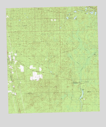
Woodville, FL USGS Topographic Map
Click on map above to begin viewing in our Map Viewer.

This topographic map contains these locations and features:
Feature Name Type Latitude Longitude GNIS ID View Map
Big LakeLakeN30.3697°W84.1293°278703View Map
Bonnet PondLakeN30.3664°W84.1631°279226View Map
Chicken BranchSwampN30.3313°W84.1485°280378View Map
CoreyPopulated PlaceN30.3633°W84.1818°301611View Map
Eagle LakeLakeN30.3620°W84.1553°281920View Map
Hamlin BranchSwampN30.3083°W84.1535°283643View Map
Homer LakeLakeN30.3704°W84.1405°284213View Map
Horn SpringSpringN30.3183°W84.1293°284266View Map
Kelley CemeteryCemeteryN30.3213°W84.1674°283136View Map
Lake ErieLakeN30.3673°W84.1324°282246View Map
Lake MattieLakeN30.3668°W84.1389°286525View Map
Live Oak Orchard PondLakeN30.3607°W84.2313°301610View Map
Lutterloh PondLakeN30.3549°W84.2282°286223View Map
Mary LakeLakeN30.3725°W84.1324°286483View Map
Natural Bridge Battlefield Historic State ParkParkN30.2846°W84.1521°1940025View Map
Natural Bridge SinkBasinN30.2830°W84.1507°287553View Map
Natural Bridge SpringSpringN30.2849°W84.1471°287554View Map
Pump PondLakeN30.3658°W84.1663°289358View Map
Rhodes CemeteryCemeteryN30.3291°W84.2302°1940026View Map
Rhodes CemeteryCemeteryN30.3413°W84.2474°1940027View Map
Rhodes SpringsSpringN30.2810°W84.1507°289651View Map
RosePopulated PlaceN30.3494°W84.1335°295586View Map
Saint Marks SpringSpringN30.2763°W84.1485°1940028View Map
Saint Phillip Primitive Baptist Church of ChristChurchN30.3724°W84.1707°300612View Map
Southeast Leon DivisionCivilN30.3420°W84.1821°1935930View Map
Tallahassee Southeast Division (historical)CensusN30.3452°W84.1830°1935949View Map
Turf PondLakeN30.3619°W84.1660°292503View Map
Twin LakesLakeN30.3735°W84.1350°292614View Map
VereenPopulated PlaceN30.2730°W84.2410°295686View Map
Wakulla Correctional InstitutionBuildingN30.2612°W84.1764°2753077View Map
Wakulla Correctional Institution AnnexBuildingN30.2633°W84.1753°2753076View Map
WoodvillePopulated PlaceN30.3141°W84.2474°306616View Map
Woodville Elementary SchoolSchoolN30.3141°W84.2468°298424View Map
Woodville Post OfficePost OfficeN30.3258°W84.2495°2765671View Map
WTWF-AM (Woodville)TowerN30.2894°W84.2366°310153View Map

Note: Coordinates in the location and feature list above are referenced to NAD83 datum.


Copyright (C) 2008-2025 Ryan Niemi / Sunset Dynamics ... All Rights Reserved