TopoQuest Logo
Do you find TopoQuest useful?
Help keep TopoQuest running and adding new maps/features by donating!
Bitcoin:  19c7KJd3qBynnjoSw5npx9KScwjBe4ifkT
Litecoin:  LXs6TkuXGGXo1vDsWCkWVdjQX94eUKd6ui
Home View Maps Find Maps Find Places Resources & Links


Lloyd, Florida Topographic Map

USGS Map Title: Lloyd, FL
USGS Map MRC: 30084D1
DRG (GeoTIFF) Download: o30084d1.tif


Neighboring USGS Topographic Map Quads:


  Bradfordville, FL  
30084E2
 

  Miccosukee, FL  
30084E1
 

  Lake Miccosukee, FL  
30083E8
 

  Lafayette, FL  
30084D2
 

  Lloyd, FL  
30084D1
 

  Waukeenah, FL  
30083D8
 

  Woodville, FL  
30084C2
 

  Cody, FL  
30084C1
 

  Wacissa, FL  
30083C8


Map MRC Location:

N31°
W85°
N31°
W84°
H8 H7 H6 H5 H4 H3 H2 H1
G8 G7 G6 G5 G4 G3 G2 G1
F8 F7 F6 F5 F4 F3 F2 F1
E8 E7 E6 E5 E4 E3 E2 E1
D8 D7 D6 D5 D4 D3 D2 D1
C8 C7 C6 C5 C4 C3 C2 C1
B8 B7 B6 B5 B4 B3 B2 B1
A8 A7 A6 A5 A4 A3 A2 A1
N30°
W85°
N30°
W84°

Lloyd, FL USGS 1:24K Topographic Map Preview:
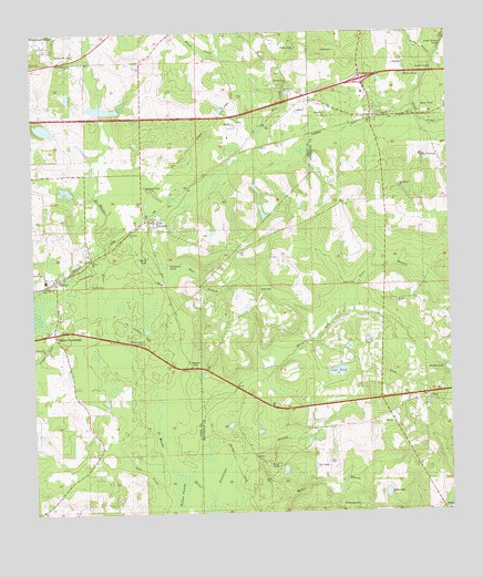
Lloyd, FL USGS Topographic Map
Click on map above to begin viewing in our Map Viewer.

This topographic map contains these locations and features:
Feature Name Type Latitude Longitude GNIS ID View Map
Alfred BranchStreamN30.4930°W84.0038°277743View Map
Angel's FieldAirportN30.4831°W84.0873°2676716View Map
Barrow Hill CemeteryCemeteryN30.4952°W84.1166°278130View Map
Bird SinkBasinN30.4866°W84.0471°278843View Map
Black CreekStreamN30.4730°W84.0560°278889View Map
Brice PondLakeN30.4805°W84.0078°279373View Map
Broomsage CemeteryCemeteryN30.3766°W84.0263°279452View Map
Burnt Mill CreekStreamN30.4041°W84.0704°279713View Map
CapitolaPopulated PlaceN30.4510°W84.0879°280012View Map
ChairesPopulated PlaceN30.4363°W84.1174°280278View Map
Chaires Elementary SchoolSchoolN30.4358°W84.1207°298418View Map
Charlotte's FieldAirportN30.4774°W84.0338°309911View Map
Chires Capitola Volunteer Fire Department and Emergency Medical ServicesBuildingN30.4715°W84.0962°2644469View Map
Copeland SinkBasinN30.4596°W84.0891°280791View Map
Creek SinkBasinN30.4896°W84.0041°281024View Map
Crow PondLakeN30.4117°W84.0336°281105View Map
Elizabeth ChurchChurchN30.4780°W84.0357°282157View Map
First Baptist Church of LloydChurchN30.4798°W84.0197°2450565View Map
Galilee ChurchChurchN30.4419°W84.1060°282880View Map
Gray SinkBasinN30.3877°W84.0516°283355View Map
Hall BranchStreamN30.4424°W84.0899°283618View Map
Jefferson County Fire District Lloyd Volunteer Fire DepartmentBuildingN30.4779°W84.0212°2644121View Map
Jones CemeteryCemeteryN30.4335°W84.0560°284905View Map
Lake DrainStreamN30.4955°W84.0007°285233View Map
Lake Drain SinkBasinN30.4955°W84.0010°285234View Map
LloydPopulated PlaceN30.4774°W84.0218°285896View Map
Lloyd Census Designated PlaceCensusN30.4822°W84.0244°2628526View Map
Lloyd CreekStreamN30.4958°W84.0010°285897View Map
Lloyd Post OfficePost OfficeN30.4777°W84.0217°2783461View Map
Lott CemeteryCemeteryN30.3885°W84.0357°286125View Map
Ox LakeLakeN30.3872°W84.0408°288322View Map
Patty SinkBasinN30.4955°W84.0443°288581View Map
Pine Grove ChurchChurchN30.4183°W84.1210°288845View Map
Polar BranchStreamN30.4263°W84.0285°289138View Map
Saint Lukes ChurchChurchN30.4846°W84.0504°290275View Map
Saint Peters ChurchChurchN30.4566°W84.1077°290372View Map
Saint Rilla Missionary Baptist ChurchChurchN30.4303°W84.0157°2450833View Map
Skipper CemeteryCemeteryN30.4205°W84.0916°291206View Map
Springfield ChurchChurchN30.4588°W84.0129°291572View Map
Still CreekStreamN30.4866°W84.0468°291701View Map
Story LakeLakeN30.3802°W84.0193°291735View Map
Sweetwater BranchStreamN30.3799°W84.0713°291945View Map
The CascadeBasinN30.4669°W84.0071°292152View Map
Union Branch ChurchChurchN30.4924°W84.1127°292648View Map
Upchurch PondLakeN30.4395°W84.0842°292699View Map
WGLF-FM (Tallahassee)TowerN30.4527°W84.0138°310262View Map
Willie CemeteryCemeteryN30.4949°W84.0329°293345View Map
Willie PondLakeN30.4889°W84.0077°293346View Map
Wood SinkBasinN30.4424°W84.0899°293492View Map

Note: Coordinates in the location and feature list above are referenced to NAD83 datum.


Copyright (C) 2008-2024 Ryan Niemi / Sunset Dynamics ... All Rights Reserved