TopoQuest Logo
Do you find TopoQuest useful?
Help keep TopoQuest running and adding new maps/features by donating!
Bitcoin:  19c7KJd3qBynnjoSw5npx9KScwjBe4ifkT
Litecoin:  LXs6TkuXGGXo1vDsWCkWVdjQX94eUKd6ui
Home View Maps Find Maps Find Places Resources & Links


Lafayette, Florida Topographic Map

USGS Map Title: Lafayette, FL
USGS Map MRC: 30084D2
DRG (GeoTIFF) Download: o30084d2.tif


Neighboring USGS Topographic Map Quads:


  Lake Jackson, FL  
30084E3
 

  Bradfordville, FL  
30084E2
 

  Miccosukee, FL  
30084E1
 

  Tallahassee, FL  
30084D3
 

  Lafayette, FL  
30084D2
 

  Lloyd, FL  
30084D1
 

  Lake Munson, FL  
30084C3
 

  Woodville, FL  
30084C2
 

  Cody, FL  
30084C1


Map MRC Location:

N31°
W85°
N31°
W84°
H8 H7 H6 H5 H4 H3 H2 H1
G8 G7 G6 G5 G4 G3 G2 G1
F8 F7 F6 F5 F4 F3 F2 F1
E8 E7 E6 E5 E4 E3 E2 E1
D8 D7 D6 D5 D4 D3 D2 D1
C8 C7 C6 C5 C4 C3 C2 C1
B8 B7 B6 B5 B4 B3 B2 B1
A8 A7 A6 A5 A4 A3 A2 A1
N30°
W85°
N30°
W84°

Lafayette, FL USGS 1:24K Topographic Map Preview:
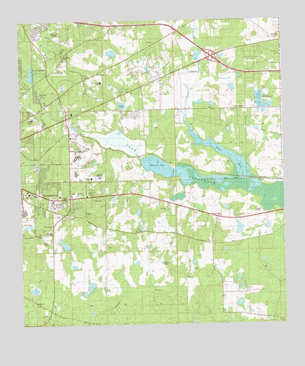
Lafayette, FL USGS Topographic Map
Click on map above to begin viewing in our Map Viewer.

This topographic map contains these locations and features:
Feature Name Type Latitude Longitude GNIS ID View Map
A J Henry ParkParkN30.4991°W84.2146°2005941View Map
Alford ArmLakeN30.4425°W84.1495°277742View Map
Apalachee Elementary SchoolSchoolN30.4357°W84.2160°298420View Map
Awakening ChapelChurchN30.4280°W84.2416°300606View Map
Blairstone PlazaLocaleN30.4288°W84.2430°295874View Map
Buck LakeLakeN30.4652°W84.2013°279579View Map
Calvary ChurchChurchN30.4583°W84.2257°2005939View Map
Capital CenterLocaleN30.4555°W84.2427°295875View Map
Capital Heights ChurchChurchN30.4196°W84.1549°2006955View Map
Capital Regional Medical CenterHospitalN30.4757°W84.2319°298694View Map
Catholic Church of Blessed SacramentChurchN30.4599°W84.2457°300586View Map
Centerville Post OfficePost OfficeN30.4763°W84.2386°2783369View Map
Chaires Capitola Community ParkParkN30.4405°W84.1332°2006952View Map
East Spring ChurchChurchN30.4638°W84.1435°282034View Map
Edwards HospitalHospitalN30.4602°W84.2443°282110View Map
Faith Baptist ChurchChurchN30.4308°W84.2416°300599View Map
Florida Highway Patrol General HeadquartersBuildingN30.4280°W84.2316°2754472View Map
Florida Highway Patrol Troop HBuildingN30.4546°W84.2455°2754488View Map
Free Will ChurchChurchN30.4130°W84.1821°282801View Map
GardnerPopulated PlaceN30.4916°W84.1255°295311View Map
Golden Window SchoolSchoolN30.4680°W84.2143°301503View Map
Govenors ParkParkN30.4402°W84.2452°2005938View Map
Grace Lutheran ChurchChurchN30.4683°W84.2291°300603View Map
Greek Orthodox Church Holy Mother of GodChurchN30.4585°W84.2388°300585View Map
HealthSouth Rehabilitation Hospital of TallahasseeHospitalN30.4594°W84.2371°2094934View Map
Hogan PondLakeN30.3987°W84.1861°284115View Map
J C Headley PondLakeN30.4147°W84.1464°298242View Map
J R Alford GreenwayParkN30.4460°W84.1666°2006951View Map
J R Alford PondLakeN30.4563°W84.1693°298243View Map
L Kirk Edwards State Wildlife and Environment AreaParkN30.4321°W84.1463°2006954View Map
LafayettePopulated PlaceN30.4280°W84.2163°285205View Map
Lafayette Presbyterian ChurchChurchN30.4280°W84.2138°300610View Map
Lake Ellen Baptist ChurchChurchN30.4030°W84.2346°300590View Map
Lake LafayetteLakeN30.4356°W84.1672°285255View Map
Lake Lafayette Heritage Trail ParkParkN30.4369°W84.1713°2006953View Map
Learning Tree Child CareSchoolN30.4788°W84.2368°301505View Map
Leon County Emergency Medical ServicesBuildingN30.4507°W84.2217°2754541View Map
Leon County Emergency Medical ServicesBuildingN30.4641°W84.2447°2661717View Map
Lifenet TallahasseeBuildingN30.4753°W84.2306°2661882View Map
Lincoln High SchoolSchoolN30.4356°W84.2126°298419View Map
Lower Lake LafayetteLakeN30.4331°W84.1467°2770762View Map
Montessori Cooperative Early SchoolSchoolN30.4705°W84.1999°301504View Map
Moore SchoolSchoolN30.4752°W84.2124°2005940View Map
Morningside Baptist ChapelChurchN30.4683°W84.1832°300589View Map
Mount Bethlehem Primitive Baptist ChurchChurchN30.4155°W84.2346°300609View Map
Mount Olive ChurchChurchN30.4774°W84.2171°287269View Map
Mount Pisgah ChurchChurchN30.3841°W84.2435°287292View Map
Mount Sinai ChurchChurchN30.4224°W84.1807°287316View Map
New Zion ChurchChurchN30.4785°W84.2130°287704View Map
Pedrick PondReservoirN30.4751°W84.1808°2765059View Map
PerkinsPopulated PlaceN30.4541°W84.2224°295532View Map
Piney Z LakeReservoirN30.4404°W84.1851°288970View Map
Queen ChapelChurchN30.4246°W84.2441°289399View Map
Register JunctionLocaleN30.4591°W84.2263°301606View Map
Saint PeterPopulated PlaceN30.4858°W84.2291°290369View Map
Shady Grove ChurchChurchN30.4849°W84.1257°290903View Map
Shepherd BranchStreamN30.3805°W84.2157°291004View Map
Soda Field CemeteryCemeteryN30.4129°W84.2353°291319View Map
Spring Hill ChurchChurchN30.4196°W84.2277°2005936View Map
Tallahassee CenterLocaleN30.4321°W84.2457°295871View Map
Tallahassee City Fire Department Station 12BuildingN30.4387°W84.1254°2644270View Map
Tallahassee City Fire Department Station 6BuildingN30.4263°W84.2305°2644335View Map
Tallahassee East DivisionCivilN30.4448°W84.2427°1935945View Map
Tallahassee Heights ChurchChurchN30.4610°W84.2268°291997View Map
Tallahassee National CemeteryCemeteryN30.4209°W84.1873°2775474View Map
Testreana ChurchChurchN30.4916°W84.1852°292142View Map
Tom Brown ParkParkN30.4460°W84.2152°2005937View Map
Town East Christian SchoolSchoolN30.4210°W84.2313°301502View Map
Upper Lake LafayetteLakeN30.4494°W84.2006°2770761View Map
Walter T Moore Junior Elementary SchoolSchoolN30.4746°W84.2110°298421View Map
WANM-AM (Tallahassee)TowerN30.4274°W84.2452°308908View Map
Ward SchoolSchoolN30.4196°W84.2274°292877View Map
WGLF-FM (Tallahassee)TowerN30.4274°W84.2452°309140View Map
WUMX-FM (Tallahassee)TowerN30.4955°W84.2307°309142View Map

Note: Coordinates in the location and feature list above are referenced to NAD83 datum.


Copyright (C) 2008-2024 Ryan Niemi / Sunset Dynamics ... All Rights Reserved