TopoQuest Logo
Do you find TopoQuest useful?
Help keep TopoQuest running and adding new maps/features by donating!
Bitcoin:  19c7KJd3qBynnjoSw5npx9KScwjBe4ifkT
Litecoin:  LXs6TkuXGGXo1vDsWCkWVdjQX94eUKd6ui
Home View Maps Find Maps Find Places Resources & Links


Wyocena, Wisconsin Topographic Map

USGS Map Title: Wyocena, WI
USGS Map MRC: 43089D3
DRG (GeoTIFF) Download: o43089d3.tif


Neighboring USGS Topographic Map Quads:


  Portage, WI  
43089E4
 

  Pardeeville, WI  
43089E3
 

  Sand Spring Creek, WI  
43089E2
 

  Poynette, WI  
43089D4
 

  Wyocena, WI  
43089D3
 

  Rio, WI  
43089D2
 

  Arlington, WI  
43089C4
 

  Morrisonville, WI  
43089C3
 

  North Bristol, WI  
43089C2


Map MRC Location:

N44°
W90°
N44°
W89°
H8 H7 H6 H5 H4 H3 H2 H1
G8 G7 G6 G5 G4 G3 G2 G1
F8 F7 F6 F5 F4 F3 F2 F1
E8 E7 E6 E5 E4 E3 E2 E1
D8 D7 D6 D5 D4 D3 D2 D1
C8 C7 C6 C5 C4 C3 C2 C1
B8 B7 B6 B5 B4 B3 B2 B1
A8 A7 A6 A5 A4 A3 A2 A1
N43°
W90°
N43°
W89°

Wyocena, WI USGS 1:24K Topographic Map Preview:
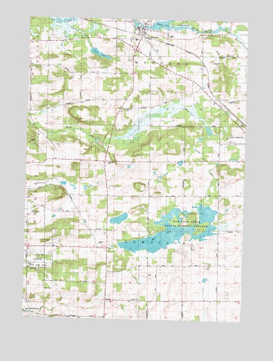
Wyocena, WI USGS Topographic Map
Click on map above to begin viewing in our Map Viewer.

This topographic map contains these locations and features:
Feature Name Type Latitude Longitude GNIS ID View Map
1.37 ReservoirReservoirN43.4883°W89.3401°1792478View Map
37 ReservoirReservoirN43.4950°W89.2701°1792131View Map
Columbia CountyCivilN43.4666°W89.3337°1581070View Map
Curtis 2WP1601 DamDamN43.4883°W89.3401°1792477View Map
Curtis CreekStreamN43.4980°W89.3554°1842947View Map
Curtis LakeReservoirN43.4854°W89.3349°1842948View Map
Curtis Landing Strip (historical)AirportN43.4205°W89.3715°1842949View Map
Figor DamDamN43.4950°W89.2701°1792130View Map
Gilbert FieldAirportN43.4516°W89.2530°1582182View Map
Knutson FieldAirportN43.4821°W89.3196°2444176View Map
Little Bluff CampgroundLocaleN43.4208°W89.3072°2515655View Map
LowvillePopulated PlaceN43.3825°W89.3271°1577710View Map
Lowville CemeteryCemeteryN43.3833°W89.3134°1568771View Map
Lowville Center SchoolSchoolN43.4119°W89.3337°1568772View Map
Middle Branch Duck CreekStreamN43.4980°W89.2957°1569410View Map
Mill House FieldAirportN43.4951°W89.2666°2444175View Map
Mud LakeLakeN43.4118°W89.2906°1569912View Map
Mud Lake State Public Hunting GroundsParkN43.4139°W89.2854°1842989View Map
North Branch Duck CreekStreamN43.4983°W89.2957°1570371View Map
Poynette State Game FarmLocaleN43.3975°W89.3715°1843009View Map
Prescott FieldAirportN43.4836°W89.2948°1582282View Map
Rocky Run Catholic CemeteryCemeteryN43.4625°W89.3193°1572519View Map
Rocky Run Oak Savanna State Natural AreaParkN43.4567°W89.3426°2055083View Map
Rocky Run Protestant CemeteryCemeteryN43.4408°W89.3287°1572518View Map
South Lowville SchoolSchoolN43.3786°W89.3293°1574467View Map
Taff D2076 DamDamN43.4567°W89.2718°1792788View Map
Town of LowvilleCivilN43.4120°W89.3041°1583602View Map
Village of WyocenaCivilN43.4931°W89.3099°1584488View Map
Weatherbee FieldAirportN43.4692°W89.3595°2444177View Map
WyocenaPopulated PlaceN43.4958°W89.3085°1577066View Map
Wyocena Bureau of FireBuildingN43.4945°W89.3105°2698004View Map
Wyocena DamDamN43.4994°W89.3162°1792132View Map
Wyocena Police DepartmentBuildingN43.4943°W89.3091°2759981View Map
Wyocena Post OfficePost OfficeN43.4947°W89.3092°2723977View Map
Wyona County ParkParkN43.4978°W89.2929°1843057View Map
Wyona LakeReservoirN43.4978°W89.3010°1792133View Map

Note: Coordinates in the location and feature list above are referenced to NAD83 datum.


Copyright (C) 2008-2025 Ryan Niemi / Sunset Dynamics ... All Rights Reserved