TopoQuest Logo
Do you find TopoQuest useful?
Help keep TopoQuest running and adding new maps/features by donating!
Bitcoin:  19c7KJd3qBynnjoSw5npx9KScwjBe4ifkT
Litecoin:  LXs6TkuXGGXo1vDsWCkWVdjQX94eUKd6ui
Home View Maps Find Maps Find Places Resources & Links


Yager Junction, California Topographic Map

USGS Map Title: Yager Junction, CA
USGS Map MRC: 40123E7
DRG (GeoTIFF) Download: o40123e7.tif


Neighboring USGS Topographic Map Quads:


  Iaqua Buttes, CA  
40123F8
 

  Mad River Buttes, CA  
40123F7
 

  Board Camp Mountain, CA  
40123F6
 

  Owl Creek, CA  
40123E8
 

  Yager Junction, CA  
40123E7
 

  Showers Mountain, CA  
40123E6
 

  Redcrest, CA  
40123D8
 

  Bridgeville, CA  
40123D7
 

  Larabee Valley, CA  
40123D6


Map MRC Location:

N41°
W124°
N41°
W123°
H8 H7 H6 H5 H4 H3 H2 H1
G8 G7 G6 G5 G4 G3 G2 G1
F8 F7 F6 F5 F4 F3 F2 F1
E8 E7 E6 E5 E4 E3 E2 E1
D8 D7 D6 D5 D4 D3 D2 D1
C8 C7 C6 C5 C4 C3 C2 C1
B8 B7 B6 B5 B4 B3 B2 B1
A8 A7 A6 A5 A4 A3 A2 A1
N40°
W124°
N40°
W123°

Yager Junction, CA USGS 1:24K Topographic Map Preview:
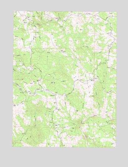
Yager Junction, CA USGS Topographic Map
Click on map above to begin viewing in our Map Viewer.

This topographic map contains these locations and features:
Feature Name Type Latitude Longitude GNIS ID View Map
Bloody RunStreamN40.5288°W123.7684°233517View Map
Bone FlatFlatN40.5651°W123.8000°233533View Map
Butte CreekStreamN40.6149°W123.8237°233587View Map
Cashlapooda CreekStreamN40.5265°W123.7864°233642View Map
Chimney RockPillarN40.5326°W123.7639°233666View Map
Coyote CreekStreamN40.5235°W123.7920°233732View Map
Coyote ValleyValleyN40.5732°W123.7645°233734View Map
Dairy CreekStreamN40.6124°W123.8464°233750View Map
Dairy RidgeRidgeN40.5879°W123.8187°233751View Map
Danger CreekStreamN40.5290°W123.7709°233755View Map
Donkey PointCapeN40.5171°W123.8034°233792View Map
Ellison CreekStreamN40.6146°W123.8364°233848View Map
Fern RidgeRidgeN40.5765°W123.8662°233871View Map
Fort Baker RanchLocaleN40.5874°W123.8159°233890View Map
Freese CreekStreamN40.6018°W123.7953°233902View Map
Hansen HillSummitN40.5604°W123.8153°233981View Map
Hansen QuarryMineN40.5344°W123.8281°2677845View Map
Hansom CorralsLocaleN40.5624°W123.7789°233983View Map
Harts ValleyValleyN40.6062°W123.7659°233990View Map
Humsted RidgeRidgeN40.5565°W123.8587°234056View Map
Iaqua CreekStreamN40.6146°W123.8642°234062View Map
Iaqua RanchLocaleN40.6193°W123.8587°234063View Map
Indian CreekStreamN40.6018°W123.7953°234065View Map
Little Butte CreekStreamN40.6207°W123.8420°234167View Map
McAlvey RidgeRidgeN40.6224°W123.7878°234257View Map
Olsen CreekStreamN40.5865°W123.7803°255117View Map
Palace RockPillarN40.5335°W123.7987°234426View Map
Palace Rock RanchLocaleN40.5340°W123.8214°234427View Map
Pigeon RockPillarN40.5607°W123.8448°234462View Map
Porter Ranch (historical)LocaleN40.5782°W123.7670°1665264View Map
Red HillSummitN40.5507°W123.7581°1659787View Map
Salmon CreekStreamN40.6154°W123.8731°234608View Map
Scott CreekStreamN40.5160°W123.7934°234661View Map
Showers Pass School (historical)SchoolN40.6040°W123.7564°1665282View Map
Sunny Basin RanchLocaleN40.5201°W123.8212°235784View Map
Yager JunctionPopulated PlaceN40.5482°W123.8245°252840View Map
Yager ValleyValleyN40.5493°W123.8634°238221View Map

Note: Coordinates in the location and feature list above are referenced to NAD83 datum.


Copyright (C) 2008-2025 Ryan Niemi / Sunset Dynamics ... All Rights Reserved