TopoQuest Logo
Do you find TopoQuest useful?
Help keep TopoQuest running and adding new maps/features by donating!
Bitcoin:  19c7KJd3qBynnjoSw5npx9KScwjBe4ifkT
Litecoin:  LXs6TkuXGGXo1vDsWCkWVdjQX94eUKd6ui
Home View Maps Find Maps Find Places Resources & Links


Bourbon, Indiana Topographic Map

USGS Map Title: Bourbon, IN
USGS Map MRC: 41086C1
DRG (GeoTIFF) Download: o41086c1.tif


Neighboring USGS Topographic Map Quads:


  Bremen, IN  
41086D2
 

  Nappanee West, IN  
41086D1
 

  Nappanee East, IN  
41085D8
 

  Inwood, IN  
41086C2
 

  Bourbon, IN  
41086C1
 

  Atwood, IN  
41085C8
 

  Argos, IN  
41086B2
 

  Mentone, IN  
41086B1
 

  Burket, IN  
41085B8


Map MRC Location:

N42°
W87°
N42°
W86°
H8 H7 H6 H5 H4 H3 H2 H1
G8 G7 G6 G5 G4 G3 G2 G1
F8 F7 F6 F5 F4 F3 F2 F1
E8 E7 E6 E5 E4 E3 E2 E1
D8 D7 D6 D5 D4 D3 D2 D1
C8 C7 C6 C5 C4 C3 C2 C1
B8 B7 B6 B5 B4 B3 B2 B1
A8 A7 A6 A5 A4 A3 A2 A1
N41°
W87°
N41°
W86°

Bourbon, IN USGS 1:24K Topographic Map Preview:
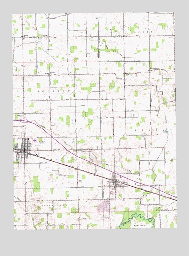
Bourbon, IN USGS Topographic Map
Click on map above to begin viewing in our Map Viewer.

This topographic map contains these locations and features:
Feature Name Type Latitude Longitude GNIS ID View Map
Arm Number Two DitchCanalN41.2814°W86.0164°430252View Map
Arrowhead Farm AirportAirportN41.2921°W86.0738°2677087View Map
Baker DitchCanalN41.2673°W86.1203°430432View Map
BourbonPopulated PlaceN41.2956°W86.1164°431382View Map
Bourbon Emergency Medical ServiceBuildingN41.2969°W86.1160°2701433View Map
Bourbon Post OfficePost OfficeN41.2969°W86.1167°2710752View Map
Bourbon Public LibraryBuildingN41.2978°W86.1167°2709039View Map
Bourbon Town Police DepartmentBuildingN41.2969°W86.1161°2758145View Map
Bourbon Town Volunteer Fire DepartmentBuildingN41.2970°W86.1161°2625566View Map
Brock DitchCanalN41.3578°W86.1119°431554View Map
Camp Creek ChurchChurchN41.3398°W86.0381°432025View Map
Danner DitchCanalN41.3167°W86.0383°433312View Map
Erwin DitchCanalN41.2934°W86.0847°434237View Map
Etna GreenPopulated PlaceN41.2789°W86.0461°452111View Map
Etna Township Fire DepartmentBuildingN41.2768°W86.0481°2626232View Map
Fairview ChurchChurchN41.3614°W86.1167°434345View Map
Foster ChapelChurchN41.3609°W86.1019°434702View Map
Hanes FarmsLocaleN41.3378°W86.0794°2709047View Map
J and M Gravel PitMineN41.2639°W86.0553°2649519View Map
Jerusalem ChurchChurchN41.3398°W86.0964°436999View Map
Kinzie DitchCanalN41.3470°W86.1231°437349View Map
Knepp FarmsLocaleN41.3256°W86.1050°2709043View Map
Lemer-Berger DitchCanalN41.3050°W86.0931°437767View Map
Lemlar FarmsLocaleN41.3453°W86.0578°2709048View Map
Lemler DitchCanalN41.3625°W86.0675°437770View Map
Martin DitchCanalN41.3209°W86.0186°438672View Map
Miller FarmsLocaleN41.3600°W86.0753°2709044View Map
Millwood ChapelChurchN41.3414°W86.0192°439251View Map
Mud LakeLakeN41.3058°W86.0073°439829View Map
Parks Memorial CemeteryCemeteryN41.2893°W86.1191°440509View Map
Parks Memorial CemeteryCemeteryN41.2898°W86.1197°440893View Map
Ridenour DitchCanalN41.2917°W86.0614°441987View Map
Robinson DitchCanalN41.2637°W86.0086°442179View Map
Rust's LandingAirportN41.3627°W86.0630°2677080View Map
Saint Pauls ChurchChurchN41.3392°W86.0972°442786View Map
Sandridge CemeteryCemeteryN41.3623°W86.1022°443003View Map
Sechrist DitchCanalN41.3509°W86.0411°443188View Map
Town of BourbonCivilN41.2976°W86.1174°2396599View Map
Town of Etna GreenCivilN41.2756°W86.0460°2396930View Map
Township of EtnaCivilN41.2974°W86.0285°453280View Map

Note: Coordinates in the location and feature list above are referenced to NAD83 datum.


Copyright (C) 2008-2024 Ryan Niemi / Sunset Dynamics ... All Rights Reserved