TopoQuest Logo
Do you find TopoQuest useful?
Help keep TopoQuest running and adding new maps/features by donating!
Bitcoin:  19c7KJd3qBynnjoSw5npx9KScwjBe4ifkT
Litecoin:  LXs6TkuXGGXo1vDsWCkWVdjQX94eUKd6ui
Home View Maps Find Maps Find Places Resources & Links


Alexander Springs, Florida Topographic Map

USGS Map Title: Alexander Springs, FL
USGS Map MRC: 29081A5
DRG (GeoTIFF) Download: o29081a5.tif


Neighboring USGS Topographic Map Quads:


  Juniper Springs, FL  
29081B6
 

  Astor, FL  
29081B5
 

  Pierson, FL  
29081B4
 

  Farles Lake, FL  
29081A6
 

  Alexander Springs, FL  
29081A5
 

  Lake Woodruff, FL  
29081A4
 

  Umatilla, FL  
28081H6
 

  Paisley, FL  
28081H5
 

  Pine Lakes, FL  
28081H4


Map MRC Location:

N30°
W82°
N30°
W81°
H8 H7 H6 H5 H4 H3 H2 H1
G8 G7 G6 G5 G4 G3 G2 G1
F8 F7 F6 F5 F4 F3 F2 F1
E8 E7 E6 E5 E4 E3 E2 E1
D8 D7 D6 D5 D4 D3 D2 D1
C8 C7 C6 C5 C4 C3 C2 C1
B8 B7 B6 B5 B4 B3 B2 B1
A8 A7 A6 A5 A4 A3 A2 A1
N29°
W82°
N29°
W81°

Alexander Springs, FL USGS 1:24K Topographic Map Preview:
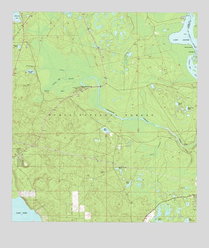
Alexander Springs, FL USGS Topographic Map
Click on map above to begin viewing in our Map Viewer.

This topographic map contains these locations and features:
Feature Name Type Latitude Longitude GNIS ID View Map
Alco DockLocaleN29.1225°W81.5081°306932View Map
Alexander SpringsPopulated PlaceN29.0803°W81.5781°305200View Map
Alexander Springs Recreation AreaParkN29.0791°W81.5798°306931View Map
Astor Landing MarinaHarborN29.1210°W81.5078°2447605View Map
Billies BayBayN29.0783°W81.5940°305310View Map
Billies Bay WildernessReserveN29.0918°W81.5906°307064View Map
Billies BranchStreamN29.0850°W81.5776°305311View Map
Blue LakeLakeN29.0010°W81.5064°305340View Map
Bobcat PondLakeN29.0708°W81.5135°305351View Map
Bowers BluffCliffN29.1053°W81.5034°305363View Map
Bunch Ground PondLakeN29.0323°W81.5539°305414View Map
Dillard PondLakeN29.1044°W81.6205°305579View Map
Duck PondLakeN29.0228°W81.5456°305603View Map
Eagle Nest PondLakeN29.0682°W81.5066°305609View Map
F J Advice GrantCivilN29.1050°W81.5284°306846View Map
Flatwoods TrailTrailN29.0586°W81.6237°307033View Map
Francis Marin GrantCivilN29.0961°W81.5126°306847View Map
Glenn BranchStreamN29.0572°W81.5248°305728View Map
Idlewilde PointCapeN29.1022°W81.5009°305851View Map
Lake DorrLakeN29.0014°W81.6221°305590View Map
Lakeview ParkParkN29.0108°W81.5065°307067View Map
Moses E Levy GrantCivilN29.0672°W81.5253°306879View Map
Mud PondLakeN29.0550°W81.5613°306086View Map
Ninemile CreekStreamN29.0864°W81.5723°306112View Map
Powells Campground Mobile Home ParkPopulated PlaceN29.1198°W81.5120°2447610View Map
Sand Hill PondLakeN29.0896°W81.6126°306349View Map
Scrub Jay PondLakeN29.0112°W81.5058°2054455View Map
Sellers Lake Boat RampLocaleN29.1236°W81.6201°307052View Map
Shockley CemeteryCemeteryN29.0300°W81.5642°306384View Map
Stagger Mud LakeLakeN29.0916°W81.5019°306444View Map
Tracy CanalCanalN29.0253°W81.5001°306509View Map

Note: Coordinates in the location and feature list above are referenced to NAD83 datum.


Copyright (C) 2008-2024 Ryan Niemi / Sunset Dynamics ... All Rights Reserved