TopoQuest Logo
Do you find TopoQuest useful?
Help keep TopoQuest running and adding new maps/features by donating!
Bitcoin:  19c7KJd3qBynnjoSw5npx9KScwjBe4ifkT
Litecoin:  LXs6TkuXGGXo1vDsWCkWVdjQX94eUKd6ui
Home View Maps Find Maps Find Places Resources & Links


Boylers Mill, Missouri Topographic Map

USGS Map Title: Boylers Mill, MO
USGS Map MRC: 38093C1
DRG (GeoTIFF) Download: o38093c1.tif


Neighboring USGS Topographic Map Quads:


  Cole Camp, MO  
38093D2
 

  Crockerville, MO  
38093D1
 

  Stover, MO  
38092D8
 

  Lakeview Heights, MO  
38093C2
 

  Boylers Mill, MO  
38093C1
 

  Proctor Creek, MO  
38092C8
 

  Edwards, MO  
38093B2
 

  Knobby, MO  
38093B1
 

  Bollinger Creek, MO  
38092B8


Map MRC Location:

N39°
W94°
N39°
W93°
H8 H7 H6 H5 H4 H3 H2 H1
G8 G7 G6 G5 G4 G3 G2 G1
F8 F7 F6 F5 F4 F3 F2 F1
E8 E7 E6 E5 E4 E3 E2 E1
D8 D7 D6 D5 D4 D3 D2 D1
C8 C7 C6 C5 C4 C3 C2 C1
B8 B7 B6 B5 B4 B3 B2 B1
A8 A7 A6 A5 A4 A3 A2 A1
N38°
W94°
N38°
W93°

Boylers Mill, MO USGS 1:24K Topographic Map Preview:
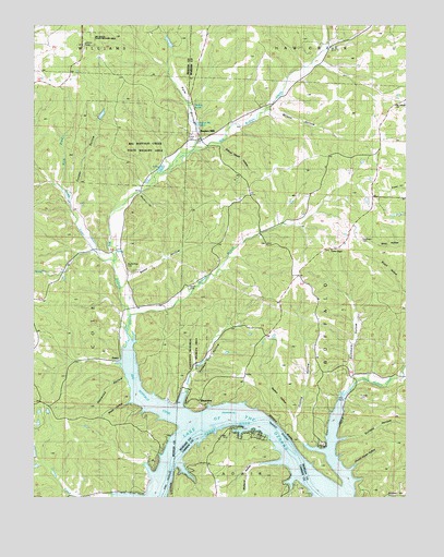
Boylers Mill, MO USGS Topographic Map
Click on map above to begin viewing in our Map Viewer.

This topographic map contains these locations and features:
Feature Name Type Latitude Longitude GNIS ID View Map
Archer CreekStreamN38.3125°W93.0985°713373View Map
Attners BluffsCliffN38.2692°W93.0424°713476View Map
Bates HollowValleyN38.3053°W93.0966°738328View Map
Big Bend AcresPopulated PlaceN38.2661°W93.0624°739164View Map
Big Buffalo CemeteryCemeteryN38.3117°W93.0941°742759View Map
Big Buffalo CoveBayN38.2772°W93.0902°714145View Map
Big Buffalo CreekStreamN38.2772°W93.0902°729705View Map
Big Buffalo Creek State Wildlife AreaParkN38.3428°W93.0877°742760View Map
Big Buffalo SchoolSchoolN38.3134°W93.0949°714146View Map
Big Buffaloe School (historical)SchoolN38.3136°W93.0946°745386View Map
Bockelman Lake DamDamN38.3700°W93.0802°765299View Map
Boylers MillPopulated PlaceN38.3472°W93.0708°729710View Map
Boylers Mill (historical)LocaleN38.3403°W93.0799°746464View Map
Boylers Mill SpringSpringN38.3492°W93.0702°738320View Map
Carpenter Memorial State Wildlife AreaParkN38.2875°W93.0716°742757View Map
Central OzarksAreaN38.2503°W93.0752°754113View Map
Church House HollowValleyN38.2572°W93.0188°715846View Map
Cooper HollowValleyN38.3275°W93.1130°739167View Map
Cutting HollowValleyN38.2645°W93.0349°738323View Map
Franklin CemeteryCemeteryN38.2767°W93.0157°742756View Map
Frisch CemeteryCemeteryN38.3461°W93.0724°742754View Map
Haywood HollowValleyN38.2820°W93.0946°738327View Map
Hudson SpringSpringN38.3534°W93.0721°738319View Map
Jackson and Keller Trust Lake South DamDamN38.2584°W93.1235°765424View Map
Jackson Keller Trust Lake North DamDamN38.2600°W93.1235°763936View Map
Kreglinger CemeteryCemeteryN38.3184°W93.0152°742755View Map
Little Buffalo ChurchChurchN38.2828°W93.0155°721177View Map
Little Buffalo CreekStreamN38.2528°W93.0199°721178View Map
Mark BranchStreamN38.3322°W93.1160°738330View Map
Mayberry HollowValleyN38.3309°W93.0896°738329View Map
McDavid HollowValleyN38.2597°W93.0416°722088View Map
Minnow BranchStreamN38.2978°W93.0938°729778View Map
Mount Calvary ChurchChurchN38.3536°W93.0035°722722View Map
Mount Hulda Lookout TowerTowerN38.3700°W93.1088°755329View Map
Mount Hulda State Wildfile AreaParkN38.3714°W93.1069°742761View Map
Northwest Fire Protection District Station 3BuildingN38.2644°W93.0636°2620456View Map
Pole HollowValleyN38.3445°W93.0716°724702View Map
Possum Trot HollowValleyN38.2745°W93.0760°724783View Map
Rednar HollowValleyN38.2709°W93.0369°738324View Map
RiverviewPopulated PlaceN38.2759°W93.0696°725351View Map
Riverview School (historical)SchoolN38.2909°W93.0505°745309View Map
Roberts BranchStreamN38.2784°W93.0735°738325View Map
Rock Ridge School (historical)SchoolN38.2511°W93.1063°745387View Map
School House HollowValleyN38.3439°W93.0646°738321View Map
Shiloh CemeteryCemeteryN38.3059°W93.0730°742758View Map
Smith HollowValleyN38.2747°W93.0941°738326View Map
Stover Rural Fire Protection District Station 2BuildingN38.3092°W93.0367°2620634View Map
Sullens HollowValleyN38.2650°W93.0233°727268View Map
Summers HollowValleyN38.2820°W93.0183°727287View Map
Trinity ChapelChurchN38.3156°W93.0260°727783View Map
Wilson HollowValleyN38.3534°W93.0466°738322View Map
ZoraPopulated PlaceN38.2864°W93.0966°729834View Map

Note: Coordinates in the location and feature list above are referenced to NAD83 datum.


Copyright (C) 2008-2025 Ryan Niemi / Sunset Dynamics ... All Rights Reserved