TopoQuest Logo
Do you find TopoQuest useful?
Help keep TopoQuest running and adding new maps/features by donating!
Bitcoin:  19c7KJd3qBynnjoSw5npx9KScwjBe4ifkT
Litecoin:  LXs6TkuXGGXo1vDsWCkWVdjQX94eUKd6ui
Home View Maps Find Maps Find Places Resources & Links


Bollinger Creek, Missouri Topographic Map

USGS Map Title: Bollinger Creek, MO
USGS Map MRC: 38092B8
DRG (GeoTIFF) Download: o38092b8.tif


Neighboring USGS Topographic Map Quads:


  Boylers Mill, MO  
38093C1
 

  Proctor Creek, MO  
38092C8
 

  Gravois Mills, MO  
38092C7
 

  Knobby, MO  
38093B1
 

  Bollinger Creek, MO  
38092B8
 

  Sunrise Beach, MO  
38092B7
 

  Climax Springs, MO  
38093A1
 

  Barnumton, MO  
38092A8
 

  Green Bay Terrace, MO  
38092A7


Map MRC Location:

N39°
W93°
N39°
W92°
H8 H7 H6 H5 H4 H3 H2 H1
G8 G7 G6 G5 G4 G3 G2 G1
F8 F7 F6 F5 F4 F3 F2 F1
E8 E7 E6 E5 E4 E3 E2 E1
D8 D7 D6 D5 D4 D3 D2 D1
C8 C7 C6 C5 C4 C3 C2 C1
B8 B7 B6 B5 B4 B3 B2 B1
A8 A7 A6 A5 A4 A3 A2 A1
N38°
W93°
N38°
W92°

Bollinger Creek, MO USGS 1:24K Topographic Map Preview:
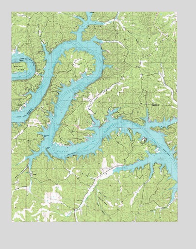
Bollinger Creek, MO USGS Topographic Map
Click on map above to begin viewing in our Map Viewer.

This topographic map contains these locations and features:
Feature Name Type Latitude Longitude GNIS ID View Map
Apache PointCapeN38.1681°W92.9738°738317View Map
Bishop HollowValleyN38.1461°W92.9866°714274View Map
Bollinger CreekStreamN38.1556°W92.9224°714503View Map
Brown BendBendN38.2173°W92.9955°714756View Map
Bunns HollowValleyN38.1423°W92.9341°715056View Map
Camp HornLocaleN38.1720°W92.8816°742748View Map
Carver (historical)LocaleN38.1800°W92.9457°744743View Map
Carver CemeteryCemeteryN38.1759°W92.9394°742749View Map
Chalk HollowValleyN38.1456°W92.9366°715703View Map
Christian Church of the OzarksChurchN38.2256°W92.9796°742751View Map
Clarks School (historical)SchoolN38.1581°W92.9221°745252View Map
Coffman BendBendN38.2181°W92.9538°716071View Map
Coffman Bend Fire Association Station 2BuildingN38.2217°W92.9469°2621595View Map
Coffman Bend Fire Protection Association Station 1 HeadquartersBuildingN38.1778°W92.9933°2621706View Map
Corum (historical)LocaleN38.1817°W92.8988°744746View Map
DoddsPopulated PlaceN38.1542°W92.9852°738318View Map
Duffer HollowValleyN38.2234°W92.9733°717156View Map
Gravois Volunteer Fire DepartmentBuildingN38.1983°W92.9468°2621329View Map
Ivy BendBendN38.2014°W92.9966°720189View Map
Ivy Bend AirportAirportN38.1948°W92.9907°758959View Map
Ivy Bend Fire Department Station 2BuildingN38.2463°W92.9867°2620685View Map
Ivy Bend MissionChurchN38.2153°W92.9813°742750View Map
Jenkins School (historical)SchoolN38.2034°W92.8777°745320View Map
King BluffCliffN38.1640°W92.9554°720604View Map
Little Niangua ArmStreamN38.1797°W92.9004°721282View Map
Little Proctor CreekStreamN38.2431°W92.9335°729768View Map
Mefford HollowValleyN38.1586°W92.9871°722201View Map
Mose Clark CemeteryCemeteryN38.1574°W92.9223°715876View Map
Northwest Fire Protection District Station 2BuildingN38.1450°W92.9410°2620328View Map
Northwest Fire Protection District Station 4BuildingN38.1349°W92.9043°2620455View Map
Osage Iron Works (historical)LocaleN38.1639°W92.9141°744772View Map
Parish CemeteryCemeteryN38.2159°W92.9427°724011View Map
Parmley HollowValleyN38.1439°W92.8769°724050View Map
Pearson BranchStreamN38.1675°W92.9780°729794View Map
Pearson Branch School (historical)SchoolN38.1659°W92.9994°745251View Map
Polly HollowValleyN38.1500°W92.9369°724719View Map
Prairie HollowValleyN38.2009°W92.8752°724864View Map
Shop HollowValleyN38.1586°W92.9146°726408View Map
Sugar Tree HollowValleyN38.1395°W92.9349°727254View Map
Thornsberry PointCapeN38.1745°W92.9763°727617View Map
Township of AdairCivilN38.1410°W92.9520°766388View Map
Wells Branch HollowValleyN38.2425°W92.9330°728499View Map
West Pearson BranchStreamN38.1623°W92.9896°728604View Map
Wildcat HollowValleyN38.1820°W92.9371°729831View Map
Wilson BendBendN38.1820°W92.9549°728955View Map
Wilson Bend School (historical)SchoolN38.1948°W92.9405°745250View Map
Wilson CemeteryCemeteryN38.1714°W92.9569°728961View Map
Woolery CemeteryCemeteryN38.1375°W92.9466°729140View Map

Note: Coordinates in the location and feature list above are referenced to NAD83 datum.


Copyright (C) 2008-2024 Ryan Niemi / Sunset Dynamics ... All Rights Reserved