TopoQuest Logo
Do you find TopoQuest useful?
Help keep TopoQuest running and adding new maps/features by donating!
Bitcoin:  19c7KJd3qBynnjoSw5npx9KScwjBe4ifkT
Litecoin:  LXs6TkuXGGXo1vDsWCkWVdjQX94eUKd6ui
Home View Maps Find Maps Find Places Resources & Links


Breakabeen, New York Topographic Map

USGS Map Title: Breakabeen, NY
USGS Map MRC: 42074E4
DRG (GeoTIFF) Download: o42074e4.tif


Neighboring USGS Topographic Map Quads:


  Richmondville, NY  
42074F5
 

  Cobleskill, NY  
42074F4
 

  Schoharie, NY  
42074F3
 

  Summit, NY  
42074E5
 

  Breakabeen, NY  
42074E4
 

  Middleburgh, NY  
42074E3
 

  Stamford, NY  
42074D5
 

  Gilboa, NY  
42074D4
 

  Livingstonville, NY  
42074D3


Map MRC Location:

N43°
W75°
N43°
W74°
H8 H7 H6 H5 H4 H3 H2 H1
G8 G7 G6 G5 G4 G3 G2 G1
F8 F7 F6 F5 F4 F3 F2 F1
E8 E7 E6 E5 E4 E3 E2 E1
D8 D7 D6 D5 D4 D3 D2 D1
C8 C7 C6 C5 C4 C3 C2 C1
B8 B7 B6 B5 B4 B3 B2 B1
A8 A7 A6 A5 A4 A3 A2 A1
N42°
W75°
N42°
W74°

Breakabeen, NY USGS 1:24K Topographic Map Preview:
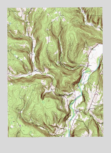
Breakabeen, NY USGS Topographic Map
Click on map above to begin viewing in our Map Viewer.

This topographic map contains these locations and features:
Feature Name Type Latitude Longitude GNIS ID View Map
Barbers FarmLocaleN42.5822°W74.3831°2555044View Map
Bouck HollowValleyN42.5647°W74.3754°944485View Map
Boucks FallsFallsN42.5404°W74.4260°944486View Map
Boucks IslandIslandN42.5570°W74.3976°944487View Map
BreakabeenPopulated PlaceN42.5242°W74.4096°944669View Map
Breakabeen CemeteryCemeteryN42.5248°W74.3988°2554542View Map
Cole BrookStreamN42.5026°W74.4251°977496View Map
Cole HollowValleyN42.5028°W74.4257°947111View Map
Ellis CemeteryCemeteryN42.5718°W74.4313°949523View Map
Fulton HillSummitN42.5781°W74.4979°950798View Map
Fulton Hill CemeteryCemeteryN42.5831°W74.4999°950799View Map
FultonhamPopulated PlaceN42.5684°W74.3954°950806View Map
Fultonham Post OfficePost OfficeN42.5682°W74.3956°2617931View Map
Heathen CreekStreamN42.5976°W74.4718°952497View Map
House CreekStreamN42.5648°W74.4615°953295View Map
Housons CornersLocaleN42.5276°W74.3929°953300View Map
Keyser KillStreamN42.5265°W74.4129°954580View Map
Max V Shaul State ParkParkN42.5484°W74.4121°977497View Map
Panther CreekStreamN42.5490°W74.4065°959813View Map
PatriaPopulated PlaceN42.6173°W74.4282°972922View Map
Patria CemeteryCemeteryN42.6163°W74.4269°2554540View Map
Pleasant ValleyValleyN42.5689°W74.3980°960722View Map
Rossman HillSummitN42.5506°W74.4813°962954View Map
Schoharie CountyCivilN42.5882°W74.4421°974145View Map
School Number 11 (historical)SchoolN42.5270°W74.3935°974970View Map
School Number 13 (historical)SchoolN42.6048°W74.4738°975054View Map
School Number 9 (historical)SchoolN42.6173°W74.4293°975633View Map
Town of FultonCivilN42.5660°W74.4422°978980View Map
Towpath MountainSummitN42.5595°W74.4257°967729View Map
VintontonPopulated PlaceN42.6106°W74.4743°968564View Map
Walhalla RocksSummitN42.5376°W74.3985°968675View Map
Warner HollowValleyN42.5145°W74.3838°968807View Map
WatsonvillePopulated PlaceN42.5848°W74.3896°968932View Map
West FultonPopulated PlaceN42.5645°W74.4638°969229View Map
West Fulton Post OfficePost OfficeN42.5638°W74.4602°2618182View Map
West Fulton Village CemeteryCemeteryN42.5649°W74.4622°2554541View Map
West Fulton Volunteer Fire DepartmentBuildingN42.5627°W74.4580°2735234View Map

Note: Coordinates in the location and feature list above are referenced to NAD83 datum.


Copyright (C) 2008-2025 Ryan Niemi / Sunset Dynamics ... All Rights Reserved