TopoQuest Logo
Do you find TopoQuest useful?
Help keep TopoQuest running and adding new maps/features by donating!
Bitcoin:  19c7KJd3qBynnjoSw5npx9KScwjBe4ifkT
Litecoin:  LXs6TkuXGGXo1vDsWCkWVdjQX94eUKd6ui
Home View Maps Find Maps Find Places Resources & Links


Bremen, Georgia Topographic Map

USGS Map Title: Bremen, GA
USGS Map MRC: 33085F2
DRG (GeoTIFF) Download: o33085f2.tif


Neighboring USGS Topographic Map Quads:


  Tallapoosa North, GA  
33085G3
 

  Buchanan, GA  
33085G2
 

  Draketown, GA  
33085G1
 

  Tallapoosa South, GA  
33085F3
 

  Bremen, GA  
33085F2
 

  Temple, GA  
33085F1
 

  Bowdon West, GA  
33085E3
 

  Bowdon East, GA  
33085E2
 

  Carrollton, GA  
33085E1


Map MRC Location:

N34°
W86°
N34°
W85°
H8 H7 H6 H5 H4 H3 H2 H1
G8 G7 G6 G5 G4 G3 G2 G1
F8 F7 F6 F5 F4 F3 F2 F1
E8 E7 E6 E5 E4 E3 E2 E1
D8 D7 D6 D5 D4 D3 D2 D1
C8 C7 C6 C5 C4 C3 C2 C1
B8 B7 B6 B5 B4 B3 B2 B1
A8 A7 A6 A5 A4 A3 A2 A1
N33°
W86°
N33°
W85°

Bremen, GA USGS 1:24K Topographic Map Preview:
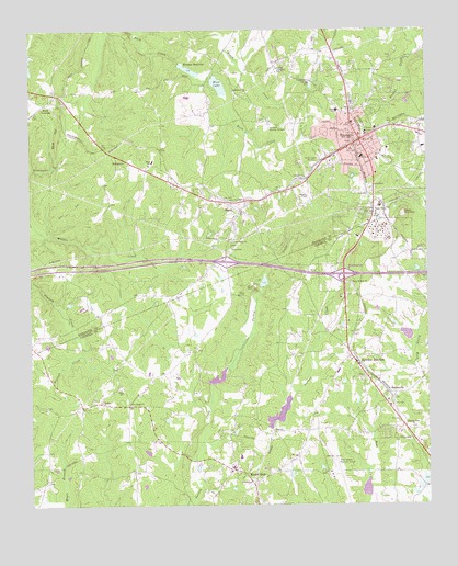
Bremen, GA USGS Topographic Map
Click on map above to begin viewing in our Map Viewer.

This topographic map contains these locations and features:
Feature Name Type Latitude Longitude GNIS ID View Map
Antioch CemeteryCemeteryN33.7109°W85.1636°350614View Map
Antioch ChurchChurchN33.7112°W85.1633°354359View Map
Bethlehem Baptist ChurchChurchN33.6584°W85.1455°350065View Map
Bethlehem CemeteryCemeteryN33.6590°W85.1455°350066View Map
Bethlehem ChurchChurchN33.7340°W85.1855°354680View Map
Bowdon JunctionPopulated PlaceN33.6632°W85.1469°331213View Map
BremenPopulated PlaceN33.7212°W85.1455°354845View Map
Bremen Crossroads AcademySchoolN33.7190°W85.1402°2545691View Map
Bremen DivisionCivilN33.7314°W85.1480°1936128View Map
Bremen Fire Department Station 61BuildingN33.7233°W85.1420°2603554View Map
Bremen High SchoolSchoolN33.7177°W85.1389°2545783View Map
Bremen Police DepartmentBuildingN33.7236°W85.1419°2733766View Map
Bremen Post OfficePost OfficeN33.7204°W85.1491°350618View Map
Bremen ReservoirReservoirN33.7397°W85.1996°311750View Map
Bremen Reservoir Lake DamDamN33.7418°W85.2024°337657View Map
BudapestPopulated PlaceN33.7151°W85.2180°331274View Map
Bush CreekStreamN33.7496°W85.2147°312080View Map
Camp WacoLocaleN33.6821°W85.1791°312265View Map
Camp Waco LakeReservoirN33.6836°W85.1765°339660View Map
Camp Waco Lake DamDamN33.6834°W85.1766°339659View Map
Carroll County Crossroads Middle SchoolSchoolN33.6350°W85.1865°2545545View Map
Carroll County Fire / Rescue Station 7BuildingN33.6338°W85.1738°2603984View Map
City of BremenCivilN33.7090°W85.1493°2403917View Map
City of Mount ZionCivilN33.6408°W85.1800°2404328View Map
City of WacoCivilN33.7026°W85.1892°2405657View Map
First Baptist Church of BremenChurchN33.7257°W85.1483°350633View Map
Five Points CemeteryCemeteryN33.6515°W85.2183°350147View Map
Five Points ChurchChurchN33.6515°W85.2188°355812View Map
Godwin Lake DamDamN33.7434°W85.2500°339943View Map
Haralson County Fire Department Station 7BuildingN33.7426°W85.1701°2604456View Map
Haralson Memory GardensCemeteryN33.7243°W85.1752°315106View Map
Higgins General HospitalHospitalN33.7166°W85.1451°350640View Map
Holland School (historical)SchoolN33.7340°W85.1852°350641View Map
Holly Springs CemeteryCemeteryN33.6834°W85.1502°349599View Map
Holly Springs ChurchChurchN33.6834°W85.1494°315572View Map
Interchange 2CrossingN33.6890°W85.1883°350643View Map
Interchange ThreeCrossingN33.6854°W85.1511°349603View Map
JakePopulated PlaceN33.6521°W85.2274°332085View Map
Jake School (historical)SchoolN33.6509°W85.2191°349606View Map
Jones Elementary SchoolSchoolN33.7286°W85.1528°316255View Map
Little Turkey CreekStreamN33.6407°W85.1966°317226View Map
MandevillePopulated PlaceN33.6546°W85.1369°332311View Map
Miller LakeReservoirN33.6317°W85.1260°339919View Map
Miller Lake DamDamN33.6301°W85.1266°339918View Map
Mount ZionPopulated PlaceN33.6343°W85.1872°332438View Map
Mount Zion DivisionCivilN33.6404°W85.1794°1936424View Map
Mount Zion High SchoolSchoolN33.6379°W85.1844°349657View Map
Mount Zion Middle SchoolSchoolN33.6376°W85.1844°2545510View Map
Mount Zion Police DepartmentBuildingN33.6344°W85.1856°2734018View Map
Muse LakeReservoirN33.6583°W85.1914°339920View Map
New Hope ChurchChurchN33.6943°W85.1858°319423View Map
Pleasant Hill CemeteryCemeteryN33.6454°W85.1291°349691View Map
Pleasant View ChurchChurchN33.6451°W85.1297°320945View Map
Reeds MountainSummitN33.7018°W85.1324°332820View Map
Swims LakeReservoirN33.6293°W85.1444°339356View Map
Union Camp GroundLocaleN33.6562°W85.2224°349745View Map
Union Camp Ground CemeteryCemeteryN33.6565°W85.2211°349746View Map
Union ChurchChurchN33.6554°W85.2213°324534View Map
WacoPopulated PlaceN33.7029°W85.1833°333338View Map
Waco Fire DepartmentBuildingN33.7018°W85.1839°2603799View Map
Waco Post OfficePost OfficeN33.7032°W85.1824°350730View Map
Waco SchoolSchoolN33.7154°W85.2108°324732View Map
Waco Sheriff's DepartmentBuildingN33.7009°W85.1855°2733901View Map
WBKI-AM (Bremen)TowerN33.7157°W85.1594°352371View Map
West Central Technical CollegeSchoolN33.6919°W85.1837°2545818View Map
West CrossingPopulated PlaceN33.7307°W85.2447°333391View Map
West Georgia Regional Airport - O V Gray FieldAirportN33.6342°W85.1560°351705View Map
West HillSummitN33.7229°W85.2411°333393View Map
West LakeReservoirN33.7357°W85.1903°325057View Map
West Lake DamDamN33.7376°W85.1922°337655View Map

Note: Coordinates in the location and feature list above are referenced to NAD83 datum.


Copyright (C) 2008-2025 Ryan Niemi / Sunset Dynamics ... All Rights Reserved