TopoQuest Logo
Do you find TopoQuest useful?
Help keep TopoQuest running and adding new maps/features by donating!
Bitcoin:  19c7KJd3qBynnjoSw5npx9KScwjBe4ifkT
Litecoin:  LXs6TkuXGGXo1vDsWCkWVdjQX94eUKd6ui
Home View Maps Find Maps Find Places Resources & Links


Brewer, Mississippi Topographic Map

USGS Map Title: Brewer, MS
USGS Map MRC: 31088C7
DRG (GeoTIFF) Download: o31088c7.tif


Neighboring USGS Topographic Map Quads:


  Rhodes, MS  
31088D8
 

  Mulberry, MS  
31088D7
 

  Piave, MS  
31088D6
 

  Richton, MS  
31088C8
 

  Brewer, MS  
31088C7
 

  Avera, MS  
31088C6
 

  Beaumont, MS  
31088B8
 

  Neely, MS  
31088B7
 

  Jonathan, MS  
31088B6


Map MRC Location:

N32°
W89°
N32°
W88°
H8 H7 H6 H5 H4 H3 H2 H1
G8 G7 G6 G5 G4 G3 G2 G1
F8 F7 F6 F5 F4 F3 F2 F1
E8 E7 E6 E5 E4 E3 E2 E1
D8 D7 D6 D5 D4 D3 D2 D1
C8 C7 C6 C5 C4 C3 C2 C1
B8 B7 B6 B5 B4 B3 B2 B1
A8 A7 A6 A5 A4 A3 A2 A1
N31°
W89°
N31°
W88°

Brewer, MS USGS 1:24K Topographic Map Preview:
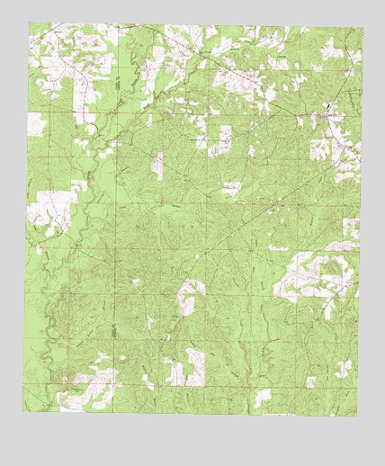
Brewer, MS USGS Topographic Map
Click on map above to begin viewing in our Map Viewer.

This topographic map contains these locations and features:
Feature Name Type Latitude Longitude GNIS ID View Map
Avera ChurchChurchN31.2930°W88.7523°666434View Map
Beetree CreekStreamN31.3599°W88.8125°666764View Map
Boykin CreekStreamN31.2568°W88.7911°667499View Map
BrewerPopulated PlaceN31.3727°W88.8664°691726View Map
Brewer School (historical)SchoolN31.3705°W88.8625°683353View Map
Fivemile CreekStreamN31.2577°W88.7900°670007View Map
Freeman School (historical)SchoolN31.3655°W88.8178°686448View Map
Frisco CemeteryCemeteryN31.3563°W88.8525°670255View Map
Gaines Brewer Road BridgeBridgeN31.3390°W88.8481°2596597View Map
Little Gaines CreekStreamN31.3121°W88.8506°672612View Map
Long BranchStreamN31.2952°W88.8667°693816View Map
Lower Flat BranchStreamN31.2568°W88.7911°672914View Map
Nazareth ChurchChurchN31.2574°W88.8567°674525View Map
Newcomb BranchStreamN31.3135°W88.8517°674898View Map
Piney Woods CreekStreamN31.3346°W88.8489°694404View Map
Sand HillPopulated PlaceN31.3468°W88.7636°677340View Map
Sand Hill Baptist ChurchChurchN31.3472°W88.7640°2597116View Map
Sand Hill CemeteryCemeteryN31.3399°W88.7598°677343View Map
Sand Hill CreekStreamN31.3346°W88.8489°694693View Map
Sand Hill Creek ChurchChurchN31.3660°W88.8112°677350View Map
Sand Hill Volunteer Fire DepartmentBuildingN31.3488°W88.7617°2332860View Map
Supervisor District 3CivilN31.3352°W88.7510°711860View Map
Upper Flat BranchStreamN31.2857°W88.7856°679148View Map
Yellow Jacket BranchStreamN31.2727°W88.8625°679944View Map
Zion Rest ChurchChurchN31.3382°W88.8100°680036View Map

Note: Coordinates in the location and feature list above are referenced to NAD83 datum.


Copyright (C) 2008-2024 Ryan Niemi / Sunset Dynamics ... All Rights Reserved