TopoQuest Logo
Do you find TopoQuest useful?
Help keep TopoQuest running and adding new maps/features by donating!
Bitcoin:  19c7KJd3qBynnjoSw5npx9KScwjBe4ifkT
Litecoin:  LXs6TkuXGGXo1vDsWCkWVdjQX94eUKd6ui
Home View Maps Find Maps Find Places Resources & Links


Jonathan, Mississippi Topographic Map

USGS Map Title: Jonathan, MS
USGS Map MRC: 31088B6
DRG (GeoTIFF) Download: o31088b6.tif


Neighboring USGS Topographic Map Quads:


  Brewer, MS  
31088C7
 

  Avera, MS  
31088C6
 

  Clark, MS  
31088C5
 

  Neely, MS  
31088B7
 

  Jonathan, MS  
31088B6
 

  Leakesville, MS  
31088B5
 

  McLain, MS  
31088A7
 

  Leakesville SW, MS  
31088A6
 

  Vernal, MS  
31088A5


Map MRC Location:

N32°
W89°
N32°
W88°
H8 H7 H6 H5 H4 H3 H2 H1
G8 G7 G6 G5 G4 G3 G2 G1
F8 F7 F6 F5 F4 F3 F2 F1
E8 E7 E6 E5 E4 E3 E2 E1
D8 D7 D6 D5 D4 D3 D2 D1
C8 C7 C6 C5 C4 C3 C2 C1
B8 B7 B6 B5 B4 B3 B2 B1
A8 A7 A6 A5 A4 A3 A2 A1
N31°
W89°
N31°
W88°

Jonathan, MS USGS 1:24K Topographic Map Preview:
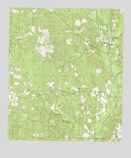
Jonathan, MS USGS Topographic Map
Click on map above to begin viewing in our Map Viewer.

This topographic map contains these locations and features:
Feature Name Type Latitude Longitude GNIS ID View Map
BradleyPopulated PlaceN31.1752°W88.6714°691725View Map
Bradley CemeteryCemeteryN31.1905°W88.7492°707706View Map
ByrdPopulated PlaceN31.2202°W88.7398°691744View Map
Cedar Grove Baptist ChurchChurchN31.2233°W88.6384°2596737View Map
Church of Jesus ChristChurchN31.1280°W88.6664°668481View Map
Corinth ChurchChurchN31.1466°W88.6564°668829View Map
Deep BranchStreamN31.1868°W88.6322°669191View Map
Green Lookout TowerTowerN31.2180°W88.7023°711236View Map
Greene CountyCivilN31.2142°W88.6392°695745View Map
HillmanPopulated PlaceN31.1335°W88.6328°691934View Map
Hillman CemeteryCemeteryN31.1502°W88.6511°671225View Map
Indian CreekStreamN31.1316°W88.6536°671677View Map
JonathanPopulated PlaceN31.2227°W88.6375°691972View Map
Jonathan Volunteer Fire DepartmentBuildingN31.2214°W88.6671°2667919View Map
Kittrell Mill CreekStreamN31.2255°W88.6431°693665View Map
Little CreekStreamN31.1355°W88.6547°672578View Map
Long BranchStreamN31.1991°W88.6367°672806View Map
Long BranchStreamN31.2352°W88.6250°693815View Map
Mason CreekStreamN31.2107°W88.6400°693888View Map
Supervisor District 5CivilN31.1517°W88.7481°711862View Map
Wilson (historical)Populated PlaceN31.1849°W88.7445°686465View Map
Wolf BranchStreamN31.2468°W88.6842°695203View Map

Note: Coordinates in the location and feature list above are referenced to NAD83 datum.


Copyright (C) 2008-2024 Ryan Niemi / Sunset Dynamics ... All Rights Reserved