TopoQuest Logo
Do you find TopoQuest useful?
Help keep TopoQuest running and adding new maps/features by donating!
Bitcoin:  19c7KJd3qBynnjoSw5npx9KScwjBe4ifkT
Litecoin:  LXs6TkuXGGXo1vDsWCkWVdjQX94eUKd6ui
Home View Maps Find Maps Find Places Resources & Links


Alicia, Michigan Topographic Map

USGS Map Title: Alicia, MI
USGS Map MRC: 43084C1
DRG (GeoTIFF) Download: o43084c1.tif


Neighboring USGS Topographic Map Quads:


  Hemlock, MI  
43084D2
 

  Shields, MI  
43084D1
 

  Saginaw, MI  
43083D8
 

  Saint Charles, MI  
43084C2
 

  Alicia, MI  
43084C1
 

  Bridgeport, MI  
43083C8
 

  Chesaning West, MI  
43084B2
 

  Chesaning East, MI  
43084B1
 

  Montrose, MI  
43083B8


Map MRC Location:

N44°
W85°
N44°
W84°
H8 H7 H6 H5 H4 H3 H2 H1
G8 G7 G6 G5 G4 G3 G2 G1
F8 F7 F6 F5 F4 F3 F2 F1
E8 E7 E6 E5 E4 E3 E2 E1
D8 D7 D6 D5 D4 D3 D2 D1
C8 C7 C6 C5 C4 C3 C2 C1
B8 B7 B6 B5 B4 B3 B2 B1
A8 A7 A6 A5 A4 A3 A2 A1
N43°
W85°
N43°
W84°

Alicia, MI USGS 1:24K Topographic Map Preview:
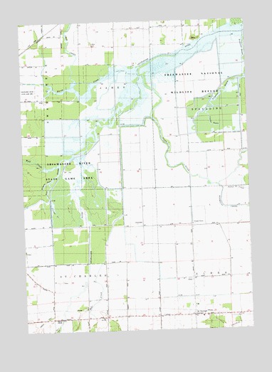
Alicia, MI USGS Topographic Map
Click on map above to begin viewing in our Map Viewer.

This topographic map contains these locations and features:
Feature Name Type Latitude Longitude GNIS ID View Map
AliciaPopulated PlaceN43.2709°W84.0325°1617411View Map
Alicia Post Office (historical)Post OfficeN43.2708°W84.0325°2558586View Map
Bad RiverStreamN43.3236°W84.0894°620425View Map
Bear CreekStreamN43.2975°W84.0703°620831View Map
Carson DrainStreamN43.2772°W84.1086°622796View Map
ClausedalePopulated PlaceN43.2925°W84.0594°1617491View Map
Cole DitchCanalN43.3459°W84.0036°623584View Map
Crystal BayouLakeN43.3321°W84.0168°624162View Map
Deer CreekStreamN43.2528°W84.1069°624460View Map
Fairchild CreekStreamN43.3397°W84.0708°625748View Map
Flint RiverStreamN43.3534°W84.0600°626175View Map
Indiantown CemeteryCemeteryN43.2555°W84.0797°2558995View Map
Kimberly BayouLakeN43.3106°W84.1109°629678View Map
Marsh CreekStreamN43.3556°W84.0653°631612View Map
McDonough CornersLocaleN43.2561°W84.0319°631789View Map
McDonough Post Office (historical)Post OfficeN43.2561°W84.0319°2558482View Map
Misteguay CreekStreamN43.3084°W84.0175°632507View Map
Pattee CreekStreamN43.3075°W84.0147°634461View Map
Pickerel CreekStreamN43.3028°W84.1100°634774View Map
Prairie FarmLocaleN43.2928°W84.0316°635391View Map
Saginaw CountyCivilN43.3350°W84.0532°1623015View Map
Saint Mary Church of AlbeeChurchN43.2556°W84.0272°2558714View Map
Shiawassee National Wildlife RefugeParkN43.3576°W84.0035°637791View Map
Shiawassee River State Game AreaParkN43.3150°W84.1033°637794View Map
Swan CreekStreamN43.3509°W84.0941°639150View Map
Township of JamesCivilN43.3629°W84.0540°1626536View Map
Township of Saint CharlesCivilN43.2626°W84.1108°1627023View Map
Wolf CreekStreamN43.3172°W84.1061°1616685View Map

Note: Coordinates in the location and feature list above are referenced to NAD83 datum.


Copyright (C) 2008-2024 Ryan Niemi / Sunset Dynamics ... All Rights Reserved