TopoQuest Logo
Do you find TopoQuest useful?
Help keep TopoQuest running and adding new maps/features by donating!
Bitcoin:  19c7KJd3qBynnjoSw5npx9KScwjBe4ifkT
Litecoin:  LXs6TkuXGGXo1vDsWCkWVdjQX94eUKd6ui
Home View Maps Find Maps Find Places Resources & Links


Garland, Alabama Topographic Map

USGS Map Title: Garland, AL
USGS Map MRC: 31086E7
DRG (GeoTIFF) Download: o31086e7.tif


Neighboring USGS Topographic Map Quads:


  Bethel, AL  
31086F8
 

  Georgiana West, AL  
31086F7
 

  Georgiana East, AL  
31086F6
 

  Lyeffion, AL  
31086E8
 

  Garland, AL  
31086E7
 

  McKenzie, AL  
31086E6
 

  Evergreen, AL  
31086D8
 

  Old Town, AL  
31086D7
 

  Brooks, AL  
31086D6


Map MRC Location:

N32°
W87°
N32°
W86°
H8 H7 H6 H5 H4 H3 H2 H1
G8 G7 G6 G5 G4 G3 G2 G1
F8 F7 F6 F5 F4 F3 F2 F1
E8 E7 E6 E5 E4 E3 E2 E1
D8 D7 D6 D5 D4 D3 D2 D1
C8 C7 C6 C5 C4 C3 C2 C1
B8 B7 B6 B5 B4 B3 B2 B1
A8 A7 A6 A5 A4 A3 A2 A1
N31°
W87°
N31°
W86°

Garland, AL USGS 1:24K Topographic Map Preview:
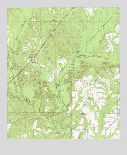
Garland, AL USGS Topographic Map
Click on map above to begin viewing in our Map Viewer.

This topographic map contains these locations and features:
Feature Name Type Latitude Longitude GNIS ID View Map
Alexander PondLakeN31.6016°W86.7561°134986View Map
Belmont Number 1 ChurchChurchN31.5535°W86.8378°164023View Map
Belmont Number 2 ChurchChurchN31.5729°W86.8436°164024View Map
Duck CreekStreamN31.5585°W86.8680°117612View Map
Dunham (historical)LocaleN31.5946°W86.7778°155358View Map
Exit 107CrossingN31.5765°W86.8464°155650View Map
GarlandPopulated PlaceN31.5566°W86.8233°118835View Map
Garland CemeteryCemeteryN31.5763°W86.8314°118836View Map
Garland ChurchChurchN31.5610°W86.8216°163362View Map
Garland School (historical)SchoolN31.5660°W86.8236°164478View Map
Garland Volunteer Fire DepartmentBuildingN31.5574°W86.8224°2691534View Map
Lake AlexanderReservoirN31.5898°W86.7639°129894View Map
Lake Alexander Dam Number OneDamN31.5885°W86.7650°129895View Map
Long ChurchChurchN31.6240°W86.8264°152146View Map
Long CreekStreamN31.5779°W86.8744°122005View Map
Long Creek School (historical)SchoolN31.6215°W86.8244°135024View Map
Long Creek TempleChurchN31.6124°W86.8228°152147View Map
Maye CemeteryCemeteryN31.6074°W86.8208°164169View Map
McClure CemeteryCemeteryN31.5560°W86.8022°122478View Map
Mount OlivePopulated PlaceN31.5785°W86.8480°123276View Map
Odom CrossroadsPopulated PlaceN31.5379°W86.7861°156824View Map
Panther CreekStreamN31.5804°W86.7789°124417View Map
Persimmon CreekStreamN31.5163°W86.8258°155192View Map
Pleasant Hill CemeteryCemeteryN31.5410°W86.7525°124973View Map
Pleasant Home ChurchChurchN31.5460°W86.8011°125020View Map
Pressley CemeteryCemeteryN31.5982°W86.8272°135047View Map
Saint John ChurchChurchN31.5688°W86.8380°126112View Map
SalterPopulated PlaceN31.5466°W86.7819°135055View Map
Sellers CemeteryCemeteryN31.5943°W86.7619°126536View Map
Walker CemeteryCemeteryN31.5079°W86.7994°149672View Map
Wiggins School (historical)SchoolN31.5110°W86.7841°133201View Map

Note: Coordinates in the location and feature list above are referenced to NAD83 datum.


Copyright (C) 2008-2024 Ryan Niemi / Sunset Dynamics ... All Rights Reserved