TopoQuest Logo
Do you find TopoQuest useful?
Help keep TopoQuest running and adding new maps/features by donating!
Bitcoin:  19c7KJd3qBynnjoSw5npx9KScwjBe4ifkT
Litecoin:  LXs6TkuXGGXo1vDsWCkWVdjQX94eUKd6ui
Home View Maps Find Maps Find Places Resources & Links


Central Mills, Alabama Topographic Map

USGS Map Title: Central Mills, AL
USGS Map MRC: 32087C4
DRG (GeoTIFF) Download: o32087c4.tif


Neighboring USGS Topographic Map Quads:


  Uniontown West, AL  
32087D5
 

  Uniontown East, AL  
32087D4
 

  Browns, AL  
32087D3
 

  Thomaston East, AL  
32087C5
 

  Central Mills, AL  
32087C4
 

  Safford, AL  
32087C3
 

  Flatwood, AL  
32087B5
 

  Catherine, AL  
32087B4
 

  Crumptonia, AL  
32087B3


Map MRC Location:

N33°
W88°
N33°
W87°
H8 H7 H6 H5 H4 H3 H2 H1
G8 G7 G6 G5 G4 G3 G2 G1
F8 F7 F6 F5 F4 F3 F2 F1
E8 E7 E6 E5 E4 E3 E2 E1
D8 D7 D6 D5 D4 D3 D2 D1
C8 C7 C6 C5 C4 C3 C2 C1
B8 B7 B6 B5 B4 B3 B2 B1
A8 A7 A6 A5 A4 A3 A2 A1
N32°
W88°
N32°
W87°

Central Mills, AL USGS 1:24K Topographic Map Preview:
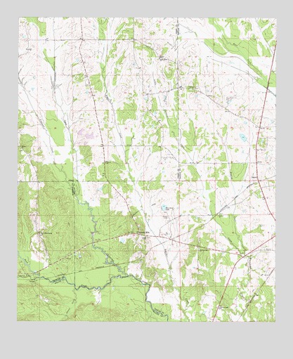
Central Mills, AL USGS Topographic Map
Click on map above to begin viewing in our Map Viewer.

This topographic map contains these locations and features:
Feature Name Type Latitude Longitude GNIS ID View Map
Aimwell Baptist ChurchChurchN32.3154°W87.4575°112948View Map
Black BeltAreaN32.3335°W87.4167°148954View Map
BlalockPopulated PlaceN32.3093°W87.3836°156074View Map
Bon Aire LakeReservoirN32.2972°W87.4291°114708View Map
Bushy Oak (historical)LocaleN32.3668°W87.4686°149863View Map
C Shuptrine DamDamN32.2985°W87.4283°130388View Map
Canaan Baptist ChurchChurchN32.3210°W87.4986°115521View Map
CarleysPopulated PlaceN32.2671°W87.4914°156149View Map
Center ChapelChurchN32.2851°W87.4378°155018View Map
Central MillsPopulated PlaceN32.2863°W87.4408°156163View Map
Central Mills Station (historical)LocaleN32.2757°W87.4411°144537View Map
Christian Light CemeteryCemeteryN32.2799°W87.4119°154735View Map
Christian Light ChurchChurchN32.2560°W87.4019°116099View Map
Christian Light ChurchChurchN32.2796°W87.4122°116100View Map
Concord ChurchChurchN32.2940°W87.4025°116488View Map
Concord ChurchChurchN32.3537°W87.3767°116489View Map
County Line CreekStreamN32.2682°W87.4894°116737View Map
English CreekStreamN32.2785°W87.3903°117990View Map
Freetown CreekStreamN32.3021°W87.4714°118632View Map
Glover CreekStreamN32.2638°W87.4717°119058View Map
Johnsons Mill (historical)LocaleN32.3468°W87.4328°144590View Map
Little Canaan School (historical)SchoolN32.3201°W87.4894°149888View Map
Miller Brothers Dam Number OneDamN32.3268°W87.4717°130433View Map
Miller Brothers Dam Number ThreeDamN32.3251°W87.4683°130430View Map
Miller Brothers Dam Number TwoDamN32.3285°W87.4717°130437View Map
Miller Brothers Lake Number OneReservoirN32.3268°W87.4717°130434View Map
Miller Brothers Lake Number ThreeReservoirN32.3244°W87.4693°130431View Map
Miller Brothers Lake Number TwoReservoirN32.3285°W87.4717°130438View Map
Mount Zion CemeteryCemeteryN32.2793°W87.4397°154736View Map
New Bethel Spring ChurchChurchN32.2863°W87.4892°152609View Map
New Bethel Springs CemeteryCemeteryN32.2865°W87.4894°1867928View Map
Pine Grove ChurchChurchN32.2860°W87.4464°124787View Map
Popes Beat School (historical)SchoolN32.3546°W87.4681°149862View Map
Saint James ChurchChurchN32.3462°W87.4147°126103View Map
Sand CreekStreamN32.2690°W87.4456°126306View Map
Sand Creek Dam Number OneDamN32.2768°W87.4700°130369View Map
Sand Creek Lake Number OneReservoirN32.2770°W87.4696°130370View Map
Shady Grove ChurchChurchN32.3585°W87.4317°126606View Map
Signature ChurchChurchN32.2501°W87.4572°138590View Map
Triangle 6 Ranch DamDamN32.3251°W87.3867°130428View Map
Triangle 6 Ranch LakeReservoirN32.3251°W87.3867°130429View Map
Walkers Quarter (historical)LocaleN32.3515°W87.4500°149861View Map

Note: Coordinates in the location and feature list above are referenced to NAD83 datum.


Copyright (C) 2008-2025 Ryan Niemi / Sunset Dynamics ... All Rights Reserved