TopoQuest Logo
Do you find TopoQuest useful?
Help keep TopoQuest running and adding new maps/features by donating!
Bitcoin:  19c7KJd3qBynnjoSw5npx9KScwjBe4ifkT
Litecoin:  LXs6TkuXGGXo1vDsWCkWVdjQX94eUKd6ui
Home View Maps Find Maps Find Places Resources & Links


Brownsville, Minnesota Topographic Map

USGS Map Title: Brownsville, MN
USGS Map MRC: 43091F3
DRG (GeoTIFF) Download: o43091f3.tif


Neighboring USGS Topographic Map Quads:


  Mound Prairie, MN  
43091G4
 

  La Crescent, MN  
43091G3
 

  La Crosse, WI  
43091G2
 

  Caledonia, MN  
43091F4
 

  Brownsville, MN  
43091F3
 

  Stoddard, WI  
43091F2
 

  Eitzen, MN  
43091E4
 

  Reno, MN  
43091E3
 

  Genoa, WI  
43091E2


Map MRC Location:

N44°
W92°
N44°
W91°
H8 H7 H6 H5 H4 H3 H2 H1
G8 G7 G6 G5 G4 G3 G2 G1
F8 F7 F6 F5 F4 F3 F2 F1
E8 E7 E6 E5 E4 E3 E2 E1
D8 D7 D6 D5 D4 D3 D2 D1
C8 C7 C6 C5 C4 C3 C2 C1
B8 B7 B6 B5 B4 B3 B2 B1
A8 A7 A6 A5 A4 A3 A2 A1
N43°
W92°
N43°
W91°

Brownsville, MN USGS 1:24K Topographic Map Preview:
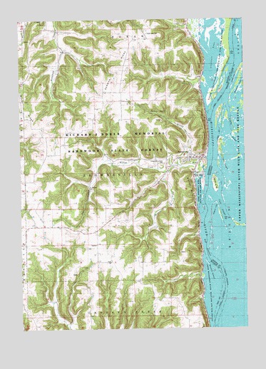
Brownsville, MN USGS Topographic Map
Click on map above to begin viewing in our Map Viewer.

This topographic map contains these locations and features:
Feature Name Type Latitude Longitude GNIS ID View Map
Benover SloughGutN43.6618°W91.2627°2746957View Map
Bluff View FarmLocaleN43.7328°W91.3544°2674523View Map
Broken Bow IslandIslandN43.6576°W91.2669°2729511View Map
Browns IslandIslandN43.6469°W91.2696°640541View Map
BrownsvillePopulated PlaceN43.6941°W91.2799°640547View Map
BrownsvilleLocaleN43.6944°W91.2732°2050578View Map
Brownsville City HallBuildingN43.6936°W91.2779°2050577View Map
Brownsville CreekStreamN43.6886°W91.2926°640548View Map
Brownsville Fire and Rescue DepartmentBuildingN43.6944°W91.2762°2666322View Map
Brownsville Post OfficePost OfficeN43.6943°W91.2784°2050580View Map
Cant Hook IslandIslandN43.6515°W91.2716°2729513View Map
Christoph Hammer Family CemeteryCemeteryN43.7416°W91.3029°2050419View Map
City of BrownsvilleCivilN43.6993°W91.2823°2393441View Map
Coon SloughGutN43.6721°W91.2623°2729290View Map
Crosby SloughGutN43.7079°W91.2576°2729288View Map
Cygnet IslandIslandN43.6381°W91.2720°2729522View Map
Dabbler IslandIslandN43.6433°W91.2687°2729520View Map
Evangelical Lutheran CemeteryCemeteryN43.6916°W91.2951°643442View Map
Forest Green CemeteryCemeteryN43.7441°W91.3035°643797View Map
Frederick Hammer Family CemeteryCemeteryN43.7383°W91.2932°2050418View Map
German RidgeRidgeN43.7327°W91.3157°644100View Map
Hackett's Grove CemeteryCemeteryN43.6680°W91.3710°2050425View Map
Heelsplitter IslandIslandN43.6322°W91.2584°2747246View Map
Island One Hundred TwentyIslandN43.6716°W91.2645°2729287View Map
Jewelwing IslandIslandN43.6258°W91.2637°2747247View Map
KKOO-FM (Caledonia)TowerN43.6780°W91.3690°663289View Map
Lawrence LakeLakeN43.7344°W91.2675°646536View Map
Little Crosby SloughGutN43.6932°W91.2631°2729289View Map
Miller RidgeRidgeN43.7086°W91.3710°647882View Map
Muskrat LakeGutN43.7218°W91.2537°2729291View Map
Musquash IslandIslandN43.6398°W91.2523°2747249View Map
Neumann Family CemeteryCemeteryN43.6666°W91.3112°2050424View Map
Raft ChannelChannelN43.6577°W91.2724°649794View Map
Raft IslandIslandN43.6406°W91.2651°2729517View Map
Rediske DairyLocaleN43.7211°W91.3175°2674521View Map
Saint Patrick ParishChurchN43.6941°W91.2799°2050581View Map
Saint Patricks CemeteryCemeteryN43.6808°W91.3354°650944View Map
Snake Tongue IslandIslandN43.6518°W91.2573°2729515View Map
Soft Shell IslandIslandN43.6312°W91.2637°2747251View Map
Spring BranchStreamN43.6900°W91.2849°652421View Map
Township of BrownsvilleCivilN43.6883°W91.3225°663686View Map
Turtle IslandIslandN43.6667°W91.2552°2729285View Map
Veterans CemeteryCemeteryN43.6913°W91.2926°2050439View Map
Ward Lee Mobile Home ParkPopulated PlaceN43.6941°W91.2799°2050582View Map
Warner Post Light (historical)BuildingN43.6576°W91.2739°2652387View Map
Wildcat BluffCliffN43.6814°W91.2799°654138View Map
Wildcat CreekStreamN43.6894°W91.2774°654139View Map
Wildcat Landing CampgroundLocaleN43.6861°W91.2726°2050579View Map
Wildcat Landing Public AccessLocaleN43.6869°W91.2729°655010View Map
Wildcat ParkParkN43.6903°W91.2739°2729293View Map
Willow Sprig IslandIslandN43.6374°W91.2609°2747252View Map
Zion Evangelical ChurchChurchN43.6941°W91.2799°2050583View Map

Note: Coordinates in the location and feature list above are referenced to NAD83 datum.


Copyright (C) 2008-2024 Ryan Niemi / Sunset Dynamics ... All Rights Reserved