TopoQuest Logo
Do you find TopoQuest useful?
Help keep TopoQuest running and adding new maps/features by donating!
Bitcoin:  19c7KJd3qBynnjoSw5npx9KScwjBe4ifkT
Litecoin:  LXs6TkuXGGXo1vDsWCkWVdjQX94eUKd6ui
Home View Maps Find Maps Find Places Resources & Links


Bruceton, Tennessee Topographic Map

USGS Map Title: Bruceton, TN
USGS Map MRC: 36088A2
DRG (GeoTIFF) Download: o36088a2.tif


Neighboring USGS Topographic Map Quads:


  Mansfield, TN  
36088B3
 

  Manleyville, TN  
36088B2
 

  Big Sandy, TN  
36088B1
 

  Vale, TN  
36088A3
 

  Bruceton, TN  
36088A2
 

  Camden, TN  
36088A1
 

  Buena Vista, TN  
35088H3
 

  Seventeen Creek, TN  
35088H2
 

  Rockport, TN  
35088H1


Map MRC Location:

N37°
W89°
N37°
W88°
H8 H7 H6 H5 H4 H3 H2 H1
G8 G7 G6 G5 G4 G3 G2 G1
F8 F7 F6 F5 F4 F3 F2 F1
E8 E7 E6 E5 E4 E3 E2 E1
D8 D7 D6 D5 D4 D3 D2 D1
C8 C7 C6 C5 C4 C3 C2 C1
B8 B7 B6 B5 B4 B3 B2 B1
A8 A7 A6 A5 A4 A3 A2 A1
N36°
W89°
N36°
W88°

Bruceton, TN USGS 1:24K Topographic Map Preview:
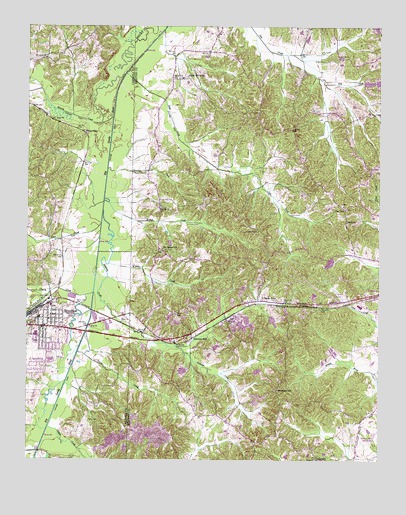
Bruceton, TN USGS Topographic Map
Click on map above to begin viewing in our Map Viewer.

This topographic map contains these locations and features:
Feature Name Type Latitude Longitude GNIS ID View Map
Allen CreekStreamN36.0681°W88.2242°1304803View Map
Britton CreekStreamN36.0748°W88.2231°1278424View Map
BrucetonPopulated PlaceN36.0381°W88.2445°1305469View Map
Bruceton Police DepartmentBuildingN36.0409°W88.2450°2765927View Map
Bruceton Post OfficePost OfficeN36.0409°W88.2443°1651401View Map
Bruceton Volunteer Fire DepartmentBuildingN36.0409°W88.2451°2653667View Map
C H Sullins DamDamN36.0417°W88.1634°1302335View Map
C H Sullins LakeReservoirN36.0402°W88.1627°1302334View Map
Cedar Grove CemeteryCemeteryN36.1103°W88.1942°1644687View Map
Cedar Grove ChurchChurchN36.1106°W88.1939°1305768View Map
Cedar Lake Dam Number OneDamN36.1092°W88.1264°1307189View Map
Cedar Lake Dam Number TwoDamN36.1092°W88.1306°1307191View Map
Cedar Lake Number TwoReservoirN36.1089°W88.1286°1307190View Map
Cherry CreekStreamN36.0481°W88.2267°1280342View Map
Cole LakeReservoirN36.0256°W88.1947°1302318View Map
Cole Lake DamDamN36.0251°W88.1934°1302319View Map
Commissioner District 2CivilN36.1063°W88.1498°2463896View Map
Cotton CreekStreamN36.0092°W88.2423°1281357View Map
Cotton Creek School (historical)SchoolN36.0184°W88.2281°1320322View Map
Cross Roads School (historical)SchoolN36.0012°W88.1478°1316820View Map
CrossroadsPopulated PlaceN36.0006°W88.1475°1281721View Map
Crossroads Baptist ChurchChurchN36.0006°W88.1478°1644694View Map
Crossroads CemeteryCemeteryN36.0003°W88.1478°1644695View Map
District 16 (historical)CivilN36.0584°W88.2487°1325889View Map
District 17 (historical)CivilN36.1167°W88.2487°1325890View Map
Garfield School (historical)SchoolN36.0578°W88.2042°1316831View Map
Green CreekStreamN36.0309°W88.2320°1286086View Map
Greer CemeteryCemeteryN36.1151°W88.1448°1286215View Map
Hardy Sand Company DamDamN36.0401°W88.1750°1302333View Map
Hardy Sand Company LakeReservoirN36.0385°W88.1737°1302332View Map
Hollow Rock BranchStreamN36.0481°W88.2425°1288082View Map
Hunting CreekStreamN36.0720°W88.2234°1288758View Map
Lick CreekStreamN36.1114°W88.2156°1291206View Map
LipePopulated PlaceN36.0409°W88.1795°1315410View Map
Martin CreekStreamN36.0989°W88.2203°1303495View Map
Mount Carmel CemeteryCemeteryN36.0601°W88.2017°1644716View Map
Mount Carmel ChurchChurchN36.0609°W88.2023°1294588View Map
Parks CemeteryCemeteryN36.0109°W88.2284°1296850View Map
Pea RidgeRidgeN36.0028°W88.1531°1310615View Map
Pleasant Grove Church (historical)ChurchN36.0601°W88.1923°1316868View Map
Post OakPopulated PlaceN36.0726°W88.1370°1315770View Map
Post Oak CemeteryCemeteryN36.0737°W88.1384°1644731View Map
Post Oak Methodist ChurchChurchN36.0731°W88.1381°1644732View Map
Post Oak School (historical)SchoolN36.0720°W88.1373°1316873View Map
Priests SpurLocaleN36.0948°W88.2306°1298529View Map
ProspectPopulated PlaceN36.0951°W88.1556°1310630View Map
Prospect Baptist ChurchChurchN36.1006°W88.1675°1644733View Map
Prospect School (historical)SchoolN36.0956°W88.1562°1316874View Map
Sandy PointPopulated PlaceN36.0462°W88.1681°1300766View Map
Sandy Point CemeteryCemeteryN36.0473°W88.1661°1644736View Map
Sandy Point ChurchChurchN36.0470°W88.1664°1644737View Map
Sandy Point School (historical)SchoolN36.0464°W88.1664°1316880View Map
Sawyers MillPopulated PlaceN36.0364°W88.1920°1300854View Map
Smuthers CreekStreamN36.0839°W88.2220°1270732View Map
Snider (historical)Populated PlaceN36.0598°W88.2375°1311771View Map
Sunnyview School (historical)SchoolN36.0064°W88.2256°1320373View Map
Thompson SchoolSchoolN36.0203°W88.1612°1304085View Map
Town of BrucetonCivilN36.0339°W88.2470°2405335View Map
Watson CreekStreamN36.0564°W88.2214°1273928View Map
West Camden Sanitary LandfillLocaleN36.0531°W88.1403°2677813View Map
Zach School (historical)SchoolN36.0387°W88.1889°1316906View Map

Note: Coordinates in the location and feature list above are referenced to NAD83 datum.


Copyright (C) 2008-2025 Ryan Niemi / Sunset Dynamics ... All Rights Reserved