TopoQuest Logo
Do you find TopoQuest useful?
Help keep TopoQuest running and adding new maps/features by donating!
Bitcoin:  19c7KJd3qBynnjoSw5npx9KScwjBe4ifkT
Litecoin:  LXs6TkuXGGXo1vDsWCkWVdjQX94eUKd6ui
Home View Maps Find Maps Find Places Resources & Links


Rockport, Tennessee Topographic Map

USGS Map Title: Rockport, TN
USGS Map MRC: 35088H1
DRG (GeoTIFF) Download: o35088h1.tif


Neighboring USGS Topographic Map Quads:


  Bruceton, TN  
36088A2
 

  Camden, TN  
36088A1
 

  Johnsonville, TN  
36087A8
 

  Seventeen Creek, TN  
35088H2
 

  Rockport, TN  
35088H1
 

  Hustburg, TN  
35087H8
 

  Holladay, TN  
35088G2
 

  Sugar Tree, TN  
35088G1
 

  Daniels Landing, TN  
35087G8


Map MRC Location:

N36°
W89°
N36°
W88°
H8 H7 H6 H5 H4 H3 H2 H1
G8 G7 G6 G5 G4 G3 G2 G1
F8 F7 F6 F5 F4 F3 F2 F1
E8 E7 E6 E5 E4 E3 E2 E1
D8 D7 D6 D5 D4 D3 D2 D1
C8 C7 C6 C5 C4 C3 C2 C1
B8 B7 B6 B5 B4 B3 B2 B1
A8 A7 A6 A5 A4 A3 A2 A1
N35°
W89°
N35°
W88°

Rockport, TN USGS 1:24K Topographic Map Preview:
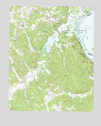
Rockport, TN USGS Topographic Map
Click on map above to begin viewing in our Map Viewer.

This topographic map contains these locations and features:
Feature Name Type Latitude Longitude GNIS ID View Map
Ammon CreekStreamN35.9223°W88.0911°1275663View Map
Ayres HollowValleyN35.9025°W88.0022°1276032View Map
Badger CreekStreamN35.9698°W88.0564°1304914View Map
Baggett BranchStreamN35.9142°W88.1009°1276076View Map
Baker CemeteryCemeteryN35.9556°W88.0275°1276155View Map
Ballard BranchStreamN35.9581°W88.0539°1304943View Map
Birdsong CreekStreamN35.9828°W88.0200°1277516View Map
Birdsong Creek SubdivisionPopulated PlaceN35.9876°W88.0445°1310598View Map
Birdsong Dock and ResortLocaleN35.9692°W88.0467°1305256View Map
Birdsong Drive-InLocaleN35.9819°W88.0789°2647747View Map
Birdsong HeightsPopulated PlaceN35.9792°W88.0492°1277517View Map
Brown CemeteryCemeteryN35.9878°W88.0725°1278549View Map
Camden Bay SubdivisionPopulated PlaceN35.9814°W88.0436°1310601View Map
Camps School (historical)SchoolN35.8920°W88.1170°1316805View Map
Caney BranchStreamN35.9115°W88.0998°1305669View Map
Caney Fork CemeteryCemeteryN35.8887°W88.0920°1279572View Map
Capps CemeteryCemeteryN35.8998°W88.0445°1279634View Map
Capps HollowValleyN35.8986°W88.0365°1279639View Map
Center Hill Community CenterBuildingN35.9762°W88.1081°1316808View Map
Center Hill SchoolSchoolN35.9762°W88.1078°1280129View Map
Chalk Level Baptist Church (historical)ChurchN35.9870°W88.0678°1644691View Map
Chalk Level School (historical)SchoolN35.9870°W88.0670°1316810View Map
Chalk Level Volunteer Fire Department Station 1BuildingN35.9744°W88.0878°2654160View Map
ChalklevelPopulated PlaceN35.9867°W88.0650°1305840View Map
ChasevillePopulated PlaceN35.8773°W88.1131°1314822View Map
Coldbranch HollowValleyN35.9409°W88.0107°1280908View Map
Commissioner District 1CivilN35.9065°W88.0806°2464208View Map
Conley BranchStreamN35.9276°W88.0814°1281086View Map
Cooleys Landing (historical)LocaleN35.9917°W88.0081°1644692View Map
Coon CreekStreamN35.9028°W88.1228°1281166View Map
CoxburgPopulated PlaceN35.8992°W88.0361°1314900View Map
Crockets Landing (historical)LocaleN35.9934°W88.0064°1316818View Map
Dalton CemeteryCemeteryN35.9567°W88.0492°1281985View Map
Dalton CreekStreamN35.9595°W88.0514°1306256View Map
Datrallo landingLocaleN35.9745°W88.0239°1644696View Map
Duck River BarBarN35.9453°W88.0078°1644750View Map
Duck River SuckRapidsN35.9623°W88.0242°1283049View Map
Fairview SchoolSchoolN35.9384°W88.1170°1284038View Map
Flowers Chapel (historical)ChurchN35.9884°W88.0645°1316830View Map
Ford CemeteryCemeteryN35.9948°W88.0611°1284563View Map
Fry CemeteryCemeteryN35.8967°W88.0250°1284994View Map
GismondaPopulated PlaceN35.9592°W88.1181°1315116View Map
Gossett CemeteryCemeteryN35.9059°W88.0964°1285744View Map
Gossetts LandingLocaleN35.9801°W88.0223°1644706View Map
Green Hatley BranchStreamN35.9290°W88.0761°1286092View Map
Green Hill Baptist Church (historical)ChurchN35.9251°W88.0734°1644707View Map
Green Hill School (historical)SchoolN35.9231°W88.0720°1316833View Map
Hardin CemeteryCemeteryN35.9956°W88.0523°1286821View Map
Hardin Store (historical)LocaleN35.9948°W88.0586°1316836View Map
Hatley CemeteryCemeteryN35.9362°W88.0661°1287138View Map
Hauk Hatley BranchStreamN35.9409°W88.0778°1287151View Map
Holladay Division (historical)CensusN35.9056°W88.1059°1648604View Map
Jepp BranchStreamN35.9537°W88.0928°1289390View Map
Liberty CemeteryCemeteryN35.9084°W88.1211°1291115View Map
Little Birdsong CreekStreamN35.9453°W88.0784°1291390View Map
Little Island (historical)IslandN35.9434°W88.0003°1310659View Map
Lupper CemeteryCemeteryN35.9520°W88.0370°1292292View Map
Malin CemeteryCemeteryN35.8953°W88.0614°1292527View Map
Matthews CemeteryCemeteryN35.8781°W88.1175°1292957View Map
McCauleys BluffCliffN35.9551°W88.0195°1293136View Map
McCauleys Bluff LandingLocaleN35.9534°W88.0186°1644712View Map
Mill HollowValleyN35.9183°W88.0140°1293876View Map
Moore BranchStreamN35.9717°W88.1025°1294242View Map
Moore ChuteChannelN35.9442°W88.0003°1310662View Map
Mount MoriahPopulated PlaceN35.9623°W88.0450°1294668View Map
Mount Moriah Cumberland Presbyterian Church (historical)ChurchN35.9620°W88.0445°1644719View Map
Mount Moriah School (historical)SchoolN35.9617°W88.0456°1316859View Map
Nowell CemeteryCemeteryN35.9306°W88.1173°1296003View Map
Peebles CemeteryCemeteryN35.9237°W88.0103°1297109View Map
Reeves HollowValleyN35.9170°W88.0054°1299189View Map
RockportPopulated PlaceN35.9420°W88.0175°1315829View Map
Rockport LandingLocaleN35.9431°W88.0134°1315830View Map
Russell Field Lookout TowerTowerN35.9173°W88.0384°1647789View Map
Shiloh Baptist ChurchChurchN35.9609°W88.1106°1303585View Map
Shiloh CemeteryCemeteryN35.9598°W88.1106°1644738View Map
Stillhouse HollowValleyN35.8925°W88.0163°1271429View Map
Suck BarBarN35.9634°W88.0217°1310621View Map
Thompsons Point LandingLocaleN35.9698°W88.0245°1644741View Map
Tie HillSummitN35.9653°W88.0864°1272630View Map
Tie Hill School (historical)SchoolN35.9601°W88.0884°1316889View Map
Tippitt CemeteryCemeteryN35.8878°W88.0736°1272673View Map
Trotters Ferry (historical)CrossingN35.9920°W88.0053°1310624View Map
Trotters LandingLocaleN35.9909°W88.0017°1314423View Map
Turkey CreekStreamN35.9095°W88.1056°1273011View Map
West Tennessee Boy Scout CampLocaleN35.9684°W88.0661°1305633View Map
White BranchStreamN35.9076°W88.1111°1274333View Map
Wildlife Cove VillagePopulated PlaceN35.9709°W88.0423°1310628View Map
Woods HollowValleyN35.8924°W88.0299°1275087View Map
Wyly CemeteryCemeteryN35.9912°W88.0389°1275205View Map
York BranchStreamN35.9634°W88.0659°1275302View Map
Young Farmers and Homemakers CampLocaleN35.9612°W88.0692°1316904View Map

Note: Coordinates in the location and feature list above are referenced to NAD83 datum.


Copyright (C) 2008-2024 Ryan Niemi / Sunset Dynamics ... All Rights Reserved