TopoQuest Logo
Do you find TopoQuest useful?
Help keep TopoQuest running and adding new maps/features by donating!
Bitcoin:  19c7KJd3qBynnjoSw5npx9KScwjBe4ifkT
Litecoin:  LXs6TkuXGGXo1vDsWCkWVdjQX94eUKd6ui
Home View Maps Find Maps Find Places Resources & Links


Seventeen Creek, Tennessee Topographic Map

USGS Map Title: Seventeen Creek, TN
USGS Map MRC: 35088H2
DRG (GeoTIFF) Download: o35088h2.tif


Neighboring USGS Topographic Map Quads:


  Vale, TN  
36088A3
 

  Bruceton, TN  
36088A2
 

  Camden, TN  
36088A1
 

  Buena Vista, TN  
35088H3
 

  Seventeen Creek, TN  
35088H2
 

  Rockport, TN  
35088H1
 

  Yuma, TN  
35088G3
 

  Holladay, TN  
35088G2
 

  Sugar Tree, TN  
35088G1


Map MRC Location:

N36°
W89°
N36°
W88°
H8 H7 H6 H5 H4 H3 H2 H1
G8 G7 G6 G5 G4 G3 G2 G1
F8 F7 F6 F5 F4 F3 F2 F1
E8 E7 E6 E5 E4 E3 E2 E1
D8 D7 D6 D5 D4 D3 D2 D1
C8 C7 C6 C5 C4 C3 C2 C1
B8 B7 B6 B5 B4 B3 B2 B1
A8 A7 A6 A5 A4 A3 A2 A1
N35°
W89°
N35°
W88°

Seventeen Creek, TN USGS 1:24K Topographic Map Preview:
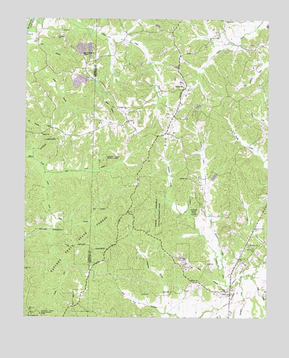
Seventeen Creek, TN USGS Topographic Map
Click on map above to begin viewing in our Map Viewer.

This topographic map contains these locations and features:
Feature Name Type Latitude Longitude GNIS ID View Map
Abbott BranchStreamN35.9926°W88.2092°1275416View Map
Butler ChurchChurchN35.9517°W88.2417°1305568View Map
Caney BranchStreamN35.8884°W88.1459°1279554View Map
Carroll School (historical)SchoolN35.9842°W88.2200°1320384View Map
Chalk Level Volunteer Fire Department Station 2BuildingN35.9721°W88.1670°2653925View Map
Coldspring BranchStreamN35.8770°W88.1773°1280909View Map
Cooper School (historical)SchoolN35.9948°W88.1903°1316814View Map
Cotton Creek Hunting Club DamDamN35.9901°W88.2184°1302271View Map
Cotton Creek Hunting Club LakeReservoirN35.9901°W88.2184°1302270View Map
District 18 (historical)CivilN35.9417°W88.2487°1325891View Map
Divider SchoolSchoolN35.9717°W88.1687°1282507View Map
East Fork Blunt CreekStreamN35.9356°W88.2398°1283332View Map
Flowers CemeteryCemeteryN35.8856°W88.1748°1284512View Map
Fourteen CreekStreamN35.8951°W88.1484°1284730View Map
Friendship CemeteryCemeteryN35.9926°W88.2339°1284926View Map
Hicks CemeteryCemeteryN35.8845°W88.1892°1287651View Map
Lester Jackson DamDamN35.9334°W88.1534°1302213View Map
Lester Jackson LakeReservoirN35.9341°W88.1526°1302212View Map
Liberty CemeteryCemeteryN35.9337°W88.1664°1644710View Map
Liberty ChurchChurchN35.9337°W88.1664°1291132View Map
Maple Creek (historical)Populated PlaceN35.8770°W88.2464°1326667View Map
Mount Comfort Missionary Baptist ChurchChurchN35.8756°W88.2484°1326896View Map
New Friendship ChurchChurchN35.9848°W88.2206°1295481View Map
Nole School (historical)SchoolN35.9409°W88.1873°1316862View Map
Nowell CemeteryCemeteryN35.8976°W88.1564°1296002View Map
Palestine CemeteryCemeteryN35.9048°W88.1334°1644724View Map
Palestine ChurchChurchN35.9051°W88.1339°1296683View Map
Pierce CemeteryCemeteryN35.9928°W88.1511°1297417View Map
Pleasant HillPopulated PlaceN35.9628°W88.2028°1315734View Map
Pleasant Hill Baptist ChurchChurchN35.9626°W88.2031°1644725View Map
Pleasant Hill CemeteryCemeteryN35.9628°W88.2036°1644726View Map
Pleasant Hill School (historical)SchoolN35.9615°W88.2012°1316869View Map
Pond BranchPopulated PlaceN35.9542°W88.2370°1646051View Map
Pond Branch School (historical)SchoolN35.9584°W88.2375°1320360View Map
RobisonPopulated PlaceN35.9951°W88.2320°1299719View Map
Sassafras Grove Church (historical)ChurchN35.8759°W88.2414°1320364View Map
Seventeen CreekStreamN35.8901°W88.1392°1301108View Map
South Fork Blunt CreekStreamN35.9356°W88.2400°1275411View Map
Sycamore CreekStreamN35.8898°W88.1386°1272001View Map
Union Baptist ChurchChurchN35.8901°W88.1642°1304228View Map
Walkers Store (historical)LocaleN35.9881°W88.2139°1320385View Map
Webb BranchStreamN35.9178°W88.2364°1274006View Map
Whiteoak School (historical)SchoolN35.9259°W88.1625°1316897View Map
Wiley School (historical)SchoolN35.9056°W88.2023°1316900View Map
Wolf CreekStreamN35.8915°W88.1325°1274950View Map

Note: Coordinates in the location and feature list above are referenced to NAD83 datum.


Copyright (C) 2008-2025 Ryan Niemi / Sunset Dynamics ... All Rights Reserved