TopoQuest Logo
Do you find TopoQuest useful?
Help keep TopoQuest running and adding new maps/features by donating!
Bitcoin:  19c7KJd3qBynnjoSw5npx9KScwjBe4ifkT
Litecoin:  LXs6TkuXGGXo1vDsWCkWVdjQX94eUKd6ui
Home View Maps Find Maps Find Places Resources & Links


Bucklin NW, Missouri Topographic Map

USGS Map Title: Bucklin NW, MO
USGS Map MRC: 39092H8
DRG (GeoTIFF) Download: o39092h8.tif


Neighboring USGS Topographic Map Quads:


  Milan SE, MO  
40093A1
 

  Winigan, MO  
40092A8
 

  Nind, MO  
40092A7
 

  Shelby, MO  
39093H1
 

  Bucklin NW, MO  
39092H8
 

  New Boston, MO  
39092H7
 

  Brookfield, MO  
39093G1
 

  Bucklin, MO  
39092G8
 

  New Cambria West, MO  
39092G7


Map MRC Location:

N40°
W93°
N40°
W92°
H8 H7 H6 H5 H4 H3 H2 H1
G8 G7 G6 G5 G4 G3 G2 G1
F8 F7 F6 F5 F4 F3 F2 F1
E8 E7 E6 E5 E4 E3 E2 E1
D8 D7 D6 D5 D4 D3 D2 D1
C8 C7 C6 C5 C4 C3 C2 C1
B8 B7 B6 B5 B4 B3 B2 B1
A8 A7 A6 A5 A4 A3 A2 A1
N39°
W93°
N39°
W92°

Bucklin NW, MO USGS 1:24K Topographic Map Preview:
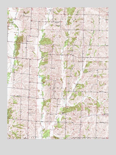
Bucklin NW, MO USGS Topographic Map
Click on map above to begin viewing in our Map Viewer.

This topographic map contains these locations and features:
Feature Name Type Latitude Longitude GNIS ID View Map
Baker CemeteryCemeteryN39.8792°W92.9382°713565View Map
Baker CemeteryCemeteryN39.9436°W92.9552°713566View Map
Baugher CemeteryCemeteryN39.9256°W92.9457°713746View Map
Bull BranchStreamN39.9836°W92.9902°715024View Map
Clapp SchoolSchoolN39.9945°W92.9794°715864View Map
Davis SchoolSchoolN39.9425°W92.9452°716739View Map
GarnerPopulated PlaceN39.9659°W92.9766°733983View Map
Garner ChurchChurchN39.9678°W92.9766°718348View Map
Hackler SchoolSchoolN39.8989°W92.9327°718959View Map
Hamilton BranchStreamN39.9075°W92.9291°719027View Map
Harper SchoolSchoolN39.9159°W92.9835°719132View Map
Hill SchoolSchoolN39.9878°W92.8771°719607View Map
Hybrid (historical)Populated PlaceN39.9222°W92.9735°740166View Map
JohnstownPopulated PlaceN39.9034°W92.9744°740972View Map
Mount Hope ChurchChurchN39.9859°W92.9360°722766View Map
Nester ChapelChurchN39.9586°W92.9194°723174View Map
Nester SchoolSchoolN39.9200°W92.8821°723175View Map
New Boston BranchStreamN39.9467°W92.9038°723189View Map
Phillips SchoolSchoolN39.9486°W92.9080°724298View Map
Pleasant Grove Baptist CemeteryCemeteryN39.8968°W92.8823°2702419View Map
Pleasant Grove ChurchChurchN39.8975°W92.8816°724496View Map
Pulliam CemeteryCemeteryN39.9014°W92.9969°724991View Map
Sam BranchStreamN39.9770°W92.9249°725988View Map
Snowdon (historical)Populated PlaceN39.8786°W92.9399°740165View Map
Snowdon Post OfficePost OfficeN39.8786°W92.9405°759955View Map
Thudium SchoolSchoolN39.9828°W92.9349°727636View Map
Township of BakerCivilN39.9199°W92.9244°766912View Map
Warner SchoolSchoolN39.8909°W92.8810°728356View Map
White SchoolSchoolN39.8756°W92.9758°728770View Map
Winigan CreekStreamN39.8770°W92.9524°729000View Map
Wyant CemeteryCemeteryN39.9078°W92.9380°729174View Map

Note: Coordinates in the location and feature list above are referenced to NAD83 datum.


Copyright (C) 2008-2025 Ryan Niemi / Sunset Dynamics ... All Rights Reserved